Partager
Facebook TwitterRéseau Sociaux UNESCO
Facebook Youtube Twitter RSS Patrimoine mondial Avertissement SyndicationVia Appia. Regina Viarum
Situations géographiques multiples (19)
| ID | Nom & Situation | État partie | Coordonnées | Bien | Zone tampon |
|---|---|---|---|---|---|
| 1708-001 | The Via Appia in Rome, from the 1st to the 13th mile | Italie |
N41 50 47.36 E12 31 50.69 |
381,48 ha | 2 641,96 ha |
| 1708-002 | The Via Appia across Alban Hills | Italie |
N41 43 20.63 E12 39 54.24 |
20,34 ha | 39,19 ha |
| 1708-003 | Tarracina and the crossing of the Lautulae Pass | Italie |
N41 17 33.8 E13 15 45.8 |
755,25 ha | 834,96 ha |
| 1708-004 | The Via Appia in Fundi | Italie |
N41 21 31.58 E13 25 37.25 |
14,54 ha | 18,68 ha |
| 1708-005 | The Via Appia at the Itri Pass | Italie |
N41 19 8.57 E13 28 53.55 |
32,82 ha | 158,21 ha |
| 1708-006 | The Via Appia from 83rd mile to Formiae | Italie |
N41 15 11 E13 35 39.9 |
19,58 ha | 246,33 ha |
| 1708-007 | Minturnae and the Garigliano crossing | Italie |
N41 14 25.7 E13 46 2.5 |
64,11 ha | 730,39 ha |
| 1708-008 | The Via Appia from Sinuessa to the Pagus Sarclanus | Italie |
N41 8 16.3 E13 51 30.6 |
85,16 ha | 383,87 ha |
| 1708-009 | Ancient Capua | Italie |
N41 4 59.34 E14 15 17 |
25,24 ha | 242,57 ha |
| 1708-010 | Beneventum and the Arch of Trajan | Italie |
N41 7 52.46 E14 46 28.63 |
58,35 ha | 207,54 ha |
| 1708-011 | The Via Appia on the route from Beneventum to Aeclanum | Italie |
N41 4 28.3 E14 55 56.6 |
169,97 ha | 1 286,08 ha |
| 1708-012 | The Via Appia in the upper Bradano Valley | Italie |
N40 56 54.85 E15 54 35.72 |
351,45 ha | 6 772,51 ha |
| 1708-013 | Tarentum | Italie |
N40 28 16.31 E17 14 31.59 |
6,41 ha | 108,77 ha |
| 1708-014 | The Via Appia from Mesochorum to Scamnum | Italie |
N40 30 52.64 E17 37 11.58 |
262,25 ha | 1 384,93 ha |
| 1708-015 | Brundisium | Italie |
N40 38 13.11 E17 56 37.38 |
69,4 ha | 121,01 ha |
| 1708-016 | The Appia Traiana from Beneventum to Aequum Tuticum | Italie |
N41 12 10.78 E14 57 54.97 |
200,43 ha | 1 171,66 ha |
| 1708-017 | The Appia Traiana from Aecae to Herdonia | Italie |
N41 20 45.69 E15 28 59.65 |
246,86 ha | 8 322,03 ha |
| 1708-018 | The Appia Traiana at Canusium and the Ofanto course | Italie |
N41 17 55.62 E16 7 48.85 |
520,22 ha | 4 008 ha |
| 1708-019 | The Appia Traiana along the Adriatic coast, through Egnatia | Italie |
N40 45 18.6 E17 40 35.03 |
1 356,06 ha | 11 527,1 ha |
Cartes
| Date | Titre | |
|---|---|---|
|
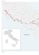
2024 | Via Appia. Regina Viarum - maps of the inscribed property |
Les dossiers de proposition d’inscription produits par les États parties sont publiés par le Centre du patrimoine mondial sur son site Internet et/ou dans des documents de travail afin de garantir la transparence, l’accès à l’information et de faciliter la préparation d’analyses comparatives par d’autres États parties soumissionnaires.
Le contenu de chaque dossier de proposition d’inscription relève de la responsabilité exclusive de l'État partie concerné. La publication d’un dossier de proposition d’inscription, y compris les cartes et les noms, ne saurait être interprétée comme exprimant une prise de position de la part du Comité du patrimoine mondial ou du Secrétariat de l'UNESCO à propos de l’histoire ou du statut juridique d'un pays, d'un territoire, d'une ville ou d'une zone, ou de ses frontières.