Stonehenge, Avebury et sites associés
Stonehenge, Avebury and Associated Sites
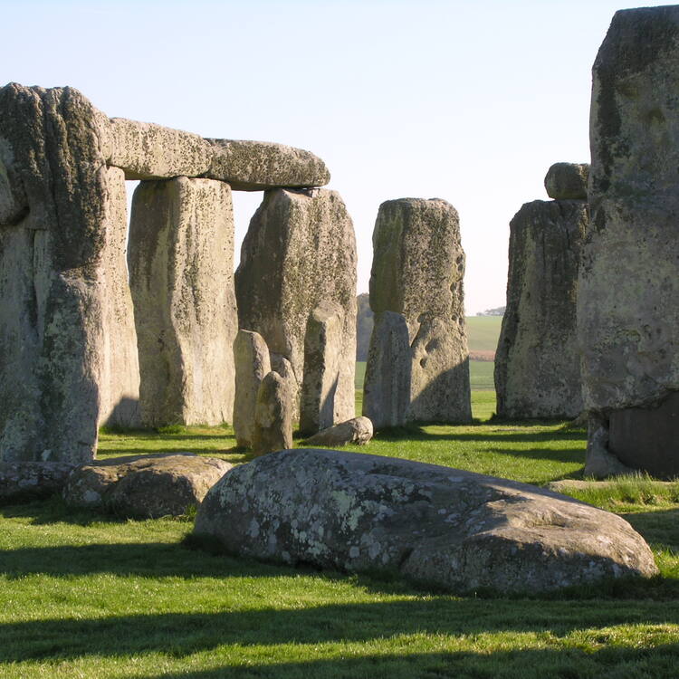
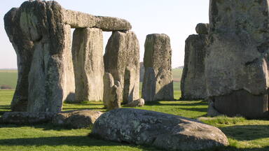
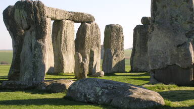
Stonehenge and Avebury, in Wiltshire, are among the most famous groups of megaliths in the world. The two sanctuaries consist of circles of menhirs arranged in a pattern whose astronomical significance is still being explored. These holy places and the nearby Neolithic sites are an incomparable testimony to prehistoric times.
La description est disponible sous licence CC-BY-SA IGO 3.0
Stonehenge, Avebury et sites associés
Stonehenge et Avebury, dans le Wiltshire, sont parmi les ensembles mégalithiques les plus célèbres du monde. Ces deux sanctuaires sont constitués de cercles de menhirs disposés selon un ordre aux significations astronomiques encore mal expliquées. Ces lieux sacrés et les divers sites néolithiques proches sont des témoins irremplaçables de la préhistoire.
La description est disponible sous licence CC-BY-SA IGO 3.0
ستونهنج وأفيبوري والمواقع الملحقة بها
يعدّ ستونهنج وأفيبوري في ويلتشاير من المجمعات المغليثية الأشهر عالمياً وهما ضريحان مؤلفان من دوائر من المنهير (النصب الصخرية العمودية) المرتّبة وفق نظام يحمل معاني فلكية لم يتم فهمها بعد. ويشكل هذان المكانان المقدسان ومختلف المواقع النيوليتية القريبة منهما شهوداً لا مثيل لها على مرحلة ما قبل التاريخ.
source: UNESCO/CPE
La description est disponible sous licence CC-BY-SA IGO 3.0
“巨石阵”、埃夫伯里及周围的巨石遗迹
位于威尔特郡的“巨石阵”、埃夫伯里是世界上最负盛名的巨石林,它们由巨石围成圆圈,其排列方式对天文学的重要意义仍在探索之中。这个圣地和周围的新石器时代遗址为研究史前时代提供了至关重要的证据。
source: UNESCO/CPE
La description est disponible sous licence CC-BY-SA IGO 3.0
Мегалитические памятники Стоунхендж, Эйвбери и прилегающие археологические объекты
Стоунхендж и Эйвбери в Уилшире являются одной из самых известных групп мегалитов в мире. Эти два святилища состоят из выстроенных кольцом больших каменных столбов-менгиров, поставленных в определенном порядке, астрономическое значение которого все еще не объяснено. Эти священные места и прилегающие неолитические объекты являются уникальными свидетельствами доисторической цивилизации.
source: UNESCO/CPE
La description est disponible sous licence CC-BY-SA IGO 3.0
Stonehenge, Avebury y sitios anejos
Situados en el condado de Wiltshire, los conjuntos megalíticos de Stonehenge y Avebury figuran entre los más célebres del mundo. Ambos santuarios están constituidos por círculos de menhires dispuestos en un orden cuya significación astronómica todavía no se ha dilucidado. Estos lugares sagrados y los distintos sitios neolíticos de los alrededores son testimonios incomparables de los tiempos prehistóricos.
source: UNESCO/CPE
La description est disponible sous licence CC-BY-SA IGO 3.0
ストーンヘンジ、エーヴベリーと関連する遺跡群
イングランド南部のソールズベリー平原にあるストーンサークル(環状列石)で有名な巨石遺跡。直径約100mの土盛りの遺構の内側に、立石の輪と穴が同心円状に広がっている。BC2000年~同1600年ごろのものと考えられているが、その目的は墓域、太陽崇拝、天文台など諸説があり、謎に包まれている。ストーンヘンジの北約30kmほどにあるエーヴベリーにも同様の遺跡がある。source: NFUAJ
Stonehenge, Avebury en bijbehorende locaties
Stonehenge en Avebury in Wiltshire behoren tot de meest bekende megalithische monumenten ter wereld. De twee heiligdommen bestaan uit cirkels van menhirs gerangschikt in een patroon waarvan de astronomische betekenis nog wordt onderzocht. Deze heilige plaatsen en de nabijgelegen neolithische gebieden vormen unieke overblijfselen van de prehistorie. Er zijn uitzonderlijk veel prehistorische monumenten bewaard gebleven. Ze geven inzicht in de dodenverering en ceremoniële praktijken uit deze periode en zijn het bewijs van prehistorische technologie, architectuur en astronomie. Daarnaast geeft de zorgvuldige plaatsing van de monumenten in relatie tot het landschap, meer inzicht in de Neolithische en Bronstijd.
Source : unesco.nl
Valeur universelle exceptionnelle
Brève synthèse
Le bien du patrimoine mondial de Stonehenge, Avebury, et les sites associés revêt une importance internationale en raison du caractère exceptionnel de ses ensembles de monuments préhistoriques. Stonehenge est le cercle de pierres préhistorique le plus sophistiqué au monde d’un point de vue architectural, tandis qu’Avebury est le plus vaste. Avec leurs monuments étroitement liés et leurs paysages associés, ils témoignent de pratiques cérémonielles et mortuaires du Néolithique et de l’âge du bronze, résultant d’environ 2000 ans d’utilisation continue et de construction de monuments entre environ 3700 et 1600 av. J.-C. Ils constituent à ce titre une incarnation unique de notre patrimoine collectif.
Le bien du patrimoine mondial comprend deux zones géologiques crayeuses du sud de la Grande-Bretagne dans lesquelles furent édifiés des ensembles de monuments cérémoniels et funéraires et des sites associés au Néolithique et à l’âge du bronze. Chaque zone contient un cercle central de mégalithes et de nombreux autres monuments. À Stonehenge, ceux-ci incluent l’Avenue, les Cursus, Durrington Walls, Woodhenge et la plus grande concentration de tumulus de Grande-Bretagne. À Avebury, ils incluent Windmill Hill, le tumulus long de West Kennet, le Sanctuaire, Silbury Hill, les Avenues de West Kennet et Beckhampton, les Palissades de West Kennet et de grands tumulus.
Stonehenge est l’un des monuments préhistoriques mégalithiques les plus impressionnants du monde en raison de la taille de ses mégalithes, la complexité de son plan concentrique et de sa conception architecturale, la forme des pierres – uniquement des blocs de grès Sarsen du Wiltshire et de pierre bleue de Pembroke – et la précision de la construction de l’ensemble.
À Avebury, le « henge » massif comprenant le plus grand ensemble circulaire mégalithique au monde et à Silbury Hill, le plus grand tumulus préhistorique d’Europe, montrent les techniques d’ingénierie exceptionnelles mises en œuvre pour créer des chefs d’œuvre architecturaux de terre et de mégalithes.
Le bien du patrimoine mondial abrite un nombre exceptionnel de vestiges de monuments et de sites préhistoriques, notamment des zones d’habitat et d’inhumation et de grandes constructions de terre et de pierres. Aujourd’hui, ils constituent avec leur environnement immédiat un paysage incomparable. Ces ensembles ont dû avoir une importance majeure pour leurs créateurs, comme l’atteste l’énorme investissement en temps et en énergie que représente leur construction. Ils donnent une idée des pratiques mortuaires et cérémonielles de cette période et constituent des preuves de la technologie, de l’architecture et de l’astronomie préhistoriques. Le choix précis de l’implantation des monuments dans le paysage nous aide à mieux comprendre le Néolithique et l’âge du bronze.
Critère (i) : Les monumentsde Stonehenge, Avebury et des sites associés témoignent de réalisations créatives et technologiques exceptionnelles de la préhistoire.
Stonehenge est le cercle de pierres préhistorique le plus sophistiqué au monde d’un point de vue architectural. Il est sans égal par sa conception et sa technique unique de construction, avec ses énormes pierres en linteau reposant sur le cercle extérieur, et les trilithes dont les formes s’emboîtent avec précision. Il se distingue par l’utilisation unique de deux types différents de pierres (pierre bleue et Sarsen), leurs dimensions (la plus grande pèse plus de 40 tonnes), et les distances sur lesquelles elles ont été transportées (jusqu’à 240 km). L’échelle même de certains des monuments environnants est également remarquable ; le Cursus de Stonehenge et l’Avenue font tous deux environ 3 km de long, tandis que Durrington Walls est le plus grand cercle de pierres connu de Grande-Bretagne, d’un diamètre d’environ 500 m, ce qui montre la capacité des peuples de la préhistoire à concevoir, dessiner et construire des structures de grande taille et de grande complexité.
Le cercle de pierres préhistorique d’Avebury est le plus vaste au monde. Le monument circulaire est constitué d’un énorme talus longé par un fossé de 1,3 km de circonférence à l’intérieur duquel se dressent 180 pierres levées brutes, d’extraction locale, formant le cercle extérieur, et deux plus petits cercles intérieurs. Partant de deux de ses quatre entrées, les Avenues West Kennet et Beckhampton, faites de pierres dressées disposées parallèlement, relient encore d’autres monuments disséminés dans le paysage. Autre monument exceptionnel, Silbury Hill est le tumulus le plus grand d’Europe. Construit vers 2400 av. J.-C., il s’élève à 39,5 m de haut et comprend un demi-million de tonnes de craie. La fonction de cet imposant monument, si habilement construit, reste obscure.
Critère (ii) : Le bien du patrimoine mondial offre une illustration exceptionnelle de l’évolution de la construction de monuments et de l’usage continu et de la formation du paysage sur plus de 2000 ans, du Néolithique ancien à l’âge du bronze. Les monuments et paysages ont eu une influence indéniable sur les architectes, les artistes, les historiens et les archéologues et conservent un potentiel considérable pour la recherche future.
Les monuments de terre et de mégalithes du bien du patrimoine mondial démontrent l’action humaine sur le paysage par la construction de monuments sur une période d’environ 2000 ans à partir de 3700 av. J.-C., témoignant de l’importance et de la grande influence des deux sites.
Depuis le XIIe siècle, lorsque Stonehenge fut considéré comme une des merveilles du monde par les chroniqueurs Henry de Huntington et Geoffrey de Monmouth, les sites de Stonehenge et Avebury ont excité la curiosité et ont été l’objet d’études et de spéculations. Depuis les premières recherches effectuées par John Aubrey (1626-1697), Inigo Jones (1573-1652) et William Stukeley (1687-1765), les sites ont eu une influence indéniable sur les architectes, les archéologues, les artistes et les historiens. Les deux parties du bien du patrimoine mondial offrent d’excellentes perspectives à la recherche future.
Aujourd’hui, pour certains, le site possède des associations spirituelles.
Critère (iii) : Les ensembles de monuments de Stonehenge et Avebury offrent une vision exceptionnelle des pratiques funéraires et cérémonielles dans les îles britanniques au Néolithique et à l’âge du bronze. Avec leur environnement immédiat et leurs sites associés, ils forment des paysages incomparables.
La conception, l’emplacement et les liens entre les monuments et les sites prouvent l’existence d’une société préhistorique riche et hautement organisée, capable d’agir sur l’environnement. Parmi les exemples remarquables, on peut citer l’alignement de l’Avenue de Stonehenge (probablement une voie processionnelle) et le cercle de pierres de Stonehenge sur l’axe du lever du soleil au solstice d’hiver et au solstice d’été, indiquant leur caractère astronomique et cérémoniel. À Avebury, les dimensions de certains éléments tels que l’Avenue de West Kennet, qui relie le cercle de pierre au sanctuaire éloigné de 2 km, confortent cette conclusion.
Une vision approfondie de l’évolution des pratiques mortuaires avec le temps se manifeste par l’usage de Stonehenge en tant que lieu de crémation, par le tumulus long de West Kennet, le plus grand tombeau collectif du Néolithique connu dans le Sud de l’Angleterre, et par les centaines de sites d’inhumation illustrant l’évolution des rites funéraires.
Intégrité
Le bien renferme à l’intérieur de ses limites les attributs qui incarnent ensemble sa valeur universelle exceptionnelle à Stonehenge et Avebury. On y trouve les très importants monuments du Néolithique et de l’âge du bronze qui illustrent le génie créateur et les compétences technologiques justifiant l’inscription du bien. Les paysages d’Avebury et de Stonehenge sont vastes – représentant tous deux environ 25 km² – et ils illustrent bien les relations entre les monuments ainsi que leur environnement paysager.
À Avebury, la limite a été étendue en 2008 pour inclure le long tumulus d’East Kennet et Fyfield Down avec son vaste réseau de champs de l’âge du bronze et ses pierres locales de Sarsen. À Stonehenge, la limite va être réétudiée pour envisager d’inclure d’importants monuments environnants associés comme le Robin Hood’s Ball, enclos néolithique pavé.
L’environnement de certains monuments importants s’étend au-delà des limites. Il convient d’envisager la création de zones tampons ou de directives de planifications fondées sur une étude approfondie de ce cadre afin de protéger à la fois le l’environnement des différents monuments et l’environnement d’ensemble du bien.
Le maintien de monuments du Néolithique et de l’âge du bronze à Stonehenge et Avebury est exceptionnel et remarquable étant donné leur âge – ils ont été édifiés et utilisés entre 3700 et 1600 av. J.-C. Les monuments en pierre et en terre ont conservé leur conception et leurs matériaux d’origine. Les structures en bois ont disparu mais des trous de piquets indiquent leur emplacement. Les monuments ont été régulièrement entretenus et réparés si nécessaire.
La présence d’importantes routes passantes traversant le bien du patrimoine mondial a un impact négatif sur son intégrité. Les routes coupent les relations entre Stonehenge et les monuments environnants, notamment l’A344 qui sépare le cercle de pierre de l’Avenue. À Avebury, des routes passent au milieu de certains monuments très importants, dont le Henge et la West Kennet Avenue. L’A4 sépare le Sanctuaire de son groupe de tumulus à Overton Hill. Les routes et les véhicules causent aussi des dommages à la matière de certains monuments, tandis que le bruit de la circulation et l’intrusion visuelle ont un impact négatif sur leur cadre. L’impact progressif du désordre engendré par l’encombrement routier doit être géré avec soin. Les pressions du développement exigent une bonne gestion. Il convient d’atténuer dans la mesure du possible les impacts du développement intrusif actuel.
Authenticité
Les interventions ont été essentiellement limitées aux fouilles et à la réédification de certaines pierres tombées ou enterrées à leur emplacement connu au début et à la moitié du XXe siècle, à des fins de meilleure compréhension. Le labourage, les animaux fouisseurs et les premières fouilles ont entraîné quelques pertes mais ce qui reste est remarquable par son caractère complet et sa concentration. Les matériaux et la substance de l’archéologie, étayés par les archives archéologiques, continuent à fournir un témoignage authentique des réalisations technologiques et créatives préhistoriques.
Cette survivance et l’immense potentiel de l’archéologie enterrée font de ce bien une ressource extrêmement importante pour la recherche archéologique qui continue à découvrir de nouveaux témoignages et à développer notre compréhension de la préhistoire. La recherche contemporaine a ainsi énormément amélioré notre compréhension du bien.
Les principaux monuments connus sont restés en majorité in situ et beaucoup sont encore des éléments dominants du paysage rural. Leur forme et leur conception sont bien préservées et les visiteurs peuvent facilement apprécier leur emplacement, leur cadre et leurs interrelations dont les associations constituent des paysages sans précédent.
À Stonehenge, plusieurs monuments ont conservé leur alignement sur le lever et le coucher du soleil au solstice, notamment le cercle de pierres, l’Avenue, Woodhenge, et le Durrington Walls Southern Circle et son Avenue.
Bien que l’utilisation cérémonielle initiale des monuments ne soit pas connue, ceux-ci conservent une signification spirituelle pour certaines personnes qui sont encore nombreuses à se rassembler près des deux cercles de pierres pour célébrer le solstice et faire d’autres observations. Stonehenge est connu et apprécié d’un nombre encore plus grand d’admirateurs qui le considèrent comme le plus célèbre monument préhistorique du monde.
Il convient de renforcer la compréhension des relations d’ensemble entre les vestiges – enfouis aussi bien qu’érigés – à Stonehenge et Avebury.
Éléments requis en matière de protection et de gestion
Le gouvernement britannique protège de deux façons les biens du patrimoine mondial situés en Angleterre. Tout d’abord, les différents bâtiments, monuments et paysages sont classés selon le Planning (Listed Buildings and Conservation Areas) Act de 1990 et l’Ancient Monuments and Archaeological Areas Act de 1979, et ensuite, selon le UK Spatial Planning System, en vertu des dispositions des Town and Country Planning Acts. Les différents sites à l’intérieur du bien sont protégés par le classement gouvernemental de bâtiments, monuments, jardins et paysages, pris isolément.
Les directives gouvernementales en matière de protection de l’environnement historique et du patrimoine mondial figurent dans le National Planning Policy Framework et la circulaire 07/09. Les politiques concernant la protection, la promotion, la conservation et la mise en valeur des biens du patrimoine mondial, de leur cadre et de leurs zones tampons figurent également dans des documents statutaires de planification. La protection du bien et de son cadre contre des projets de développement inadaptés pourrait être encore renforcée par l’adoption d’un document spécifique complémentaire de planification.
Au niveau local, le bien est protégé par le classement juridique de tous ses principaux monuments. Le Local Development Framework prévoit une politique générale particulière de protection de la valeur universelle exceptionnelle du bien contre un développement inapproprié, ainsi que des références adaptées à des stratégies et plans pertinents à tous les niveaux. La Wiltshire Core Strategy inclut une politique générale spécifique pour le bien du patrimoine mondial prévoyant la rédaction de directives complémentaires de planification pour en assurer la bonne mise en œuvre et donc la protection du bien du patrimoine mondial contre tout développement inapproprié. Cette politique reconnaît également la nécessité de réaliser pour cela une étude de l’environnement. Dès l’achèvement de la révision de la limite de Stonehenge, le travail sur l’étude de l’environnement pourra commencer.
L’autorité locale chargée de la planification est responsable du maintien de la protection par l’élaboration d’une politique et sa mise en œuvre effective. Elle décide de la suite à donner aux demandes de permis d’urbanisme en s’appuyant sur les plans de gestion de Stonehenge et d’Avebury comme élément essentiel d’étude. Ces plans prennent aussi en compte toute la gamme des valeurs qui caractérisent le site, outre sa valeur universelle exceptionnelle. Avebury est inclus dans la North Wessex Downs Area of Outstanding Natural Beauty, classement national statutaire destiné à assurer la conservation et la mise en valeur de la beauté naturelle du paysage.
Environ un tiers du bien à Stonehenge et Avebury appartient et est géré par des organismes de conservation : English Heritage, organisme gouvernemental non ministériel, The National Trust et la Royal Society for the Protection of Birds, deux organismes sans but lucratif. Les programmes agroenvironnementaux – exemples de partenariats entre des propriétaires privés et Natural England (organisme gouvernemental non ministériel) – sont très importants pour protéger et mettre en valeur le cadre de monuments préhistoriques par des mesures comme la restauration du gazon ou un nettoyage complet. Il est possible d’accéder à la plus grande partie du bien grâce à des droits de passage publics, des sentiers autorisés et un accès libre accordé par certains programmes agroenvironnementaux. Un accès libre et géré est autorisé au solstice. Il existe un nombre importants de propriétés privées à l’intérieur du bien et les résidents locaux ont donc un important rôle à jouer dans son administration.
Le bien est doté de plans de gestion efficaces, de coordonnateurs et de comités de direction à Stonehenge et Avebury. Il conviendrait d’avoir un système global intégré de gestion du bien mis en place par la création d’un groupe coordonnateur de partenariats pour Stonehenge et Avebury, tout en maintenant les groupes de direction de Stonehenge et Avebury pour traiter les questions spécifiquement locales et maintenir l’engagement significatif de la communauté. Un plan de gestion unique remplacera les deux plans de gestion distincts.
Une stratégie générale de gestion des visiteurs et d’interprétation, ainsi qu’une stratégie paysagère, doivent être mises en place pour optimiser l’accès et la compréhension du bien. Cela doit inclure une meilleure interprétation pour les visiteurs et la communauté locale, sur le site comme dans les musées locaux, en présentant des collections mises au jour dans le bien et en utilisant des publications et l’internet. Ces objectifs sont en cours d’étude à Stonehenge avec la création d’un centre d’accueil pour les visiteurs et l’élaboration de la Stratégie «Interprétation, acquisition de connaissances et participation». Le plan de gestion actualisé inclura une stratégie similaire pour Avebury. Les problèmes à résoudre et les perspectives de la gestion des visiteurs et du tourisme durable font l’objet d’objectifs précis dans les plans de gestion de Stonehenge et d’Avebury.
Une compréhension des relations d’ensemble entre les vestiges enfouis et érigés continue à se développer à travers des projets de recherche comme le projet « Entre les monuments » et des levés géophysiques complets. Des cadres de recherche ont été publiés pour le site et sont régulièrement revus, ce qui favorise l’approfondissement de la recherche pertinente. La « Stratégie de Woodland » est un exemple de projet de gestion paysagère qui, une fois mené à bien, pourra servir d’exemple pour inclure de nouveaux éléments de planification à l’échelle du paysage.
Il est important de maintenir et de renforcer les améliorations apportées aux monuments par la restauration du gazon, et d’éviter l’érosion des monuments en terre et de l’archéologie enterrée due à la pression des visiteurs et aux animaux fouisseurs.
Lors de l’inscription, l’État partie a accepté de fermer la route A344 pour réunir Stonehenge et son Avenue et d’améliorer l’environnement du cercle de pierres. Les travaux de fermeture de l’A344 seront achevés en 2013. Le projet comprend aussi un nouveau centre d’accueil des visiteurs à Stonehenge qui bénéficiera d’installations de haute qualité, et notamment d’interprétation de l’ensemble du bien du patrimoine mondial. Le désordre moderne sera notamment supprimé de l’environnement du cercle de pierres. Bien que d’importants progrès aient été faits, l’impact des routes et de la circulation reste un gros problème dans les deux parties du bien du patrimoine mondial. L’A303 continue à avoir un impact négatif sur l’environnement de Stonehenge, sur l’intégrité du bien et sur l’accès des visiteurs à certaines parties de l’ensemble du paysage. Il reste à trouver une solution à long terme. À Avebury, une Stratégie de la circulation dans le site du patrimoine mondial va être élaborée pour établir des directives et définir un ensemble général de mesures. Objectif : lutter contre l’impact négatif de la présence dominante des routes, de la circulation et de ses effets négatifs sur l’intégrité, l’état et l’environnement des monuments, et la facilité et la confiance avec lesquelles les visiteurs et la communauté locale peuvent explorer l’ensemble du bien.
