World Heritage Committee inscribes two natural, one mixed, and four cultural sites onto UNESCO’s World Heritage List
The World Heritage Committee today inscribed two natural sites on UNESCO's World Heritage List: Teide National Park (Spain); Primeval Beech Forests of the Carpathian (Slovakia, Ukraine). The Committee also inscribed the Ecosystem and Relict Cultural Landscape of Lopé-Okanda (Gabon) as a mixed - cultural and natural - site. Four cultural sites were inscribed: the Richtersveld Cultural and Botanical Lanscape (South Africa) as a cultural landscape, and Twyfelfontein or /Ui-//aes (Namibia), the Kaiping Diaolou and Villages (China) and Samarra Archaeological City (Iraq), which was also placed on the List of World Heritage in Danger. It furthermore decided to approve the extension of the natural site of Jungfrau - Aletsch - Bietschhorn, (Switzerland).
Situated on the island of Tenerife, Teide National Park covers 18,990 ha and features the Teide-Pico Viejo stratovolcano that, at 3,718 m, is the highest peak in Spain. Standing 7,500m above the ocean floor, it is regarded as the world's third tallest volcanic structure and is situated in a spectacular environment. The visual impact of the site is all the greater due to atmospheric conditions that create constantly changing textures and tones in the landscape and a ‘sea of clouds' that forms a visually impressive backdrop to the mountain. Teide is of global importance in providing evidence of the geological processes that underpin the evolution of oceanic islands, complementing those of volcanic properties already on the World Heritage List, such as the Hawaii Volcanoes National Park (U.S.A.).
The Primeval Beech Forests of the Carpathian constitute a transnational serial property of ten separate components along a 185 km axis from the Rakhiv Mountains and the Chornohirskyi Range in the Ukraine, west along the Polonynian Ridge, to the Bukovské Vrchy and Vihorlat Mountains in Slovakia. The ten sites represent an outstanding example of undisturbed, complex temperate forests and exhibit the most complete and comprehensive ecological patterns and processes of pure stands of European beech across a variety of environmental conditions. They contain an invaluable genetic reservoir of beech and many species associated with, and dependent on, these forest habitats. They also represent an outstanding example of the re-colonization and development of terrestrial ecosystems and communities after the last ice age, a process which is still ongoing.
The Ecosystem and Relict Cultural Landscape of Lopé-Okanda demonstrates an unusual interface between dense and well conserved tropical rainforest and relict savannah environments with a great diversity of species, including endangered large mammals, and habitats. The site illustrates ecological and biological processes in terms of species and habitat adaptation to post-glacial climatic changes. It contains evidence of the successive passages of different peoples who have left extensive and comparatively well preserved remains of habitation around hilltops, caves and shelters, evidence of iron-working and a remarkable collection of some 1,800 petroglyphs, or rock carvings. The property's collection of Neolithic and Iron Age sites, together with the rock art found there, reflects a major migration route of Bantu and other peoples from West Africa along the River Ogooué valley to the north of the dense evergreen Congo forests and to central east and southern Africa, that has shaped the development of the whole of sub-Saharan Africa. This is Gabon's first World Heritage site.
The 160,000 ha. Richtersveld Cultural and Botanical Landscape of dramatic mountainous desert in the north-west part of South Africa constitutes a cultural landscape communally owned and managed. This property sustains the semi-nomadic pastoral livelihood of the Nama people, reflecting seasonal patterns that may have persisted for as much as two millennia in Southern Africa. It is the only area where the Nama still construct portable houses, haru oms. The property includes seasonal migrations and grazing grounds, stockposts (bases used by the herders as they move with their herds of sheep and cattle on a seasonal basis) and Nama rush mat houses, small hemispherical portable structures, consisting of a wooden frame of intersecting wooden hoops, covered over with fine mats of braided local rushes. The pastoralists inhabiting this property collect medicinal and other plants and have a strong oral tradition associated with different places and attributes of the landscape.
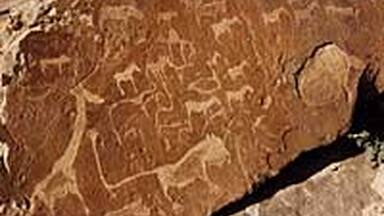
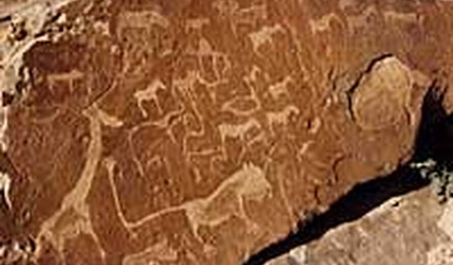
Twyfelfontein or /Ui-//aes has one of the largest concentrations of rock petroglyphs, i.e. rock carvings, in Africa. Over 2,000 figures have been documented to date. Most of these well-preserved carvings represent rhinoceroses, elephants, ostriches, and giraffes, as well as drawings of human and animal footprints. The property also includes six painted rock shelters with motifs of human figures in red ochre. The objects excavated from two parts of the property, including stone artefacts, ostrich eggshell beads, and schist pendants, dated from the Late Stone Age. Representations of humans, or of flying birds, are rare and it has been suggested that the figures were produced to illustrate the ritual transformation of humans into animals. The most celebrated example is the ‘Lion Man' a lion with five toes on each paw. The imagery suggests the rock art was linked to the belief system of hunter-gatherers who dominated the area until the arrival of pastoralists around 1000 AD. The site forms a coherent, extensive and high quality record of ritual practices relating to hunter-gatherer communities in this part of southern Africa over at least 2,000 years; and, eloquently illustrates the links between the ritual and economic practices of hunter-gatherers. This property is Namibia's first World Heritage site.
Kaiping Diaolou and Villages, feature the Diaolou, multi-storied defensive village houses in Kaiping, Guangdong Province, which display a complex and flamboyant fusion of Chinese and Western structural and decorative forms. They reflect the significant role of émigré Kaiping people in the development of several countries in South Asia, Australasia, and North America, during the late 19th and early 20th centuries, and the close links between overseas Kaiping and their ancestral homes. The property inscribed here consists of four groups of Diaolou, totaling some 1,800 tower houses in their village settings. They reflect the culmination of almost five centuries of tower-house building and the still strong links between Kaiping and the Chinese Diaspora. These buildings take three forms: communal towers built by several families and used as temporary refuge, of which 473 remain; residential towers built by individual rich families and used as fortified residences, of which 1,149 survive; and watch towers, the latest development, which account for 221 of the buildings. Built of stone, pise (compressed earth), brick or concrete, these buildings represent a complex and confident fusion between Chinese and western architectural styles. Retaining a harmonious relationship with the surrounding agricultural landscape, the Diaolou testify to the final flowering of local building traditions that started in the Ming period in response to local banditry.
Samarra Archaeological City, inscribed both on the World Heritage List and on the List of World Heritage in Danger is the site of a powerful Islamic capital city which ruled over the provinces of the Abbasid empire extending from Tunisia to Central Asia for a century. Located on both sides of the River Tigris 130km north of Baghdad, the length of the site from north to south is 41.5km; its width varies from 8km to 4km. It testifies to the architectural and artistic innovations that developed there and spread to the other regions of the Islamic world and beyond, the Great Mosque and its Spiral Minaret, 9th century, are among the numerous remarkable architecture monuments of the site, 80% of which remain to be excavated.
The extension of the natural World Heritage property of Jungfrau - Aletsch - Bietschhorn (first inscribed in 2001), expands the site to the east and west, bringing its surface area up to 82,400 ha., up from 53,900. The site provides an outstanding example of the formation of the High Alps, including the most glaciated part of the mountain range and the largest glacier in Eurasia. It features a wide diversity of ecosystems, including successional stages due particularly to the retreat of glaciers resulting from climate change. The site is of outstanding universal value both for its beauty and for the wealth of information it contains about the formation of mountains and glaciers, as well as ongoing climate change. It is also invaluable in terms of the ecological and biological processes it illustrates, notably through plan succession. Its impressive landscape has played an important role in European art, literature, mountaineering and alpine tourism.
The World Heritage Committee is expected to inscribe more sites later today.