Укрепленные рубежи Римской империи - Нижнегерманские рубежи
Frontiers of the Roman Empire – The Lower German Limes
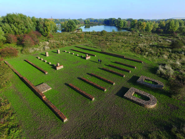
Following the left bank of the Lower Rhine River for approximately 400 km from the Rhenish Massif in Germany to the North Sea coast in the Netherlands, the transnational property consist of 102 components from one section of the frontiers of the Roman Empire, which in the 2nd century CE, stretched across Europe, the Near East, and North Africa, over 7,500 km. The property comprises military and civilian sites and infrastructure that marked the edge of Lower Germany from the 1st to 5th centuries CE. Archaeological remains in the property include legionary fortresses, forts, fortlets, towers, temporary camps, roads, harbours, a fleet base, a canal and an aqueduct, as well as civilian settlements, towns, cemeteries, sanctuaries, an amphitheatre, and a palace. Almost all of these archaeological remains are buried underground. Waterlogged deposits in the property have enabled a high degree of preservation of both structural and organic materials from the Roman periods of occupation and use.
La description est disponible sous licence CC-BY-SA IGO 3.0
Frontières de l’Empire romain – le limes de Germanie inférieure
Suivant la rive gauche du Rhin inférieur sur environ 400 km – du Massif rhénan en Allemagne à la côte de la mer du Nord aux Pays-Bas –, ce bien transnational est composé de 102 éléments appartenant à une section des frontières de l’Empire romain qui, au IIe siècle de notre ère, s’étendait sur 7 500 km à travers l’Europe, le Proche-Orient et l’Afrique du Nord. Le bien comprend des sites et des infrastructures militaires et civiles qui ont matérialisé la frontière de la Germanie inférieure du Ier au Ve siècle de notre ère. Les vestiges archéologiques du bien comprennent des camps légionnaires, des forts, des fortins, des tours, des camps temporaires, des routes, des ports, une base navale, un canal et un aqueduc, ainsi que des établissements civils, des villes, des cimetières, des sanctuaires, un amphithéâtre et un palais. La quasi-totalité de ces vestiges archéologiques est enfouie sous terre. Les gisements gorgés d’eau du bien ont permis un haut degré de préservation des matériaux structurels et organiques datant des périodes d’occupation et d’utilisation romaines.
La description est disponible sous licence CC-BY-SA IGO 3.0
تخوم الإمبراطورية الرومانية – الحدود الجرمانية الدنيا
يمتد هذا الموقع على طول 400 كم تقريباً بمحاذاة الضفة اليسرى لنهر الراين الأدنى، ويبدأ من كتلة جبال الراين في ألمانيا وينتهي في ساحل بحر الشمال في هولندا، ويتألف هذا الموقع العابر للحدود من 102 عنصراً ضمن قطاع واحد من حدود الإمبراطورية الرومانية، التي توسَّعت خلال القرن الثاني الميلادي لتمتد على طول 7500 كم عبر أوروبا والشرق الأوسط وشمال أفريقيا. ويضمُّ الموقع بين جنباته مواقع وبنى أساسية عسكرية ومدنية كانت نقاط علام للحدود الجرمانية الدنيا من القرن الأول الميلادي حتى القرن الخامس الميلادي. ويوجد في الموقع بقايا أثرية تتنوع بين قواعد عسكرية وحصون وتحصينات وأبراج، ومعسكرات مؤقتة وطرق وموانئ وقواعد للأساطيل، وقناة وقناة لجر المياه، ومستوطنات للمدنيين ومدن ومقابر ومعابد ومدرَّج وقصر، ولا يزال مجمل هذه البقايا الأثرية تقريباً مدفوناً تحت الأرض. وقد أدَّت الترسبات المشبعة بالمياه في الموقع، دوراً في حفظ المواد الإنشائية والعضوية بدرجة كبيرة، وهي تنحدر من الحقب التي سادت فيها الإمبراطورية الرومانية وقامت باستخدامها.
source: UNESCO/CPE
La description est disponible sous licence CC-BY-SA IGO 3.0
罗马帝国边境--下日耳曼界墙
从德国的莱茵山地到荷兰的北海沿岸,下日耳曼界墙由莱茵河下游左岸约400公里沿线的102个遗产点组成,是罗马帝国边境的一部分。公元2世纪,罗马帝国横跨欧洲、近东和北非,跨度超过7500公里。这些遗产点包括标识公元1-5世纪的下日耳曼边疆的军事和民用遗迹以及基础设施。该遗产地的考古遗迹包括军事基地、堡垒、塔楼、临时营地、道路、港口、舰队基地、运河和渡槽,以及平民居住区、城镇、墓地、避难所、圆形剧场和宫殿。几乎所有这些考古遗迹都埋在地下。遗迹中的浸水沉积物使罗马占领时期的结构和有机材料得到高度完好的保存。
source: UNESCO/CPE
La description est disponible sous licence CC-BY-SA IGO 3.0
Укрепленные рубежи Римской империи - Нижнегерманские рубежи
Этот транснациональный объект, протяженностью примерно 400 км вдоль левого берега реки Нижний Рейн от Рейнского массива в Германии до побережья Северного моря в Нидерландах, состоит из 102 компонентов, расположенных в части пограничной линии древней Римской империи, которая во II веке нашей эры простиралась через Европу, Ближний Восток и Северную Африку на более чем 7500 км. Нижнегерманские рубежи включают в себя военные и гражданские объекты и инфраструктуру, обозначавшие край Нижней Германии с I по V вв. н. э. Археологические находки на территории объекта включают военные базы, форты, крепости, башни, временные лагеря, дороги, гавани, базу флота, канал и акведук, а также гражданские поселения, города, кладбища, святилища, амфитеатр и дворец. Почти все эти археологические останки захоронены под землей. Заболоченные отложения позволили обеспечить высокую степень сохранности как структурных, так и органических материалов периода римской оккупации и использования.
source: UNESCO/CPE
La description est disponible sous licence CC-BY-SA IGO 3.0
Fronteras del Imperio Romano – Limes de la Baja Alemania
Siguiendo la ribera izquierda del Bajo Rin a lo largo de unos 400 km desde el Macizo renano en Alemania hasta la costa del Mar del Norte en los Países Bajos, este sitio transnacional consta de 102 componentes de una sección de las fronteras del Imperio Romano, que en el siglo II de nuestra era se extendía por Europa, Oriente Próximo y el Norte de África, a lo largo de 7.500 km. El sitio comprende emplazamientos e infraestructuras militares y civiles que marcaron el límite de la Baja Alemania entre los siglos I y V de nuestra era. Los vestigios arqueológicos del sitio incluyen campamentos de legionarios, fuertes, fortines, torres, campamentos temporarios, carreteras, puertos, una base para la flota, un canal y un acueducto, así como asentamientos civiles, ciudades, cementerios, santuarios, un anfiteatro y un palacio. Casi todos estos restos arqueológicos están enterrados. Los depósitos repletos de agua del sitio han permitido un alto grado de conservación de los materiales estructurales y orgánicos de los períodos romanos de ocupación y uso.
source: UNESCO/CPE
La description est disponible sous licence CC-BY-SA IGO 3.0
