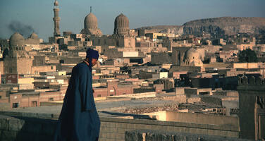
Historic Cairo
Factors affecting the property in 2007*
- Housing
- Identity, social cohesion, changes in local population and community
- Management systems/ management plan
- Water (rain/water table)
- Other Threats:
Dilapidated infrastructure
Factors* affecting the property identified in previous reports
- Earthquake in 1992 (issue resolved);
- Inappropriate reconstruction works (issue resolved);
- Rise of the underground water level;
- Dilapidated infrastructure;
- Neglect and lack of maintenance;
- Overcrowded areas and buildings;
- Uncontrolled development;
- Absence of a defined protection perimeter for the property and of a comprehensive Urban Conservation Plan;
- Absence of an integrated socio-economic revitalization plan linking the urban and the socio-cultural fabric of the city core.
International Assistance: requests for the property until 2007
Total amount approved : 398,900 USD
| 1999 |
Rehabilitation Programme for Islamic Cairo
(Approved)
Reapproval: 05 May, 2003 (n°1638 - 19,000 USD)
|
80,000 USD |
| 1998 | Rehabilitation Programme for Islamic Cairo (Approved) | 120,000 USD |
| 1998 | Preparation of the co-operation Programme for Historic ... (Approved) | 19,000 USD |
| 1998 | Exhibition on Historic Cairo in 1998 (Approved) | 5,000 USD |
| 1998 | Meeting in Paris on Islamic Cairo (Approved) | 14,900 USD |
| 1997 | Restoration of Al-Sinnari House, Historic Cairo (Approved) | 20,000 USD |
| 1995 | Second phase of the restoration of al-Sinnari House, ... (Approved) | 30,000 USD |
| 1992 | Restoration of monuments and sites of Old City of Cairo ... (Approved) | 50,000 USD |
| 1981 | 12-month expert services for the restoration of the ... (Approved) | 30,000 USD |
| 1979 | Draw up a project for the restauration and development ... (Approved) | 30,000 USD |
Missions to the property until 2007**
ICOMOS reactive monitoring missions in August 2002 and March 2005; World Heritage Centre mission in April 2007.
Conservation issues presented to the World Heritage Committee in 2007
The Committee, at its 30th session (Vilnius, 2006), had reiterated its concern as regards the lack of progress made in implementing the recommendations of the 2002 International Symposium. These included:
a) Designating Islamic Cairo as a Special Planning District, with buffer zones, in accordance with the provisions of the Operational Guidelines;
b) Preparing a comprehensive Urban Plan for the Conservation and Development of the Old City, whereby the conservation of historic buildings would be accompanied by appropriate development regulations to encourage the rehabilitation of the urban fabric, so as to ensure its compatibility with the historic character of Islamic Cairo;
c) Organizing regular meetings among Egyptian and international experts to review and discuss current conservation issues and projects.
The State Party did not submit a progress report as requested by Decision 30 COM 7B.50, but a list of project sites, in synoptic table form, concerning restoration works and other activities carried out or foreseen. No description or documentation was attached. However, the information available shows important progress in conservation of buildings and streets in the Old city. These efforts are not visible enough, scattered throughout the city, due to the absence of a comprehensive urban conservation plan that the authorities intend to initiate in the near future.
As suggested by the Committee in its Decision 30 COM 7B.50, the State Party proposed the change of name of the property to “Historic Cairo” (Document WHC-07/31.COM/8B.2). In addition, in response to the request expressed in the framework of the Retrospective Inventory, the State Party transmitted to the World Heritage Centre, a map representing the five components of the property. Some clarifications of the precise boundaries are still expected, before they can be presented to the Committee for approval.
Further to a request from the Supreme Council of Antiquities (SCA), alarmed by a considerable development project close to the Cairo Citadel, a mission was sent from the World Heritage Centre at very short notice in April 2007, and therefore, the ICOMOS expert residing in Cairo was not available to join. This development project (Cairo Financial Centre) is located on the verge of the boundary of the property, in the ancient quarries of the city, between the Cairo Citadel and the Mohamed Ali fortress. It consists of a number of buildings (hotel, offices, mall, etc.) located on a common base occupying a site of some 61,000m2 (advised by the developer, the exact site area is impossible to ascertain from information provided thus far). The maximum building height, taken from the developer’s information pack, is some 59.5 meters, i.e. some 51 meters above the Salah Salem road running along the Citadel (the exact heights are impossible to ascertain from information provided thus far). The shape and character of this very large complex, whose architectural language is mainly that of a commercial building, do not appear to be sensitive to the particular context of the site, both in terms of landscape and environmental conditions. From information provided thus far, indeed, it seems that this project would have a significant adverse impact on the visual integrity of the Citadel and its setting, which will be impossible to reverse.
The controversy raised by this project suggested that the issue was very sensitive and this is why the mission listened to presentations by both parties – the developer and the objectors, among them architects, urban planners and archaeologists. In order to be able to offer a balanced opinion, and one that is based on facts, the mission members requested that the developer makes available for study detailed architectural plans, sections, elevations, etc. printed to a measurable scale. These have thus far not been received. Considering the nature of the surrounding landscape and structures, which are very varied and rich in sculptural terms, it is impossible to arrive at a full understanding of view lines etc on the basis of drawings alone. This is why the mission has also requested from the developer that a scale model of the proposed scheme, showing the surrounding areas, the citadel and other structures, is made and offered for inspection. The mission expressed its concern that a project located in such a sensitive and tectonically complicated location was not analysed through site-specific study models, and that the final scheme was not assessed by a fully detailed model, essential to measure the impact of the project and to make a professional assessment. At the time of drafting this document, only presentation drawings were provided which do not allow an evaluation. The SCA has, further to the recommendation of the World Heritage Centre, halted the on-going construction works and an update should be available at the time of the Committee meeting.
Summary of the interventions
Decisions adopted by the Committee in 2007
31 COM 7B.56
Islamic Cairo (Egypt)
The World Heritage Committee,
1. Having examined Document WHC-07/31.COM/7B.Add,
2. Recalling Decisions 29 COM 7B.42 and 30 COM 7B.50, adopted at its 29th (Durban, 2005) and 30th (Vilnius, 2006) sessions respectively,
3. Takes note of the continuous efforts of the State Party to improve conservation of the property in the recent years;
4. Urges the State Party to implement the main recommendations of the 2002 Symposium report, subsequently endorsed by the World Heritage Committee in 2003, 2004, 2005 and 2006, notably:
a) To designate Islamic Cairo as a Special Planning District, and
b) To prepare a comprehensive Urban Plan for the Conservation and Development of the Old City, whereby the conservation of historic buildings would be accompanied by appropriate development regulations;
5. Also urges the State Party to put an immediate halt to the construction works of the Cairo Financial Centre close to the Citadel and to revise the project, once the plans and model have been provided for a thorough assessment;
6. Requests the State Party, considering the historic value of the project area, to envisage an international consultation to define an alternative to the existing project, notably by limiting its height to the level of the highway, so as to mitigate its impact on the urban landscape;
7. Also requests the State Party to submit to the World Heritage Centre, by 1 February 2008, a report on the implementation of the above recommendations for examination by the Committee at its 32nd session in 2008.
31 COM 8B.2
changes to names - Historic Cairo
The World Heritage Committee,
- Having examined Document WHC-07/31.COM/8B,
- Approves the proposed name change to Islamic Cairo as proposed by the Egyptian authorities. The name of the property becomes Historic Cairo in English and Le Caire historique in French.
Draft Decision: 31 COM 7B.56
The World Heritage Committee,
1. Having examined Document WHC-07/31.COM/7B.Add,
2. Recalling Decisions 29 COM 7B.42 and 30 COM 7B.50, adopted at its 29th (Durban, 2005) and 30th (Vilnius, 2006) sessions respectively,
3. Takes note of the continuous efforts of the State Party to improve conservation of the property in the recent years;
4. Urges the State Party to implement the main recommendations of the 2002 Symposium report, subsequently endorsed by the World Heritage Committee in 2003, 2004, 2005 and 2006, notably:
a) To designate Islamic Cairo as a Special Planning District, and
b) To prepare a comprehensive Urban Plan for the Conservation and Development of the Old City, whereby the conservation of historic buildings would be accompanied by appropriate development regulations;
5. Also urges the State Party to put an immediate halt to the construction works of the Cairo Financial Centre close to the Citadel and to revise the project, once the plans and model have been provided for a thorough assessment;
6. Requests the State Party, considering the historic value of the project area, to envisage an international consultation to define an alternative to the existing project, notably by limiting its height to the level of the highway, so as to mitigate its impact on the urban landscape;
7. Also requests the State Party to submit to the World Heritage Centre, by 1 February 2008, a report on the implementation of the above recommendations for examinationby the Committee at its 32nd session in 2008.
 Egypt
Egypt
* :
The threats indicated are listed in alphabetical order; their order does not constitute a classification according to the importance of their impact on the property.
Furthermore, they are presented irrespective of the type of threat faced by the property, i.e. with specific and proven imminent danger (“ascertained danger”) or with threats which could have deleterious effects on the property’s Outstanding Universal Value (“potential danger”).
** : All mission reports are not always available electronically.

