Historic Cairo
Historic Cairo
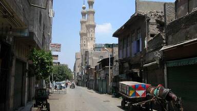
Tucked away amid the modern urban area of Cairo lies one of the world's oldest Islamic cities, with its famous mosques, madrasas, hammams and fountains. Founded in the 10th century, it became the new centre of the Islamic world, reaching its golden age in the 14th century.
Description is available under license CC-BY-SA IGO 3.0
Le Caire historique
Enserrée dans l'agglomération moderne du Caire se trouve l'une des plus anciennes villes islamiques du monde, avec ses prestigieuses mosquées, ses medersa, ses hammams et ses fontaines. Fondé au Xe siècle, Le Caire islamique est devenu le nouveau centre du monde islamique et il a atteint son âge d'or au XIVe siècle.
Description is available under license CC-BY-SA IGO 3.0
القاهرة التاريخية
محاطة بالعمران الحديث للقاهرة الحديثة، القاهرة القديمة هي إحدى أقدم مدن العالم الإسلاميّة بجوامعها ومدارسها وحماماتها وينابيعها. تأسست القاهرة الإسلاميّة في القرن العاشر واستحالت مركز العالم الإسلامي الجديد وبلغت عصرها الذهبي في القرن الرابع عشر.
source: UNESCO/CPE
Description is available under license CC-BY-SA IGO 3.0
开罗古城
开罗是世界上最古老的伊斯兰城市之一,隐没在现代城区中,有着著名的清真寺、伊斯兰学校、土耳其浴室以及喷泉。开罗建于公元10世纪,后成为伊斯兰世界的新中心,于14世纪达到鼎盛时期。
source: UNESCO/CPE
Description is available under license CC-BY-SA IGO 3.0
Исламский Каир
В стороне от шумных современных районов Каира находится один из древнейших в мире комплексов исламского градостроительства, со знаменитыми мечетями, медресе, банями («хаммамы») и фонтанами. Основанный в Х в., этот город стал новым центром исламского мира, достигнув своего «золотого века» в ХIV в.
source: UNESCO/CPE
Description is available under license CC-BY-SA IGO 3.0
El Cairo histórico
Circundada por la aglomeración moderna, la ciudad islámica de El Cairo es una de las más antiguas del mundo, con sus renombradas mezquitas, madrazas, baños de vapor públicos y fuentes. Fundada en el siglo X, llegó a ser el centro del mundo islámico, alcanzando su máximo esplendor en el siglo XIV.
source: UNESCO/CPE
Description is available under license CC-BY-SA IGO 3.0
カイロ歴史地区
エジプト・アラブ共和国の首都。その起源はローマ帝国にありますが、3度にわたるイスラーム王朝(10~16世紀)の首都とされました。旧市街にはイスラーム教学の中心として千年以上の歴史を刻んできたアズハル大学、イブン・トゥールーンなど数百のモスクが集中している。南方には十字軍との戦いで有名なサラディーンが築いた巨大な城塞跡などがある。source: NFUAJ
Historisch Caïro
Weggestopt tussen het moderne stedelijke gebied van Caïro, ligt een van ’s werelds oudste islamitische steden. De stad – met zijn beroemde moskeeën, madrassas, hammams en fonteinen – werd in de 10e eeuw gesticht, ontwikkelde zich tot het nieuwe centrum van de islamitische wereld en kende haar hoogtepunt in de 14e eeuw. Er zijn maar weinig steden in de wereld zo rijk aan oude gebouwen als Caïro: het historische centrum aan de oostelijke oever van de Nijl telt niet minder dan 600 monumenten die dateren uit de 7e tot de 20e eeuw, verdeeld over verschillende delen van de goed intact gebleven stad.
Source: unesco.nl

Outstanding Universal Value
Brief synthesis
Historic Cairo is one of the exceptional cities in the world, characterized by the extraordinary survival of its architectural, artistic and urban heritage, which fully expresses its long history and the diversity of its values. Its siting at a historic crossroads of international trade routes from Europe, Asia and Africa fostered its prosperity as a political, cultural and economic capital, a destination for scholars and a stop on major pilgrimage routes. The period between the 9th and 15th centuries – also known as the Islamic Renaissance – was a particularly golden age for the city, when pioneering scientists, doctors, astronomers, theologians and writers carried an influence and stature that stretched well beyond the Islamic World.
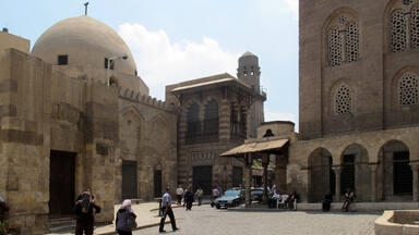
Historic Cairo still reflects its complex ‘medieval’ urban layout, which was respected and enhanced in later eras, to reflect is role as a political capital and to accommodate population growth. Its cohesive traditional urban scene combines elements of four capitals of Islamic states. Cairo was founded as the headquarter of the Fatimid Caliphate in 969 AD. During the Ayyubid state (1176 AD), the citadel was established as the headquarters of government. The Mamluk state (1250-1517 AD) saw the expansion and extension of Cairo’s cohesive urban fabric outside the walls of the Fatimid necropolis to encompass the earlier cities of Fustat (642 AD), Al -Askar (750 AD) and Al -Qata’i (879 AD) in which the mosque of Ahmed ibn Tulun (876-879 AD) is sited, with its spiral minaret and symmetrical arches opening on to a vast square court. Subsequently Cairo became the most important city of the Ottoman Caliphate (1517-1805 AD).
The 10th century Fatimid planning is the nucleus of the city, located inside the city fortification of Badr al-Gamali, with its remaining gates of Bab Zuwayla to the south, and Bab al-Nasr and Bab al-Futuh to the north. This ‘set the standard for later development’ and allowed future urban growth. Its construction extended in the form of lanes representing residential "Harats" for different sects, races and tribes that came with the Fatimids to Egypt, such as the Al-Barqiah harat near to the eastern wall, Al-Jawwaniyah harat and Harat Al-Atuf. The greatest street (Qasabat Al-Mu’izz) is in the middle of the city and extends from north to south, passing through squares and occasional streets. The distinctive and refined Fatimid architecture includes significant mosques such as Al-Azhar, Al-Hakim, Al-Aqmar and Salih Tala'i, mausoleums, shrines including Al-Juyushi, Sayida Ruqaya, Attka and Gafari, and Yehia Al-Shabih, and private dwellings, all of outstanding importance to the history of significant Islamic art and architecture.
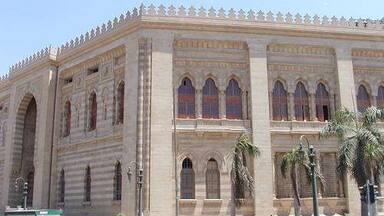
Historic Cairo developed further in the Ayyubid and Mamluk eras when the Fatimid plan was enlarged outside the walls in a cohesive urban fabric and it became the largest, most complex urban Islamic city in medieval times, and the capital of a vast empire. It was also a manifestation of the application of Islamic jurisprudence in its planning and the organization of areas for housing and trade. To reflect their political power, the Mamluk sultans constructed royal buildings in a new architectural style with those of the Bahri and Burgi dynasties displaying colourful architecture with Persian arches, minarets with finely chiselled cantilevers, tall façades with pointed arches, and balconies mounted on stalactites. The complexes of Sultan Qalawun, Sultan Barquq and Sultan Barsbay, Sultan Hassan Madrassa, Sultan Al-Ghori and Sultan Qaitbay still dominate Cairo's skyline. The streets were characterized and known by different types of activities and names according to the handicraft centers and the markets they pass through, such as Al-Nahhasin, Bain Al-Qasrain, Al-Kayamieya, Al-Megharbilin. Regulatory Controls were introduced to sustain the appearance and urban identity of the city.
Subsequently, the Ottomans maintained these religious buildings and the mediaeval urban patterns, but their princes also enriched the Islamic architecture. As limited space was available, they reconstructed ruined places, renovated multiple buildings that preceded them, and added new landmarks built following local traditions such as the Ibrahim Kalashni Tekkiya and Dome Complex in the historic Al-Darb Al-Ahmar district in central Cairo of 1517 AD. The Ottoman style was characterized by the use of decorative ceramic tiles with plant elements inspired by Turkish nature, such as in the Muhammad Ali Pasha Mosque in the Citadel 1815-1865.
The building of a new Cairo in the 19th century allowed Historic Cairo to remain largely intact. Buildings in the Baroque and Rococo European architectural styles of the 19th and early twentieth century appear in the neighborhoods of Sayeda Zainab and Al-Darb Al-Ahmar, as well as in the Sabil-s of Muhammad Ali in Al-Nahhasin, Al-Akkadin and Sabil Suleiman Agha Al-Silhdar in Al-Moez Street, while in the modern era residential buildings of Darb Al-Ahmar area and Al-Ahwash and the burial-tombs of Qaitbay necropolis reflect the revival of the Mamluk style (New mamluk).
Historic Cairo is an extraordinary survival not just in terms of grand buildings but because whole neighborhoods have survived, each with an exceptional richness of urban fabric and historic monuments spread throughout. These include an unparalleled number of Sabil-s, many still with their underground water tanks, Masjid-s, Madrasas, Kuttab-s, palaces and Bimaristan-s, all of which are still integrated into the urban areas which they served and respect the integrity of the original urban layout of the city: this arrangement is considered to be a ‘unique feature in the Islamic world’. Streets and squares still reflect long-standing and distinct commercial activities, underpinned by craft guilds, with streets and markets were named after crafts, such as Al-Nahhasin, Al-Maghrebel, and Shamaa’in, as well as foreign and local minorities and communities such as Kom Al-Sa`ida, the Moroccans, the Shawam and others. The city has also been the headquarters of the Coptic Orthodox Patriarchate in the Hanging Church of Virgin Mary in Ancient Egypt (1047 -1320 AD), the Church of the Virgin in Harat Zuweila (1320-1660 AD), the Church of the Virgin in Harat Al-Roum (1660-1799 AD), and the Church of Saint Mark in Azbakiya (1799 -1971 AD), as well as the Jewish rabbinic headquarters in the Eliyahu Temple in Fustat, which was then moved to the Jewish Quarter inside the Fatimid city of Cairo.
Cairo’s strategic location at the tip of the Delta, between the River Nile (east) and the Moqattam Hill (west), led to a continuous human interaction with the site that has shaped its settlements and architecture. An aqueduct, Sur Megra El-Ayoun dating back to medieval times, created a link between the city and the Nile that made it possible to accommodate, and accelerate Cairo’s development, and erect an extensive network of canals, cisterns, hammams and sabils. The historic southern port Al-Fustat was also strongly connected to the use of the Nile through the historic development of trade with Europe.
This richness of Historic Cairo’s architecture, culture and society has been documented by travelers and orientalists for centuries. It has been known variously to scholars, historians and residents as “Al Mahrousa”, “City of a Thousand and One Nights” and “City of a Thousand Minarets”. The city preserves half of the surviving monuments from the Middle Ages to date.
Criterion (i): The great monuments of Historic Cairo are a unique ensemble of architectural and artistic masterpieces which stand tall in the sky of Cairo. Each of them expresses rare artistic, aesthetic and architectural value, which might be enough for each to be considered as of outstanding global importance in the history of art and architecture in the world. Together they are an ensemble that reflects the highpoints of Tulunid, Fatamid, and Mamluk architecture.
The mosque of Ahmed ibn Tulun (876-79 AD), with its spiral minaret and symmetrical arches opening on to a vast square court, is an outstanding example of early Islamic architecture from the 9th and 10th centuries. The distinctive Fatimid architecture (969–1171 AD) is reflected in the city fortifications and gates, Al-Azhar, Al-Hakim, Al-Aqmar and Salih Tala'I mosque, and mausoleums and shrines. The extraordinary Bahri Mamluk (1250-1382 AD) and Burgi Mamluk (1382-1517 AD) monuments reign triumphant above the skyline of Cairo, the refinement of their colourful architecture, boldly defined, original and unexpected, is characterised by domes with Persian arches, minarets with finely chiselled cantilevers, tall facades with pointed arches, and balconies mounted on stalactites, like those in the complex of Sultan Qalawun, the monuments of al-Nasir Mohammad, the Madrasa of Sultan Hasan, Bimaristan al-Mu’ayyadiyah and the complex of Sultan Al-Ghori.
Criterion (v): Historic Cairo is an outstanding example of cohesive urban fabric, expressing the long coexistence of different cultures and human interaction with the environment. Its settlement was shaped by Cairo’s strategic location at the tip of the Delta, between the River Nile (east) and the Moqattam Hill (west). The historic southern port of Al-Fustat, strongly connected to the River Nile, fostered the historic development of trade with Europe, while an aqueduct, Sur Megra El-Ayoun, dating back to medieval times, created a link between the city and the river that made possible an extensive network of canals, cisterns, and sabils.
The 10th century Fatimid planning centre inside the fortifications is the nucleus of the city. Its construction extended in the form of lanes representing residential "Harats" for different sects, races and tribes, which allowed for future development. This Fatamid Plan was greatly enlarged in the Mamluk era to become a manifestation of the application of Islamic jurisprudence in planning and spatial organization, while the Ottomans maintained the medieval urban patterns. The building of a new Cairo in the 19th century allowed Historic Cairo to remain largely intact as an outstanding example of medieval town planning.
Since the second half of the 19th century, development has involved the filling up of canals to provide space for new streets and settlements. The historic city has become vulnerable due to these pressures, and from the widespread use of new architectural models and changes in original functions (such as caravanserai, madrasas and sabils).
Criterion (vi): The historic centre of Cairo constitutes an impressive material witness to the international importance of the city’s political, strategic, intellectual and commercial levels during the medieval period.
Al-Azhar has been a leading theological, religious academic centre for the entire Islamic world since its foundation in 970 AD and continues to have a strong and continuing impact. Several prominent mausoleums are devoted to Imams or saints renowned by many Muslims such as the shrines of Al-Hussain, Sayyida Nafisa, Sayyida Aisha and Sayyida Ruqayya, while the Amr Ibn Al-Ass Mosque, Nilometer, Ahmed Ibn Tulun Mosque, Azhar Mosque, Qalawun Bimaristan, Sultan Hassan Madrassa, Sultan Barquq Mosque-Madrasa Complex, Mahmoud Al-Kurdi Madrasa, and Mawlawi Tekkiya are all exceptional witnesses to the pioneering ideas in medicine, chemistry, biology, water engineering and jurisprudence which combined to make Historic Cairo a major destination in the Islamic world.
Integrity
The boundaries of the World Heritage property encompass all the main components of the property including the historical street patterns and monuments (fortifications, historical buildings, urban fabric) that embody the city’s many different cultural and architectural layers of history. The overall urban structure of Historic Cairo formed over more than 1300 years, including the diversity of patterns of neighborhoods, streets, squares, alleys and paths, the diversity of historical and archaeological buildings, local architecture, markets, handicraft activities, customs and traditions maintaining their original locations and has been largely preserved, and its recognizable skyline remains intact.
In the last few decades, as the historic city is part of the capital of the State, and in response to dynamic needs, increased urban growth, increased population density and various social needs of its inhabitants as a huge challenges facing the property, a growing conservation movement has led to a number of restoration and urban rehabilitation projects in and around the property that have led to some transformations of the urban fabric, which, when combined with neglect and lack of intervention in other areas, represent a potential threat, particularly with regard to the impact of the rise of the underground water level, traffic, dilapidated infrastructure, land use and environmental changes.
Authenticity
With its continuous integrated urban planning across different historic eras, its great concentration of rich monuments including surviving domestic dwellings, and the persistence of its historical spatial structure (street patterns, landmarks, anchors and activities), the Outstanding Universal Value of Cairo's rich cultural heritage is easily conveyed. Its historic urban landscapes (skylines and streetscapes) are visible in the city's general morphology, while its various architectural masterpieces retain the originality of most of their building materials, through the application of conservation philosophies and criteria by the Arab Antiquities Conservation Committee and foreign missions.
Within the greater metropolitan city of Cairo, the role and location of the historic city at the centre of cultural, religious and commercial life has been preserved. Cultural, religious and craftsmanship traditions are still meaningful and shape layers of urban reality. Historic Cairo's minor and vernacular architecture has, in some cases, been heavily renovated or replaced with inconsistent buildings. However, the physical heritage overall remains largely intact and authentic, despite these alterations, but is in places highly vulnerable.
Protection and management requirements
The property and its buffer zone are subject to a number of local and national laws and regulations such as the Antiquities Protection Law No 117 of 1983 AD and its amendments, Law No 144 of 2006, Law No 119 of 2008, and Environmental Law no. 4 of 1994 and its amendments. Responsibility of the concerned agencies in the Historic Cairo Administration is defined by the Supreme Committee for management of the International Heritage Sites in Egypt formed under a presidential decree No 550 of 2018 AD, while the Steering Committee of Historic Cairo Projects was formed under the resolution of Prime Minister No 1355 of 2020.
The Supreme Council of Antiquities, in cooperation with Cairo Governorate and National Agency for Urban Coordination, the Ministry of Housing, and the Urban Development Fund pay great significance to implementing the projects of restoration and to preserving the buildings. In addition to restoration of buildings, rehabilitation and renovation of the urban fabric is part of Egypt's vision for sustainable development in 2030.
A Sustainable Development strategy for the project of urban conservation and of Historic Cairo depends on the outputs and results of the Urban Regeneration for Historic Cairo Project’s studies, in terms of management, conservation, urban, legal, environmental, economic, cultural, social and demographic aspects. The Conservation Strategy and the Regeneration Project for Historic Cairo were adopted by the Council of Ministers. The envisioning Urban Development Fund as a comprehensive concept to preserve the city’s human fabric, as well as to restore its archaeological and historic buildings, was adopted by the Committee for the Preservation of Arab Antiquities and the foreign missions. It frames Historic Cairo as an open museum to learn about the various philosophies and techniques of restoration and preservation in the 19th and 20th centuries that continue until now, but also to improve the urban and residential environment, infrastructure and public space, traffic movement and means of transport. These themes were translated into the inauguration of the national project to develop Historic Cairo in 2021.
In the light of laying the basic structure for managing the property, The Prime Minister issued Decree No. 388 of 2021 forming a Steering Committee for the Historic Cairo property, consisting of relevant governmental stakeholders’ representatives, (Cairo Governorate (CG) - Urban Development Fund (UDF), Ministry of Tourism and Antiquities (MoTA), Ministry of Endowments (MoE), Ministry of Environment (MoE) and Ministry of Interior (MoI)). The Committee has put in place urgent legal, procedural and operational measures to preserve and rehabilitate the urban fabric of the property and prevent its deterioration, adopted in September 2022 a temporary administrative structure for the Urban Regeneration Project for Historic Cairo (Historic Cairo Regeneration Unit), including relevant stakeholders, funded and managed by the Urban Development Fund (UDF), to develop the Urban Regeneration and Conservation Strategy of Historic Cairo as a basic nucleus for the integrated management and conservation plan of the property to maintain the cultural heritage of the city in coordination with the Egyptian Sustainable Development Strategy – Egypt Vision 2030.
 View photos from OUR PLACE the World Heritage collection
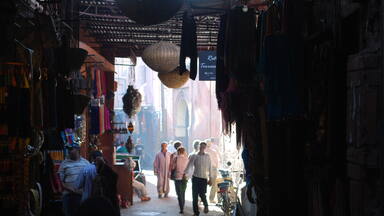


Protections
by other conservation instruments
1 protection / 2 elements
2003 Convention for the Safeguarding of the Intangible Cultural Heritage (2 elements)