Ilulissat Icefjord
Ilulissat Icefjord
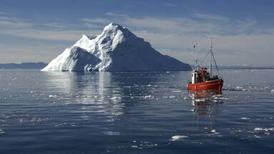
Located on the west coast of Greenland, 250 km north of the Arctic Circle, Greenland’s Ilulissat Icefjord is the sea mouth of Sermeq Kujalleq, one of the few glaciers through which the Greenland ice cap reaches the sea. Sermeq Kujalleq is one of the fastest and most active glaciers in the world. It annually calves over 35 km3 of ice, i.e. 10% of the production of all Greenland calf ice and more than any other glacier outside Antarctica. Studied for over 250 years, it has helped to develop our understanding of climate change and icecap glaciology. The combination of a huge ice-sheet and the dramatic sounds of a fast-moving glacial ice-stream calving into a fjord covered by icebergs makes for a dramatic and awe-inspiring natural phenomenon.
Description is available under license CC-BY-SA IGO 3.0
Fjord glacé d’Ilulissat
Situé sur la côte ouest du Groenland, à 250 km au nord du cercle arctique, le fjord glacé d’Ilulissat est l’embouchure maritime de Sermeq Kujalleq, un des rares glaciers à travers lesquels la glace de l’inlandsis groenlandais atteint la mer. Sermeq Kujalleq est l’un des glaciers les plus rapides et les plus actifs du monde. Son vêlage annuel de plus de 35 km3, soit 10 % de toute la glace de vêlage (les icebergs) du Groenland, dépasse celui de tous les autres glaciers du monde en dehors de l’Antarctique. Étudié depuis plus de 250 ans, le site a permis d’enrichir notre compréhension du changement climatique et de la glaciologie de la calotte glaciaire. L’immense couche de glace associée au fracas impressionnant d’une coulée de glace rapide vêlant dans un fjord couvert d’icebergs crée un phénomène naturel spectaculaire et grandiose.
Description is available under license CC-BY-SA IGO 3.0
خليج إيلوليسات الثلجي
يقع خليج إيلوليسات الثلجي عند الساحل الغربي لغروينلاند على مسافة250 كيلومتراً شمال المدار الشمالي وهو المنفذ البحري لسرمك كوجاليك، وهي من الخلجان الثلجيّة النادرة التي ينفذ بواسطتها ثلج المجلدة القارية في غروينلاند إلى البحر. وسرمك كوجاليك هو أحد أسرع المجلدات والأكثر نشاطاً في العالم. وينجرف منه سنويّاً أكثر من 35 كم³ أي 10% من مجموع جبال غروينلاند الثلجيّة ويتخطّى بهذه النسبة سائر المثلجات في العالم خارج القطب الجنوبي. وسمح هذا الموقع بعد مراقبة حركته مدّة 250 عام بتعزيز فهمنا للتغيّر المناخي وعلم ثلوج القطب الثلجيّة. ولا شكّ في أنّ الغطاء الثلجي المرفق بتحطّم ثلجي سريع المنجرف في خليجٍ مغطى بالجبال الجليديّة هو ظاهرة طبيعيّة رائعة وعظيمة.
source: UNESCO/CPE
Description is available under license CC-BY-SA IGO 3.0
伊路利萨特冰湾
格陵兰的伊路利萨特冰湾 位于格陵兰岛西岸,北极圈以北250公里,是少数几个通过格陵兰冰冠入海的冰河之一瑟梅哥-库雅雷哥(Sermeq Kujalleq)的出海口。瑟梅哥-库雅雷哥是世界上流速最快,也是最活跃的冰川之一,每年裂冰超过35立方公里,占格陵兰岛裂冰的10%,比南极洲以外的任何其他冰河都多。人们对这条冰湾的研究超过250年,冰湾有利于我们对气候变化和冰河学的了解。巨大的冰盖,加上冰流迅速移动,在冰山覆盖的峡湾内崩裂发出的巨响,形成了令人敬畏的自然现象。
source: UNESCO/CPE
Description is available under license CC-BY-SA IGO 3.0
Ледниковый фьорд Илулиссат (Гренландия)
Ледниковый фьорд площадью расположенный на западном побережье Гренландии в 250 км севернее Полярного круга – это один из нескольких ледниковых «языков», благодаря которым ледовый щит Гренландии достигает берега моря. Местный ледник (Sermeq Kujalleq), движущийся со скоростью, признан одним из самых быстрых в мире. Ежегодно от этого «языка» откалывается в море 35 кубокилометров льда, что составляет 10% от всей массы айсбергов, отходящих от Гренландии, и превосходит аналогичные показатели у любых других ледников, за исключением расположенных в Антарктике. Изучение этого фьорда на протяжении более 250 лет помогло лучше представить ход климатических изменений и понять особенности строения ледового щита Гренландии. Огромная масса льда, двигающаяся с оглушительным шумом и образующая айсберги, представляет собой грандиозное природное явление.
source: UNESCO/CPE
Description is available under license CC-BY-SA IGO 3.0
Fiordo helado de Ilulissat
Situado en la costa occidental de Groenlandia, a unos 250 km al norte del círculo polar ártico, el fiordo helado de Ilulissat es el lugar de desembocadura del Sermeq Kujalleq, uno de los pocos glaciares por los que la capa de hielo de esta inmensa isla septentrional se evacua hacia el mar. El Sermeq Kujalleq es uno de los glaciares más activos y rápidos del mundo, con una progresión de 19 metros diarios. Su volumen anual de evacuación de hielo es superior a 35 km3 y corresponde al 10% de la producida por todo el casquete de hielo de Groenlandia. De todos los glaciares existentes fuera del Antártico, el Sermeq Kujalleq es el que produce una mayor masa de icebergs. Las observaciones de que viene siendo objeto desde hace más de 250 años han permitido un mejor conocimiento de los cambios climáticos y la glaciología del casquete polar. Su inmensa masa de hielo, unida al inmenso estruendo que provoca su desplazamiento rápido hacia el mar en el fiordo lleno de icebergs, es un fenómeno de la naturaleza sobrecogedor y espectacular.
source: UNESCO/CPE
Description is available under license CC-BY-SA IGO 3.0
イルリサット・アイスフィヨルド
グリーンランドの西海岸に位置するイルリサットは、40万haにおよぶ地域であり、うち32万haが氷河、3万8600haがフィヨルドとなっている。セルメク・クジャレク氷河は、標高1200mから海まで連続した、世界でもたぐいまれな氷河である。この氷河から分離される氷の量は毎年40k㎡(グリーンランド全土から分離する氷の10%)にもおよび、南極大陸以外では最大量である。また、この氷河は世界でも最も速く(毎年7㎞)流れるものとして知られている。source: NFUAJ
IJsfjord Ilulissat
IJsfjord Ilulissat omvat en ligt aan de westkust van Groenland, 250 kilometer ten noorden van de poolcirkel. De fjord vormt de zeemond van Semeq Kujalleq, een van de weinige gletsjers waardoor de Groenlandse ijskap de zee bereikt. Sermeq Kujalleq is een van de snelste en actiefste gletsjers ter wereld. Meer dan 250 jaar studie naar dit gebied heeft bijgedragen aan het begrijpen van klimaatverandering en de ijskapglaciologie. De combinatie van een enorme ijskap en de dramatische geluiden van een snelle gletsjerijsstroom in een fjord van ijsbergen, maakt van dit gebied een indrukwekkend natuurverschijnsel.
Source: unesco.nl

Outstanding Universal Value
Brief synthesis
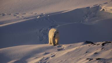
Located on the west coast of Greenland, 250 km north of the Arctic Circle, Greenland’s Ilulissat Icefjord is a tidal fjord covered with floating brash and massive ice, as it is situated where the Sermeq Kujalleq glacier calves ice into the sea. In winter, the area is frozen solid. One of the few places where ice from the Greenland ice cap enters the sea, Sermeq Kujalleq is also one of the fastest moving (40 m per day) and most active glaciers in the world. Its annual calving of over 46 cubic kilometres of ice, i.e. 10% of all Greenland calf ice, is more than any other glacier outside Antarctica, and it is still actively eroding the fjord bed. The combination of a huge ice-sheet and the dramatic sounds of a fast-moving glacial ice-stream calving into a fjord full of icebergs make for a dramatic and awe-inspiring natural phenomenon.
The Greenland ice cap is the only remnant in the Northern Hemisphere of the continental ice sheets from the Quaternary Ice Age. The oldest ice is estimated to be 250,000 years old, and provides detailed information on past climatic changes and atmospheric conditions from 250,000 to around 11,550 years ago, when climate became more stable. Studies made over the last 250 years demonstrate that during the last ice age, the climate fluctuated between extremely cold and warmer periods, while today the ice cap is being maintained by an annual accumulation of snow that matches the loss through calving and melting at the margins. This phenomenon has helped to develop our understanding of climate change and icecap glaciology.
Criterion (vii): The combination of a huge ice sheet and a fast moving glacial ice-stream calving into a fjord covered by icebergs is a phenomenon only seen in Greenland and Antarctica. Ilulissat offers both scientists and visitors easy access for a close view of the calving glacier front as it cascades down from the ice sheet and into the ice-choked fjord. The wild and highly scenic combination of rock, ice and sea, along with the dramatic sounds produced by the moving ice, combine to present a memorable natural spectacle.
Criterion (viii): The Ilulissat Icefjord is an outstanding example of a stage in the Earth’s history: the last ice age of the Quaternary Period. The ice-stream is one of the fastest (40 m per day) and most active in the world. Its annual calving of over 46 km3 of ice accounts for 10% of the production of all Greenland calf ice, more than any other glacier outside Antarctica. The glacier has been the object of scientific attention for 250 years and, along with its relative ease of accessibility, has significantly added to the understanding of ice-cap glaciology, climate change and related geomorphic processes.
Integrity
The property is of sufficient size to adequately represent the geological process of the ice fjord, i.e. the fast-moving ice-stream, the relevant portion of the inland icecap, the glacial front and the fjord. The boundaries of the property are clearly defined in relation to the logical topographic criteria of the natural watershed, and the settlements of the nearby villages of Ilimanaq and Ilulissat are excluded from the property. Along with climatic limitations and the fact that no roads exist at the site, the area’s physical features retain a high degree of natural integrity.
The property has effective legal protection and a sound planning framework, including the prohibition of any mining in the protected area. However, increased management will be required as pressures from tourism and resource harvesting continue to grow.
Protection and management requirements
The property is protected and conserved by an established framework of government legislation and protective designations and by local planning policies. The main legislative measure is the Greenland Parliament Act No. 29 of 18 December 2003 on nature protection. This act is the foundation framework for the protection of species, ecosystems and protected areas. Ilulissat itself is protected under the Greenland Home Rule Government Order No. 10 of 15 June 2007 on protection of Ilulissat Icefjord. The area bordering the property is further controlled by national regulations on waste disposal, use of snowmobiles, building constructions and landscape protection. Extensive hunting and fishing occurs in a portion of the property, and a special hunting law is enforced and monitored to ensure that the exploitation of biological resources in the area is sustainable. The property itself is managed cooperatively by a Board consisting of representatives from the Ministry of Environment and Nature and the Municipality of Ilulissat.
A comprehensive management plan has been developed and the property will benefit from a monitoring programme. Particular attention was paid to the rapidly increasing tourism in the area, and in particular pressures emanating from cruise ships visiting the site and helicopter traffic. Regulations concerning visits to the property by boat, foot, helicopter and dog sledge; the management of waste and waste disposal; building constructions; exploitation of biological resources in the area, and protection of the cultural heritage sites within the property have been put into place. Signage and visitor infrastructure have been upgraded, and a visitor centre in the town of Ilulissat is planned.
All land in the reserve is state-owned and no permanent settlements are allowed. Nearby construction is also strictly controlled. Visitor access to the area is limited by the wilderness character of the landscape, with no roads or human-made structures. Management issues such as crowding (from cruise tourism) and erosion are limited to a small area close to the town of Ilulissat. The protection of the property will be further enhanced when a planned buffer zone is adopted.


The Nomination files produced by the States Parties are published by the World Heritage Centre at its website and/or in working documents in order to ensure transparency, access to information and to facilitate the preparations of comparative analysis by other nominating States Parties.
The sole responsibility for the content of each Nomination file lies with the State Party concerned. The publication of the Nomination file, including the maps and names, does not imply the expression of any opinion whatsoever of the World Heritage Committee or of the Secretariat of UNESCO concerning the history or legal status of any country, territory, city or area or of its boundaries.