Montagnes dorées de l'Altaï
Situations géographiques multiples (3)
| ID | Nom & Situation | État partie | Coordonnées | Bien | Zone tampon |
|---|---|---|---|---|---|
| 768-001 | Altaisky Zapovednik and Buffer zone of Teletskoye Lake | Fédération de Russie |
N51 29 50.00 E87 42 40.00 |
965 753 ha | |
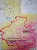
| 768-002 | Katunsky Zapovednik and Buffer zone around Belukha Mountain | Fédération de Russie |
N49 40 0.00 E86 0 0.00 |
392 800 ha | |
| 768-003 | Ukok Quiet Zone on the Ukok Plateau | Fédération de Russie |
N49 22 0.00 E87 30 0.00 |
252 904 ha |
Cartes
| Date | Titre | |
|---|---|---|
|
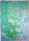
1997 | Teletskoye Lake and Altaisky zapovednik, scale: 1:500,000 |
|
1997 | Location of nominated clusters, scale: 1:1,600,000 |
Les dossiers de proposition d’inscription produits par les États parties sont publiés par le Centre du patrimoine mondial sur son site Internet et/ou dans des documents de travail afin de garantir la transparence, l’accès à l’information et de faciliter la préparation d’analyses comparatives par d’autres États parties soumissionnaires.
Le contenu de chaque dossier de proposition d’inscription relève de la responsabilité exclusive de l'État partie concerné. La publication d’un dossier de proposition d’inscription, y compris les cartes et les noms, ne saurait être interprétée comme exprimant une prise de position de la part du Comité du patrimoine mondial ou du Secrétariat de l'UNESCO à propos de l’histoire ou du statut juridique d'un pays, d'un territoire, d'une ville ou d'une zone, ou de ses frontières.