Gravures rupestres de Tanum
Rock Carvings in Tanum
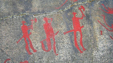
The rock carvings in Tanum, in the north of Bohuslän, are a unique artistic achievement not only for their rich and varied motifs (depictions of humans and animals, weapons, boats and other subjects) but also for their cultural and chronological unity. They reveal the life and beliefs of people in Europe during the Bronze Age and are remarkable for their large numbers and outstanding quality.
La description est disponible sous licence CC-BY-SA IGO 3.0
Gravures rupestres de Tanum
Dans le nord du Bohuslän, les gravures rupestres de la commune de Tanum constituent un ensemble de toute première importance sur le plan mondial, tant par leur variété (représentations humaines et animales, armes, bateaux et autres objets) que par leur unité culturelle et chronologique. Elles illustrent, avec une abondance et une qualité remarquables, la vie et les croyances de l'âge du bronze en Europe.
La description est disponible sous licence CC-BY-SA IGO 3.0
النقوش الصخرية في تانوم
تقع هذه النقوش الصخرية في منطقة تانوم شمال محافظة بوهوسلان وتشكل النموذج الأكثر أهمية في العالم بفضل تنوع مواضيعها (من رسوم لبشر وحيوانات وأسلحة وسفن واغراض اخرى) والوحدة الثقافية والزمنية التي تمثلها. كما انها تجسّد بوفرة وقيمة كبيرتين الحياة والمعتقدات التي سادت في العصر البرونزي في اوروبا.
source: UNESCO/CPE
La description est disponible sous licence CC-BY-SA IGO 3.0
塔努姆的岩刻画
塔努姆的岩刻画位于瑞典哥德堡以北,它丰富多彩的图形(描绘人类和动物、武器、船只和其他物品),表现了它独一无二的艺术成就和文化与年代的统一。它丰富突出的作品反映了欧洲青铜器时代人们的生活和信仰。
source: UNESCO/CPE
La description est disponible sous licence CC-BY-SA IGO 3.0
Наскальные рельефы в Тануме
Наскальные рельефы в Тануме на севере Бохуслена – это художественный шедевр, уникальный не только благодаря разнообразию сюжетов (изображения людей и животных, оружия, лодок и др.), но также из-за их культурной и хронологической целостности. Петроглифы отражают жизнь и верования людей бронзового века в Европе, и замечательны своим большим количеством и выдающимся качеством.
source: UNESCO/CPE
La description est disponible sous licence CC-BY-SA IGO 3.0
Grabados rupestres de Tanum
Situada al norte de la región de Bohuslän, la localidad de Tanum posee un conjunto de petroglifos de importancia excepcional tanto por su variedad –representaciones de seres humanos, animales, armas, embarcaciones y objetos diversos– como por su unidad cultural y cronológica. Estos grabados rupestres, que son ilustrativos de la vida y las creencias de los pueblos europeos en la Edad de Bronce, destacan por su abundancia y la calidad de su factura.
source: UNESCO/CPE
La description est disponible sous licence CC-BY-SA IGO 3.0
タヌムの線刻画群
source: NFUAJ
Rotstekeningen in Tanum
Source : unesco.nl

Valeur universelle exceptionnelle
Brève synthèse
Les roches gravées de Tanum, situées dans le nord de la province du Bohuslän à l’ouest de la Suède (comté de Västra Götaland), constituent un ensemble artistique de toute première importance par la richesse et la variété de leurs motifs (représentations humaines et animales, armes, bateaux et autres symboles) et par leur unité culturelle et chronologique. Elles représentent, avec une abondance et une qualité remarquables, la vie et les croyances des peuples du nord de l’Europe vivant à l’âge du bronze. L’utilisation continue des villages et la pratique permanente de l’agriculture sur plus de huit millénaires sont illustrées par cette collection d’art rupestre de l’âge du bronze qui donne à ce paysage culturel son caractère exceptionnel.
Le Bohuslän nord est une région au sous-sol granitique, dont une partie a été raclée il y a environ 14 000 ans lors du lent déplacement vers le nord de la calotte glaciaire scandinave, laissant à nu des roches légèrement incurvées. Ce sont les « toiles » choisies par les artistes de l’âge du bronze. Dans le Bohuslän nord, il existe au moins 1 500 sites connus où des roches gravées ont été découvertes. Ces gravures sont concentrées dans certaines zones, comme la paroisse de Tanum. Les gravures ont été réalisées en perforant et en broyant la roche à l’aide de marteaux et de pointes en pierre. Les panneaux d’art rupestre, créés habilement à l’aide d’outils sommaires, présentent une richesse et une variété de composition de la plus haute qualité, même si elles sont considérées simplement comme des œuvres d’art ou de création. Comparés à d’autres contextes similaires, ces motifs et scènes sont encore plus remarquables par leur capacité à transmettre des réflexions sur la vie et la cosmologie pendant l’âge du bronze nordique (de 1700 avant J.-C. à 500 après J.-C. environ). Ces panneaux, qui sont souvent situés sur des éminences dominant le paysage, ont manifestement pour intention de transmettre des messages, confirmant ainsi leur rôle de centres d’adoration et de culte, les premiers de leur époque.
Les roches gravées de Tanum constituent une réalisation artistique unique du fait de la précision et de l’adresse avec laquelle sont représentés animaux, êtres humains, vaisseaux, armes et symboles de l’âge du bronze. Des scènes souvent vivantes et des compositions complexes avec des motifs élaborés illustrent les thèmes du voyage, du statut social, du pouvoir, de la guerre et de la religion. Il apparaît évident que certaines de ces compositions, comme celle de Fossum, ont été mises en scène avant d’être réalisées. Pour la plupart, ces motifs, techniques et compositions apportent un témoignage exceptionnel sur la culture à l’âge du bronze en Europe.
Critère (i) : Les roches gravées de la région de Tanum constituent un exemple exceptionnel et de la plus haute qualité de l’art de l’âge du bronze.
Critère (iii) : La variété de motifs des roches gravées de Tanum apporte un témoignage exceptionnel sur de nombreux aspects de la vie à l’âge du bronze en Europe.
Critère (iv) : L’utilisation continue des villages et la pratique permanente de l’agriculture, illustrées par les roches gravées, les vestiges archéologiques ainsi que les éléments du paysage moderne de la région de Tanum contribuent à apporter la preuve d’une remarquable permanence pendant huit mille ans de l’histoire de l’homme.
Intégrité
On trouve dans les limites du bien qui couvre 4 137,609 ha tous les éléments nécessaires pour exprimer la valeur universelle exceptionnelle des gravures rupestres de Tanum, avec notamment plus de 600 sites de sculptures rupestres connus, soit la plus haute densité de ce type de gravures en Europe du Nord. L’intégrité et l’intégralité de cette zone sont illustrées dans la plaine centrale de Tanum, où l’on trouve à sa périphérie ouest et nord-est des sites de taille de roche. La grande majorité des villages connus et des cimetières préhistoriques sont situés aux confins nord et est de cette plaine. Les limites du bien assurent ainsi la représentation complète des caractéristiques et des processus qui expriment l’importance du bien. Aucune zone tampon n’a été définie.
D’une manière générale, le bien ne subit pas les répercussions négatives du développement et/ou de la négligence. Une partie importante des sculptures est bien conservée, même si plusieurs sites vulnérables continuent de se dégrader. L’amélioration de l’autoroute E6, qui traverse certaines parties du bien, était déjà prévue lors de l’inscription. Les autorités suédoises ont travaillé en accord avec le Centre du patrimoine mondial et l’ICOMOS et ont trouvé en 2009 une solution satisfaisante pour protéger les attributs qui sous-tendent la valeur universelle exceptionnelle du bien. Onze éoliennes situées à environ 5 km au nord-est du bien du patrimoine mondial ont été approuvées conformément à la législation suédoise et achevées en 2014. Des études indiquent que leur impact sur la valeur universelle exceptionnelle du bien est négligeable. Un parc éolien est prévu à environ 10 km au nord du bien du patrimoine mondial.
Authenticité
Les gravures rupestres de Tanum sont intégralement authentiques par leur emplacement et leur cadre, leurs formes et leurs dessins, leurs matériaux et leurs substances, ainsi que par leur esprit et leurs ambiances, comme le révèlent l’étude scientifique des sculptures et les analyses typologiques comparatives menées sur d’autres objets archéologiques de l’âge du bronze. L’authenticité s’exprime non seulement dans les panneaux eux-mêmes, mais dans le terrain adjacent, qui peut receler des preuves de rituels et d’autres pratiques liées à ceux-ci. Cette authenticité a été maintenue. L’utilisation sans interruption des terres avec la pratique continue de l’agriculture permet de comprendre l’emplacement des panneaux proches du niveau de la mer au moment de l’âge du bronze, ce qui renforce également l’authenticité du bien. À Tanum, comme dans le reste de la Scandinavie, les personnages de certains sites de gravures rupestres ont été repeints à plusieurs reprises au cours des cinq ou six dernières décennies, car il pouvait être difficile de les distinguer sur leur fond granitique. Aujourd’hui, seuls quelques panneaux exposés, soigneusement sélectionnés, sont peints avec une peinture non destructive par des spécialistes qualifiés. Des modifications de structures fondamentales dans l’agriculture pourraient menacer à l’avenir les qualités du paysage cultivé ouvert.
Éléments requis en matière de protection et de gestion
Les gravures rupestres de Tanum ont été désignées zone d’intérêt national et protégées à ce titre par le Code de l’environnement (2010) et la Loi sur l’aménagement et la construction (1987). La plus grande partie du bien comprend quelque 1 000 monuments individuels ou groupes de monuments protégés en vertu de la Loi sur le patrimoine culturel (1998). Toutes les roches gravées du bien sont situées sur des terres qui sont propriété privée, sauf une partie de celles de la ferme Vitlycke qui appartiennent au Musée des gravures rupestres de Vitlycke. En 2012, le Conseil de gestion a adopté un plan de gestion avec une vision et des objectifs pour la protection et la gestion du bien. Ce plan comprend un plan d’action, révisé tous les ans, qui est axé sur l’organisation, l’engagement accru de la population locale, le suivi, le tourisme durable et une documentation complète de tous les panneaux (qui devrait être achevée en 2020). Trois projets internationaux de recherche et de développement ainsi que des programmes complets d’enregistrement des dommages ont permis de constituer une base de connaissances, essentielle pour la mise en œuvre de futurs programmes de protection.
Pour conserver la valeur universelle exceptionnelle du bien sur le long terme, il conviendra de veiller à ce que le plan directeur municipal : continue de résoudre les problèmes posés par l’énergie éolienne, en empêchant notamment l’implantation d’éoliennes à l’intérieur du périmètre du bien du patrimoine mondial ; continue d’identifier les zones extérieures au bien sous l’angle des valeurs culturelles et naturelles du paysage dans son ensemble ; et continue d’examiner comment l’essor du tourisme durable pourrait contribuer au développement économique de la région. La création d’une aire de repos sur la nouvelle route E6, où l’on trouverait une introduction au bien du patrimoine mondial et des informations sur la région et l’augmentation de la capacité du Musée Vitlycke représentent des étapes importantes à cet égard. Le musée, et notamment la reconstitution d’une ferme de l’âge du bronze, joue un rôle important auprès des visiteurs, les aidant à déchiffrer les gravures rupestres et le paysage. Sa capacité en termes d’accueil et de gestion sera renforcée dans les années à venir. Les sites vulnérables en cours de dégradation devraient continuer à faire l’objet d’un suivi attentif, et toute dégradation devrait être corrigée conformément aux pratiques internationales agréées.
Liens


Les dossiers de proposition d’inscription produits par les États parties sont publiés par le Centre du patrimoine mondial sur son site Internet et/ou dans des documents de travail afin de garantir la transparence, l’accès à l’information et de faciliter la préparation d’analyses comparatives par d’autres États parties soumissionnaires.
Le contenu de chaque dossier de proposition d’inscription relève de la responsabilité exclusive de l'État partie concerné. La publication d’un dossier de proposition d’inscription, y compris les cartes et les noms, ne saurait être interprétée comme exprimant une prise de position de la part du Comité du patrimoine mondial ou du Secrétariat de l'UNESCO à propos de l’histoire ou du statut juridique d'un pays, d'un territoire, d'une ville ou d'une zone, ou de ses frontières.