| ID |
Nom & Situation |
État partie |
Coordonnées |
Bien |
Zone tampon |
|
1351-00
|
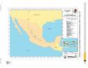
Historic centre of the city of México (World Heritage, 1987)
|
Mexique
|
N19 25 59.94
W99 7 58.59
|
910 ha
|
|
|
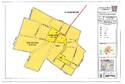
1351-001
|
Former college of San Francisco Javier in Tepotzotlán
|
Mexique
|
N19 42 47.99
W99 13 15.99
|
6,59 ha
|
40,59 ha
|
|
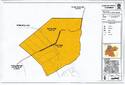
1351-002
|
Town of Aculco
|
Mexique
|
N20 5 57.93
W99 49 35.75
|
13,99 ha
|
42,03 ha
|
|
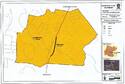
1351-003
|
Bridge of Atongo
|
Mexique
|
N19 59 11.99
W99 26 39.98
|
0,19 ha
|
63,22 ha
|
|
1351-004
|
Stretch of the Camino Real between Aculco and San Juan del Río
|
Mexique
|
N20 16 11.65
W99 53 11.52
|
|
7,58 ha
|
|
1351-005
|
Former convent of San Francisco in Tepeji del Río and bridge
|
Mexique
|
N19 54 16.78
W99 20 30.24
|
3,93 ha
|
107,52 ha
|
|
1351-006
|
Stretch of the Camino Real between the bridge of La Colmena and the Former hacienda of La Cañada
|
Mexique
|
N19 57 56.99
W99 22 41
|
6,31 ha
|
425,1 ha
|
|
1351-007
|
Historic centre of the city of San Juan del Río
|
Mexique
|
N20 23 22.97
W99 59 48.98
|
30,16 ha
|
137,31 ha
|
|
1351-008
|
Former hacienda of Chichimequillas
|
Mexique
|
N20 45 28.81
W100 20 32.31
|
7,56 ha
|
165,03 ha
|
|
1351-009
|
Chapel of the former hacienda of Buenavista
|
Mexique
|
N20 49 11.73
W100 28 3.57
|
0,05 ha
|
6,24 ha
|
|
1351-010
|
Historic centre of the city of Querétaro (World Heritage, 1996)
|
Mexique
|
N20 35 30.92
W100 23 24.67
|
400 ha
|
|
|
1351-011
|
Bridge of El Fraile
|
Mexique
|
N20 50 32.29
W100 47 45.07
|
0,25 ha
|
113,32 ha
|
|
1351-012
|
Former Royal hospital of San Juan de Dios of San Miguel de Allende
|
Mexique
|
N20 54 56.99
W100 44 54.97
|
0,93 ha
|
|
|
1351-013
|
Bridge of San Rafael
|
Mexique
|
N20 56 27.47
W100 47 37.3
|
0,58 ha
|
180,03 ha
|
|
1351-014
|
Bridge La Quemada
|
Mexique
|
N21 19 39.53
W101 5 46.5
|
1,49 ha
|
150,55 ha
|
|
1351-015
|
Protective town of San Miguel and Sanctuary of Jesús Nazareno de Atotonilco (World Heritage, 2008)
|
Mexique
|
N20 54 50.2
W100 44 37.55
|
43,26 ha
|
84,79 ha
|
|
1351-016
|
Historic centre of the city of Guanajuato and its adjacent mines (World Heritage, 1988)
|
Mexique
|
N21 1 0.99
W101 15 20
|
190 ha
|
|
|
1351-017
|
Historic centre of the city of Lagos de Moreno and bridge
|
Mexique
|
N21 21 28.78
W101 55 41.65
|
29,08 ha
|
92,25 ha
|
|
1351-018
|
Historic ensemble of the Town of Ojuelos
|
Mexique
|
N21 52 0.18
W101 35 37.38
|
0,82 ha
|
42,62 ha
|
|
1351-019
|
Bridge of Ojuelos
|
Mexique
|
N21 48 19
W101 45 30.98
|
1,29 ha
|
200,27 ha
|
|
1351-020
|
Former hacienda of Ciénega de Mata
|
Mexique
|
N21 44 33.85
W101 49 39.18
|
2,49 ha
|
35,11 ha
|
|
1351-021
|
Cemetery in Encarnación de Díaz
|
Mexique
|
N21 31 53.55
W102 14 13.68
|
1,64 ha
|
16,88 ha
|
|
1351-022
|
Former hacienda of Peñuelas
|
Mexique
|
N21 42 38.99
W102 16 55.99
|
8,65 ha
|
369,25 ha
|
|
1351-023
|
Former hacienda of Cieneguilla
|
Mexique
|
N21 43 0
W102 26 51
|
3 ha
|
516,46 ha
|
|
1351-024
|
Historic ensemble of the city of Aguascalientes
|
Mexique
|
N21 52 50
W102 17 47.99
|
6,45 ha
|
79,23 ha
|
|
1351-025
|
Former hacienda of Pabellón de Hidalgo
|
Mexique
|
N22 10 28.99
W102 20 29
|
10,72 ha
|
180,4 ha
|
|
1351-026
|
Chapel of San Nicolás Tolentino of the former hacienda of San Nicolás de Quijas
|
Mexique
|
N22 9 12.6
W101 42 25.85
|
0,11 ha
|
9,65 ha
|
|
1351-027
|
Town of Pinos
|
Mexique
|
N22 17 55.36
W101 34 30.49
|
3,35 ha
|
14,18 ha
|
|
1351-028
|
Temple of Nuestra Señora de los Ángeles of the town of Noria de Ángeles
|
Mexique
|
N22 26 35.7
W101 54 35.86
|
0,15 ha
|
2,71 ha
|
|
1351-029
|
Temple of Nuestra Señora de los Dolores in Villa González Ortega
|
Mexique
|
N22 30 44.33
W101 54 49.88
|
0,15 ha
|
5,16 ha
|
|
1351-030
|
Former college of Nuestra Señora de Guadalupe of Propaganda Fide
|
Mexique
|
N22 44 45.97
W102 31 5.99
|
2,75 ha
|
17,53 ha
|
|
1351-031
|
Historic ensemble of the city of Sombrerete
|
Mexique
|
N23 37 54
W103 38 22.97
|
3,79 ha
|
39,14 ha
|
|
1351-032
|
Temple of San Pantaleón Mártir in the Town of Noria de San Pantaleón
|
Mexique
|
N23 39 15.89
W103 46 21.51
|
0,21 ha
|
19,76 ha
|
|
1351-033
|
Sierra de Órganos (Mountain Range of Órganos)
|
Mexique
|
N23 51 46.89
W103 50 50.92
|
1 124,65 ha
|
4 770,6 ha
|
|
1351-034
|
Architectonic ensemble of the Town of Chalchihuites
|
Mexique
|
N23 28 38.3
W103 53 3
|
1,83 ha
|
16,04 ha
|
|
1351-035
|
Stretch of the Camino Real between Ojocaliente and Zacatecas
|
Mexique
|
N22 39 40.22
W102 23 3.46
|
6,76 ha
|
1 941,02 ha
|
|
1351-036
|
Cave of Ávalos
|
Mexique
|
N22 36 29
W102 22 45
|
3,28 ha
|
98,18 ha
|
|
1351-037
|
Historic centre of the city of Zacatecas (World Heritage, 1993)
|
Mexique
|
N22 46 29.54
W102 34 24.02
|
110 ha
|
|
|
1351-038
|
Sanctuary of Plateros
|
Mexique
|
N23 13 44
W102 50 25.98
|
0,2 ha
|
2,45 ha
|
|
1351-039
|
Historic centre of the city of San Luis Potosí
|
Mexique
|
N22 9 4.53
W100 58 28.36
|
70,34 ha
|
133,49 ha
|
|
1351-040
|
Chapel of San Antonio of the Former hacienda of Juana Guerra
|
Mexique
|
N23 50 33.3
W104 11 22.61
|
0,63 ha
|
32,69 ha
|
|
1351-041
|
Temples in the town of Nombre de Dios
|
Mexique
|
N23 50 57.98
W104 14 40.97
|
5,94 ha
|
109,96 ha
|
|
1351-042
|
Former hacienda of San Diego de Navacoyán and Puente del Diablo (Devil’s Bridge)
|
Mexique
|
N24 2 36.97
W104 32 56.99
|
0,98 ha
|
352,32 ha
|
|
1351-043
|
Historic centre of the city of Durango
|
Mexique
|
N24 1 28.99
W104 40 13
|
48,03 ha
|
394,81 ha
|
|
1351-044
|
Temples in the town of Cuencamé and Cristo de Mapimí
|
Mexique
|
N24 52 12
W103 41 52.98
|
2,63 ha
|
43,51 ha
|
|
1351-045
|
Chapel of the Refugio of the former hacienda of Cuatillos
|
Mexique
|
N25 5 45.63
W103 46 22.47
|
0,3 ha
|
56,82 ha
|
|
1351-046
|
Temple of the town of San José de Avino
|
Mexique
|
N24 31 25.24
W104 17 57.76
|
0,19 ha
|
5,39 ha
|
|
1351-047
|
Chapel of the former hacienda of La Inmaculada Concepción de Palmitos de Arriba
|
Mexique
|
N25 2 14.66
W104 28 48.75
|
0,03 ha
|
2,75 ha
|
|
1351-048
|
Chapel of the former hacienda of La Limpia Concepción de Palmitos de Abajo (Huichapa)
|
Mexique
|
N25 4 35
W104 29 57.98
|
0,03 ha
|
2,71 ha
|
|
1351-049
|
Architectonic ensemble of the Town of Nazas
|
Mexique
|
N25 13 33.99
W104 6 51.54
|
5,06 ha
|
181,51 ha
|
|
1351-050
|
Town of San Pedro del Gallo
|
Mexique
|
N25 33 56.99
W104 17 33.99
|
4,27 ha
|
9,8 ha
|
|
1351-051
|
Architectonic ensemble of the Town of Mapimí
|
Mexique
|
N25 50 0.97
W103 50 52.98
|
2,87 ha
|
41,01 ha
|
|
1351-052
|
Town of Indé
|
Mexique
|
N25 54 47.99
W105 13 23
|
1,85 ha
|
9,28 ha
|
|
1351-053
|
Chapel of San Mateo of the Former hacienda of La Zarca
|
Mexique
|
N25 50 40.97
W104 44 29.99
|
0,17 ha
|
198,34 ha
|
|
1351-054
|
Former hacienda of the Limpia Concepción of El Canutillo
|
Mexique
|
N26 22 58
W105 22 8
|
0,83 ha
|
34,35 ha
|
|
1351-055
|
Temple of San Miguel of the town of Villa Ocampo
|
Mexique
|
N26 26 24
W105 30 33.99
|
0,2 ha
|
7,93 ha
|
|
1351-056
|
Stretch of the Camino Real between Nazas and San Pedro del Gallo
|
Mexique
|
N25 22 41
W104 8 38.99
|
|
256 272,88 ha
|
|
1351-057
|
Mine of Ojuela
|
Mexique
|
N25 47 33.98
W103 47 26.97
|
9,98 ha
|
56,85 ha
|
|
1351-058
|
Cave of Las Mulas de Molino
|
Mexique
|
N24 44 27.97
W105 0 26.97
|
0,66 ha
|
4,58 ha
|
|
1351-059
|
Town of Valle de Allende
|
Mexique
|
N26 56 21.98
W105 23 38
|
10,26 ha
|
158,65 ha
|