Systèmes d’irrigation aflaj d’Oman
Situations géographiques multiples (5)
| ID | Nom & Situation | État partie | Coordonnées | Bien | Zone tampon |
|---|---|---|---|---|---|
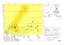
| 1207-001 | Falaj Al-Katmeen | Oman |
N22 55 60.00 E57 40 0.00 |
135,028 ha | 1 756,4 ha |
| 1207-002 | Falaj Al-Malki | Oman |
N22 43 60.00 E57 46 0.00 |
600 ha | 4 255,71 ha |
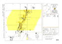
| 1207-003 | Falaj Daris | Oman |
N22 58 60.00 E57 31 60.00 |
389,468 ha | 3 370,1 ha |
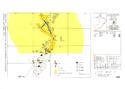
| 1207-004 | Falaj Al-Jeela | Oman |
N22 46 60.00 E59 10 0.00 |
30,952 ha | 3 839,46 ha |
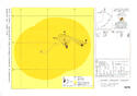
| 1207-005 | Falaj Al-Muyasser | Oman |
N23 21 0.00 E57 27 0.00 |
300,501 ha | 3 182,66 ha |
Cartes

Les dossiers de proposition d’inscription produits par les États parties sont publiés par le Centre du patrimoine mondial sur son site Internet et/ou dans des documents de travail afin de garantir la transparence, l’accès à l’information et de faciliter la préparation d’analyses comparatives par d’autres États parties soumissionnaires.
Le contenu de chaque dossier de proposition d’inscription relève de la responsabilité exclusive de l'État partie concerné. La publication d’un dossier de proposition d’inscription, y compris les cartes et les noms, ne saurait être interprétée comme exprimant une prise de position de la part du Comité du patrimoine mondial ou du Secrétariat de l'UNESCO à propos de l’histoire ou du statut juridique d'un pays, d'un territoire, d'une ville ou d'une zone, ou de ses frontières.