Asmara: A Modernist African City (Eritrea)
UNESCO Urban Heritage Atlas: Cultural mapping of historic cities and settlements
"Located at over 2,000 m above sea level, the capital of Eritrea developed from the 1890s onwards as a military outpost for the Italian colonial power. It is an exceptional example of early modernist urbanism at the beginning of the 20th century and its application in an African context."
Historic building attributes
The significant expansion after 1935 applied the Italian modernist idioms of the time to a variety of buildings. As a result, the buildings attest to the interchanges and cultural assimilation between different cultures, as well as the role of Asmara in building a collective identity.
Institutional buildings
The monumental civic buildings are located in pivotal points of the urban tissue, and tree rows (here layed on a 5m module) reinforce their perception and characterise the public space.
Places of culture
Asmara has an extraordinary amount of cultural buildings, such as cinemas and theatres, which show the features of rationalist architecture. The co-existence of heterogeneous buildings illustrates the populations' diversity and rituals.
Religious buildings
The religious buildings of Asmara reflect different architectural styles and construction techniques, as well as the diversity and multiculturality present in the city.
For instance, the Catholic Cathedral Our Lady of the Rosary is an example of neo-romanesque architecture in Eastern Africa, dating back to 1923, the late liberal period of occupation.
The Enda Mariam (St Mary) Orthodox Cathedral, built in 1938, integrates local traditional construction techniques, especially on the façade, as well as modernist elements.
Attributes of urban elements
After 1935, Asmara underwent a large-scale construction programme, following the Italian modernist style of architecture and planning. Today, the city's area resulted from various planning phases between 1893 and 1941, is protected as a World Heritage property, as well as the indigenous neighbourhoods of Arbate Asmera and Abbashawel.
The urban layout is based on an orthogonal grid which later integrated radial elements. The different planning phases are recognisable by the different urban patterns, which adapt modern urban planning and architectural models to local cultural and geographical conditions.
© David Stanley, CC BY 2.0 via Flickr
"Asmara’s urban character and strong urban form exhibit a human scale in the relationship between buildings, streets, open spaces, and related activities adapted to the local conditions, which embodies both colonial and post-colonial African life, with its public spaces, mixed-use fabric and place-based material culture."
Skyline
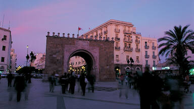
The urban landscape testifies to Asmara's heritage of tolerance and religious diversity. The bell tower of the Catholic Cathedral (1923) and the minaret of the Grand Mosque (1938) appear behind the towers flanking access to the Orthodox Cathedral.
Streets
Wide boulevards, generally flanked by three- to four-storey buildings, convey the human scale that characterises Asmara's public space. This urban attribute outlived the post-colonial turmoil due to the absence of urban clashes and the limited city development.
Interactive mapping
Use the interactive mapping tool to explore the different layers that compose Asmara's urban heritage. Browse through the tabs to navigate through the different scales of the city and the attributes of its urban heritage identity. Expand the legend on the bottom right corner to discover more. Click on the areas and icons to open pop-ups and learn more about the different elements.
Attributes of the wider setting of the city or settlement
Located at over 2,300 m above sea level, among the highest world capitals, Asmara developed from the 1890s onwards as a military outpost for the Italian colonial power. The city is located in the highlands, inland from Massawa, the country's former capital on the coast of the Red Sea.
"Asmara is situated on the central plateau of the Eritrean Highlands at the edge of the eastern escarpment. The northeastern part of the city is surrounded by wonderful hilly natural landscapes. The tailor-made urban plan of Asmara has a strong relationship with these topographic and landscape features. The combination of the geographical context, urban plans and modernist architecture created a unique urban landscape."
Intangible heritage values
"Eritrea has nine ethnic groups with different cultural norms, languages and religions. These ethnic groups have lived in the historic city in harmony and tolerance for centuries. Asmara, which plays a vital role in the country's political, socio-economic and cultural development, serves as a cross-fertilisation of different cultures and a "melting pot". As a result, the various ethnic groups have formed vibrant communities that are custodians of their heritage values and aspirations. The communities are involved in the conservation and management of the city in different ways, such as consultation during the preparation of the conservation master plan and World Heritage management plan. Asmara's inhabitants love their city, seen as a symbol of their unity and identity, as well as the social meaning and values embodied in the spirit of the place or genius loci."
Asmara has retained the authenticity of local intangible attributes such as language, cultural practices, identity and sense of place. The city has evolved from an indigenous economic and administrative centre to a colonial city and now to a modern African capital while preserving the city's artistic, material and functional attributes. Elements of the city's living heritage include social practices such as harmony, tolerance, inclusiveness, hospitality and co-existence among different ethnic groups, as well as cultural expressions such as traditional craftmanship and performing arts, which take place in the numerous theatres and cinemas of the capital.
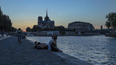
"Asmara's street life is very lively: the city's inhabitants have a strong tradition of strolling along main avenues and streets, known as "La Passeggiata”. The streets and public spaces are places of walking, music and dancing, as well as festivities, parades, celebrations, street markets and outdoor cafe activities."
References
- Asmara Heritage Project (AHP). (2015). Asmara Proposed World Heritage Site Integrated Management Plan 2016-2021. whc.unesco.org/document/155765.
- ICOMOS. (2017). Advisory Body Evaluation. whc.unesco.org/document/159755
- World Heritage Committee, 41th session. (2017). Decision 41COM 8B.11. whc.unesco.org/en/decisions/6883.
- World Heritage Nomination Dossier 1550, including Executive Summary, Nomination Text, Annexes, Maps, and Management Plan. (2017). whc.unesco.org/fr/list/1550/documents/.
Links
© UNESCO, 2023.
Project team: Jyoti Hosagrahar, Mirna Ashraf Ali, Alba Zamarbide, Carlota Marijuan Rodriguez, Giacomo Martinis, Marta Zerbini.
* Illustrations marked with an asterisk have all rights reserved. Permission is required for their reuse.


 Eritrea
Decisions / Resolutions (2)
The World Heritage Committee,
- Having examined Documents WHC/18/42.COM/8B.Add, WHC/18/42.COM/INF.8B1.Add and WHC/18/42.COM/INF.8B2.Add,
- Recalling Decision 41 COM 8B.9 adopted at its 41st session (Krakow, 2017);
- Inscribes Tehuacán-Cuicatlán Valley: originary habitat of Mesoamerica, Mexico, on the World Heritage List on the basis of criterion (iv) and (x);
- Takes note of the following provisional Statement of Outstanding Universal Value:
Brief synthesis
The Tehuacán-Cuicatlán: originary habitat of Mesoamerica is located in central-southern Mexico, at the southeast of the State of Puebla and north of the State of Oaxaca. The property is a serial site of some 145,255 ha composed of three components: Zapotitlán-Cuicatlán, San Juan Raya and Purrón. All these share the same buffer zone of some 344,932 ha. The entire property is located within the Tehuacán-Cuicatlán Biosphere Reserve. The property coincides with a global biodiversity hotspot and lies within an arid or semiarid zone with one of the highest levels of biological diversity in North America, giving rise to human adaptations crucial to the emergence of Mesoamerica, one of the cradles of civilisation in the world.
Of the 36 plant communities, 15 different xeric shrublands are exclusive to the Tehuacán-Cuicatlán Valley. The valley includes representatives of a remarkable 70% of worldwide flora families and includes over 3,000 species of vascular plants of which 10% are endemic to the Valley. It is also a global centre of agrobiodiversity and diversification for numerous groups of plants, in which the cacti stand out, with 28 genera and 86 species of which 21 are endemic. Large “cacti-forests” shape some landscapes of the Valley making it one of the most unique areas in the world.
The property exhibits the impressively high levels of faunal diversity known in this region including very high levels of endemism among mammals, birds, amphibians and fish. It also hosts an unusually high number of threatened species with some 38 listed under the IUCN Red List of Threatened Species. The property is one of the richest protected areas in Mexico in terms of terrestrial mammals (134 species registered, two of them endemic to the Valley). The Tehuacán-Cuicatlán Valley is part of the Balsas Region and Interior Oaxaca Endemic Bird Area (EBA). There are 353 bird species recorded, of which nine are endemic to Mexico. The property has eight known roosting areas of the threatened Green Macaw including a breeding colony.
The vast biodiversity of the Valley, combined with the adverse conditions of a desert, gave rise to one of the largest and best documented cultural sequences in the Americas. The archaeological evidence reveals the long sequence of human adaptations that took place in the area for over 14,000 years. The Tehuacán-Cuicatlán Valley is an exceptional example of a long process of adaptations and ancient technological evolution that defined the cultural region known today as Mesoamerica.
The arid conditions of the Valley triggered innovation and creativity, originating two of the major technological advances of human history: 1) plant domestication, which in the Valley is one of the most ancient worldwide, dating back to 9500 to 7000 B.C., and 2) development of water management technologies resulting in a wide array of water management elements, such as canals, wells, terraces, aqueducts and dams which make it the most diversified ancient irrigation complex of the continent. Consequently, water management technological features were the ruling guide for the civilisational process that was developed in the Valley throughout thousands of years. Furthermore, these technological advances had a multiplying effect and fostered the discovery of other innovations like salt industry and pottery, which were essential to the organisation and complexity of the first civilisations.
The Tehuacán-Cuicatlán Valley: originary habitat of Mesoamerica is an invaluable and irreplaceable heritage of humanity and of all living things.
Criterion (iv): The technological ensemble of water management of the Tehuacán-Cuicatlán Valley, along with other archaeological evidences such as the remains found in caves, plant domestication sites and agriculture, use of wild species, salt ponds and pottery, mark a stage of the utmost importance for the Mesoamerican region: the appearance and development of one of the oldest civilisations in the world. Located throughout the Valley, these technologies bear unique evidence of the constant adaptation of humans to the environment and reflect their innovative capacity to face the adverse environmental conditions in the area.
Criterion (x): The Tehuacán-Cuicatlán Valley demonstrates exceptional levels of biological diversity in an arid and semiarid zone in North America. A remarkable 70% of worldwide floral families are represented in the Valley, by at least one species, and the area is one of the main centres of diversification for the cacti family, which is highly threatened worldwide. A remarkable diversity of cacti exists within the property often in exceptional densities of up to 1,800 columnar cacti per hectare. The property exhibits particularly high diversity among other plant types, namely the agaves, yuccas, bromeliads, bursera and oaks. Worldwide, it hosts one of the highest animal biodiversity levels in a dryland, at least with regard to taxa such as amphibians, reptiles and birds. The property coincides with one of the most important protected areas worldwide for the conservation of threatened species encompassing over 10% of the global distribution range of four amphibian species, and is ranked as the one of the two most important protected areas in the world for the conservation of seven amphibian and three bird species. The biodiversity of this region has a long history of sustaining human development and today a third of the total diversity of the Tehuacán-Cuicatlán Valley, some 1,000 species, are used by local people.
Integrity
The property is of sufficient overall size and contains the key representative habitats and plant communities of the floristic province Tehuacán-Cuicatlán and all the relevant cultural elements that convey its Outstanding Universal Value. The three components include relatively undisturbed areas of high conservation value and the 22 selected archaeological sites, and are embedded within a larger buffer zone all of which coincides with the Tehuacán-Cuicatlán Biosphere Reserve. Further protection is afforded by the biosphere reserve’s larger transitional zone. The management systems in place address the various threats to the area and establish objectives, strategies and specific actions in coordination with key local, national and international stakeholders to address these threats including any adverse effects of development.
Authenticity
The component sites still maintain their original condition, with the obvious weathering effects of time over millennia, but without any major disturbance in their main attributes. Investigations by renowned national and international academics have been based mainly in carbon and sediment dating, as well as the study and dating of clay remains considered relevant to determine the time limits of the sites. Thanks to the investigation methods used, the sites are still unaltered and so the spiritual character inherent to each one of them and to the system of sites as a whole has been preserved.
Protection and management requirements
The property Tehuacán-Cuicatlán Valley: originary habitat of Mesoamerica has effective legal protection to ensure the maintenance of its Outstanding Universal Value. At the time of inscription the property has a recently updated Strategic Management Plan which aims to integrate the management of natural heritage with archaeological features through a series of interrelated objectives. The plan provides a description of natural and cultural assets within the framework of a mixed World Heritage property and prescribes additional measures for the conservation and management of intangible cultural heritage, such as linguistic diversity and communities’ sustainable development.
The institutions in charge of implementing protective measures are the Ministry of Environment and Natural Resources, the National Commission of Natural Protected Areas (CONANP), the Federal Attorney General for Environmental Protection and the National Institute of Anthropology and History (INAH). For monitoring of biodiversity the National Commission for Knowledge and Use of Biodiversity and the National Forestry Commission coordinate with CONANP. All these institutions work together with the Administration Office of the Tehuacán-Cuicatlán Biosphere Reserve. Ongoing efforts are needed to ensure full integration and institutional coordination across issues related to natural and cultural heritage in accordance with the respective mandates of CONANP and INAH. Both managing institutions are committed to actively working with local communities and efforts to strengthen these approaches are ongoing.
In comparison to other regions, current and potential threats are considered quite low, and the population density is low. Tourism use at time of inscription is relatively minimal, however, has the potential to rapidly grow. A Nature Tourism Strategy for the Tehuacán-Cuicatlán Biosphere Reserve (2018-2023) seeks to balance the protection of the property’s Outstanding Universal Value with fostering responsible visitation that empowers local communities. Priority needs to be given to the adaptive implementation of this strategy based on monitoring the impacts.
- Requests the State Party to:
- Conduct a more systematic inventory of fauna and flora within the property and the wider biosphere reserve and Tehuacán-Cuicatlán Valley to guide opportunities for further extension of the property,
- Continue to strengthen participatory governance arrangements which work with local communities in harnessing tangible benefits from the World Heritage property;
- Welcomes the improved integration of natural aspects with archaeological features within the updated Strategic Management Plan for the Cultural Sites within the property which complements the actions set forth in the Management Programme of the Tehuacán-Cuicatlán Biosphere Reserve and encourages continued harmonization between natural and cultural heritage management;
- Also welcomes the updated Nature Tourism Strategy for the Tehuacán-Cuicatlán Biosphere Reserve (2018-2023) which seeks to balance the protection of the property’s Outstanding Universal Value while fostering responsible visitation that empowers local communities and also encourages the State Party to implement the strategy including the envisaged infrastructure, long-term impact monitoring, and tourism-related capacity building for local communities;
- Further encourages the State Party to:
- Continue to undertake further surveys, research and documentation of cultural heritage sites in the Tehuacán-Cuicatlán Valley, including in areas currently located outside the property boundaries, related to irrigation systems and settlements to further clarify the attributes that contribute to the Outstanding Universal Value of the property and to identify whether these are in the property. If these are located out of the property, to consider a minor boundary modification to include these,
- Complete the legal protection of the relevant cultural heritage resources to be recognized at highest levels appropriate, including the full recognition at national level of the sites presently proposed,
- Further detail the envisaged implementation of management, research and monitoring activities for cultural heritage within the strategic management plan, integrating also conservation and maintenance as well as visitor management provisions,
- Strengthen the overall human and financial resources for management of cultural assets within the Tehuacán-Cuicatlán Valley.
The World Heritage Committee,
- Having examined Documents WHC/17/41.COM/8B and WHC/17/41.COM/INF.8B1,
- Inscribes Asmara: Africa’s Modernist City, Eritrea, on the World Heritage List on the basis of criteria (ii) and (iv);
- Adopts the following Statement of Outstanding Universal Value:
Brief synthesis
Located on an highland plateau at the centre of Eritrea, Asmara, a Modernist city of Africa is the capital of the country and is an exceptionally well-preserved example of a colonial planned city, which resulted from the subsequent phases of planning between 1893 and 1941, under the Italian colonial occupation. Its urban layout is based mainly on an orthogonal grid which later integrated elements of a radial system. Asmara preserves an unusually intact human scale, featuring eclectic and rationalist built forms, well-defined open spaces, and public and private buildings, including cinemas, shops, banks, religious structures, public and private offices, industrial facilities, and residences. Altogether, Asmara’s urban-scape outstandingly conveys how colonial planning, based on functional and racial segregation principles, was applied and adapted to the local geographical conditions to achieve symbolic meaning and functional requirements. The town has come to be associated with the struggle of the Eritrean people for self-determination, which was pursued whilst embracing the tangible, yet exceptional, evidence of their colonial past.
Asmara’s urban character and strong urban form exhibits a human scale in the relationship between buildings, streets, open spaces, and related activities adapted to the local conditions, which embodies both colonial and post-colonial African life, with its public spaces, mixed-use fabric and place-based material culture. These spaces and use patterns also bear witness to interchange and cultural assimilation of successive encounters with different cultures as well as to the role played by Asmara in building a collective identity that was later instrumental in motivating early efforts for its preservation. Asmara’s urban layout with its different patterns associated to the planning phases, illustrates the adaptation of the modern urban planning and architectural models to local cultural and geographical conditions. The ensembles attesting to the colonial power and to the presence of a strong and religiously diverse local civic society, with its institutional and religious places, the elements of the urban architecture (Harnet et Sematat avenues; Mai Jah Jah park; the walking paths; the old plaques with traces of the street names), the buildings, complexes and facilities resulting from the 1930s programmes (the post office building at Segeneyti Street), the cinemas (Impero, Roma, Odeon, Capitol, Hamasien), the schools, the sport facilities, the garages, the residential complexes and buildings, the villas, the commercial buildings, the factories; the cores of the community quarters (e.g. the Italian quarter and market square and mosque square); the major religious buildings, marking the landscape with bell-towers, spires, and minarets, and the civil and military cemeteries which illustrate the diversity of the populations and of their rituals.
Criterion (ii): Asmara, a Modernist City of Africa, represents an outstanding example of the transposition and materialization of ideas about planning in an African context and were used for functional and segregation purposes. The adaptation to the local context is reflected in the urban layout and functional zoning, and in the architectural forms, which, although expressing a modernist and rationalist idiom, and exploiting modern materials and techniques, also relied on and borrowed heavily from local morphologies, construction methods, materials, skills and labour. Asmara’s creation and development contributed significantly to Eritrea’s particular response to the tangible legacies of its colonial past. Despite the evidence of its colonial imprint, Asmara has been incorporated into the Eritrean identity, acquiring important meaning during the struggle for self-determination that motivated early efforts for its protection.
Criterion (iv): Asmara’s urban layout and character, in combining the orthogonal grid with radial street patterns, and picturesque elements integrating topographical features, taking into account local cultural conditions created by different ethnic and religious groups, and using the principle of zoning for achieving racial segregation and functional organisation, bears exceptional witness to the development of the new discipline of urban planning at the beginning of the 20th century and its application in an African context, to serve the Italian colonial agenda. This hybrid plan, that combined the functional approach of the grid with the picturesque and the creation of scenic spaces, vistas, civic plaza and monumental places, served the functional, civic and symbolic requirements for a colonial capital. The architecture of Asmara complements the plan and forms a coherent whole, although reflecting eclecticism and Rationalist idioms, and is one of the most complete and intact collections of modernist/rationalist architecture in the world.
Integrity
All the significant architectural structures and the original urban layout, including most of the characteristic features and public spaces, have been retained in their entirety. The site has also preserved its historical, cultural, functional and architectural integrity with its elements largely intact and generally in relatively acceptable condition, although a number of buildings suffer from lack of maintenance. Limited negative impacts have been the occasional inappropriate restoration of older structures and the construction of some buildings in the late 20th century that are inappropriate in size, scale or character. Despite continuing developmental pressures, the establishment of the ‘Historic Perimeter’ around the centre of the city since 2001 and a moratorium on new construction within this perimeter by the municipal authorities have safeguarded the site’s integrity.
The integrity of the intangible attributes associated with the local community that has inhabited parts of the site for centuries has been maintained through a process of cultural continuity that, despite successive waves of foreign influence, has been successfully assimilated into a modern national consciousness and a national capital.
Authenticity
Asmara’s combination of innovative town planning and modernist architecture in an African context represents important and early developmental phases of town planning and architectural modernism that are still fully reflected in its layout, urban character and architecture.
Climatic, cultural, economic and political conditions over subsequent decades have favoured the retention of the artistic, material and functional attributes of the city’s architectural elements to an almost unique degree of intactness, which allows also for future research on the history of construction of its buildings.
The authenticity of local intangible attributes manifested in language, cultural practices, identity, and sense of place have been retained through Asmara’s evolution from an indigenous centre of economy and administration, through a colonial capital, to a modern African capital.
Protection and management requirements
The protection of Asmara has been granted by the Regolamento Edilizio 1938, issued at the time of Cafiero’s plan, and by the moratorium on new construction issued in 2001. The Cultural and Natural Heritage Proclamation 2015 provides conditions for the legal protection of the property through ad-hoc designations. The Asmara Heritage Project and the Department of Public Works Development hold responsibilities for issuing building permits and granting permission for maintenance works in compliance with existing regulations. Planning instruments at different scales are crucial in complementing the legal protection of Asmara and its setting and in guaranteeing its effective management: the Urban Conservation Master Plan and the related Asmara Planning Norms and Technical Regulations under development are key tools in this regard. Both need to ensure that the intactness of Asmara’s urban and built fabric, its human scale and specific modernist yet African character, are preserved, though favouring proactive maintenance, conservation and rehabilitation of its urban fabric and spaces. Given the several administrative/technical structures and instruments already in place, the envisaged management framework needs to build on existing experiences and structures and ensure coordination and clear mandates, which avoid duplication.
- Recommends that the State Party give consideration to the following:
- Issuing the specific protective designations for the property as per the provisions of the Cultural and Natural Heritage Proclamation 2015 and developing an implementation calendar to monitor advancements in this regard,
- Finalising the Urban Conservation Master Plan and the Asmara Planning Norms and Technical Regulations, making consistent the zoning in the relevant plan and regulations, taking into account the 15 zones of the urban analysis, and developing action plans with clear priorities for conservation intervention and budget proposals,
- Developing strategies to ensure a steady influx of financial resources, including loans and tax reduction or exemption measures, substantial qualified human resources, and considerable institutional and technical capacity,
- Setting up the central management body envisaged by the Integrated Management Plan, based on the existing capacities and functioning structures, and giving it the function to coordinate all relevant stakeholders, both public and private, acting within the property and its buffer zone and providing it with the necessary technical and financial means and adequate human resources;
- Requests the State Party to submit to the World Heritage Centre by 1 December 2018 a report on the implementation of the above-mentioned recommendations for examination by the World Heritage Committee at its 43rd session in 2019;
- Decides that the name of the property be changed to Asmara: a Modernist City of Africa.