Mount Kenya National Park/Natural Forest
Factors affecting the property in 2013*
- Fire (widlfires)
- Illegal activities
- Land conversion
- Other Threats:
Community-wildlife conflit
Factors* affecting the property identified in previous reports
- Illegal forest resource extraction;
- Community-wildlife conflict;
- Poaching;
- Land excisions from the property.
International Assistance: requests for the property until 2013
Total amount approved : 25,000 USD
| 2000 | Management Planning Proposal for " Mount Kenya National ... (Approved) | 25,000 USD |
Missions to the property until 2013**
January 2003 and October 2008: joint UNESCO/IUCN reactive monitoring missions.
Conservation issues presented to the World Heritage Committee in 2013
On 30 January 2013, the State Party submitted a short report on the state of conservation of the property, which unfortunately provides little information on the implementation of the recommendations of the 2008 monitoring mission or the concerns raised by the Committee at its 35th session. The State Party submitted a proposal for the extension of the property to include the Lewa Conservancy and Ngare Ndare Forest Reserve, which will be examined by the Committee under item 8 of the Agenda.
a) Demarcation of the boundary
Action to demarcate the boundary between plantation zones and natural forest is included in the Mount Kenya Ecosystem Management Plan (2010-2020), but the State Party provides no update on the matter. It remains unclear if the replacement of physical boundary signs recommended by the 2008 mission has been accomplished.
b) Establishment of wildlife corridors
The World Heritage Centre and IUCN recall that the Committee at its 35th session welcomed completion of the elephant corridor connecting Mount Kenya and the northern rangeland through the Lewa Wildlife Conservancy, but recommended that additional wildlife corridors should be developed in order to mitigate any likely adverse impacts of fences on wildlife populations. The State Party does not provide any information on the establishment of additional corridors.
c) Management of the property – illegal activities and fire prevention
The World Heritage Centre and IUCN recall that the 2008 mission recommended defining the roles and responsibilities between Kenya Wildlife Services (KWS) and Kenya Forest Services (KFS) with regards to the management of the property. Both parties are now signatories to the Mount Kenya Ecosystem Management Plan, and the State Party reports an intensification of joint security patrols which suggests collaboration between the two agencies is good. The World Heritage Centre and IUCN note that if the proposed extension is approved by the Committee, the implementation of a single ecosystem wide joint management plan would require a high degree of collaboration between both these agencies and the Lewa Wildlife Conservancy.
The State Party states that this intensification of security patrols has helped reduce the threat of illegal logging and poaching. It notes that the transfer of responsibilities and benefits to the communities through the establishment of Community Forestry Associations (CFAs) and related agreements signed between KFS and the CFAs to manage the sustainable utilisation of various sections of the forest, together with complementary efforts to diversify the local subsistence economy, is stated to have greatly reduced illegal logging and poaching, and to also have motivated the communities to participate in fire prevention and control.
The State Party reports that all stakeholders together have developed a Mount Kenya Hotspot Strategic Fire Plan to guide future fire preparedness within the ecosystem. This Plan is at a final draft stage awaiting finalization and launch. The World Heritage Centre and IUCN note that the report does not mention the very important fire that raged across Mount Kenya in March 2012. According to reports received the fire raged for nine days and affected 10% of the Mount Kenya National Park.
d) Long term impacts of climate change
In addition to the proposed extension of the property which is considered a measure to improve its overall resilience to climate change by building greater ecological connectivity with the Matthews Range to the north, the State Party notes that Parks Canada has partnered with KWS to enclose and rehabilitate a degraded area in Gathiuru Forest as a climate change mitigation measure. It is intended that this will also serve as a demonstration plot for stakeholders to learn the best ways of rehabilitating degraded areas within the ecosystem in the face of other challenges such as grazing and fire. The State Party also refers to other rehabilitation efforts including the production of close to 3 million seedlings annually for rehabilitation activities both within the protected areas and on farms. Apart from contributing to climate change mitigation, these activities will help relieve pressure on the natural forest also.
The World Heritage Centre has prepared a “A Field Guide to Climate Change Adaptation Strategies for Natural World Heritage Site Managers” and an accompanying “Climate Change Adaptation Workbook”. These products are to be piloted in Mount Kenya, among other sites, and the output is expected to be a site-specific Climate Change Adaptation Plan that can serve as an annex to the site’s General Management Plan.
Analysis and Conclusion by World Heritage Centre and the Advisory Bodies in 2013
The World Heritage Centre and IUCN recommend that the Committee commend the increasingly effective collaboration between the key managers, KWS and KFS, and between the managers and local communities. The various ongoing efforts to improve the property’s resilience to climate change are also encouraging.
The World Heritage Centre and IUCN note that the State Party report provides little information on the implementation of the recommendations of the 2008 reactive monitoring mission or the concerns raised by the Committee at its 35th session such as the replacement of physical boundary signs and the establishment of additional wildlife corridors. They recommend that the Committee requests the State Party to urgently address these issues and to report on the progress made.
The World Heritage Centre and IUCN also recommend that the Committee takes note of the March 2012 fire and requests the State Party to report on the impact on the Outstanding Universal Value of the property.
Summary of the interventions
Decisions adopted by the Committee in 2013
37 COM 7B.3
Mount Kenya National Park/ Natural Forest (Kenya) (N 800)
The World Heritage Committee,
1. Having examined Document WHC-13/37.COM/7B,
2. Recalling Decision 35 COM 7B.2 , adopted at its 35th session (UNESCO, 2011),
3. Commends the State Party for the effective collaboration between the Wildlife and Forest Services and their efforts to increase stakeholder involvement in the site’s management, particularly through agreements with Community Forest Associations;
4. Notes with concern the significant forest fire that affected the property in March 2012 and reportedly affected 10% of the Mount Kenya National Park; and requests the State Party to submit to the World Heritage Centre a report on the impacts of this fire on the Outstanding Universal Value of the property and the actions taken for ecological restoration of the affected areas;
5. Notes with satisfaction the initiatives taken to improve fire risk preparedness, and to participate in the design of a climate change adaptation methodology for World Heritage Site managers but regrets that the State Party provided only limited information on the implementation of the recommendations of the 2008 reactive monitoring mission or the concerns raised by the Committee at its 35th session;
6. Also requests the State Party to urgently implement the remaining recommendations of the 2008 reactive monitoring mission, in particular the replacement of physical boundary signs and the establishment of additional wildlife corridors;
7. Further requests the State Party to submit to the World Heritage Centre, by 1 February 2014 , an updated report on the state of conservation of the property and in particular on the impacts of the 2012 forest fire as well as on the progress made in implementing the outstanding recommendations of the 2008 reactive monitoring mission.
37 COM 8B.9
Extensions of properties already inscribed on the World Heritage List: Mount Kenya National Park/Natural Forest
The World Heritage Committee,
1. Having examined Documents WHC-13/37.COM/8B and WHC-13/37.COM/INF.8B2 ,
2. Approves the extension of Mount Kenya National Park/Natural Forest , Kenya, to include the Lewa Wildlife Conservancy and Ngare Ndare Forest Reserve, on the basis of criteria (vii) and (ix) and takes note that the name of the property remains Mount Kenya National Park/Natural Forest to accommodate potential future extensions;
3. Adopts the following Statement of Outstanding Universal Value:
Brief synthesis
Mount Kenya straddles the equator about 193 km north-east of Nairobi and about 480 km from the Kenyan coast. At 5,199 m, Mount Kenya is the second highest peak in Africa and is an ancient extinct volcano. There are 12 remnant glaciers on the mountain, all receding rapidly, and four secondary peaks that sit at the head of the U-shaped glacial valleys. With its rugged glacier-clad summits and forested middle slopes, Mount Kenya is one of the most impressive landscapes in East Africa. The evolution and ecology of its afro-alpine flora also provide an outstanding example of ecological processes.
The property includes the Lewa Wildlife Conservancy and Ngare Ndare Forest Reserve (LWC-NNFR) to the north. The two component parts of the property are connected via a wildlife corridor which is part of the buffer zone for the property, and which provides vital connectivity for elephants moving between Mount Kenya and the larger conservation complex of the Somali/Maasai ecosystem. The LWC-NNFR extension incorporates the forested foothills and steep valleys of the lower slopes of Mount Kenya and extends northwards onto the relatively flat, arid, volcanic soils supporting grassland and open woodland communities on the Laikipia plain.
Criterion (vii): At 5,199 m, Mount Kenya is the second-highest peak in Africa. It is an ancient extinct volcano, which during its period of activity (3.1-2.6 million years ago) is thought to have risen to 6,500 m. The entire mountain is deeply dissected by valleys radiating from the peaks, which are largely attributed to glacial erosion. There are about 20 glacial tarns (small lakes) of varying sizes and numerous glacial moraine features between 3,950 m and 4,800 m asl. The highest peaks are Batian (5,199 m) and Nelion (5,188 m). There are 12 remnant glaciers on the mountain, all receding rapidly, and four secondary peaks that sit at the head of the U-shaped glacial valleys.
With its rugged glacier-clad summits and forested middle slopes, Mount Kenya is one of the most impressive landscapes in East Africa. This setting is enhanced by the visual contrast and diversity of landscapes created between the Kenyan Highlands and Mount Kenya looming over the flat, arid, grassland and sparse wooded plains of the Lewa Wildlife Conservancy extension to the north.
Mount Kenya is also regarded as a holy mountain by all the communities (Kikuyu and Meru) living adjacent to it. They use the mountain for traditional rituals based on the belief that their traditional God Ngai and his wife Mumbi live on the peak of the mountain.
Criterion (ix): The evolution and ecology of the afro-alpine flora of Mount Kenya provides an outstanding example of ecological processes in this type of environment. Vegetation varies with altitude and rainfall and the property supports a rich alpine and subalpine flora. Juniperus procera and Podocarpus species are predominant in the drier parts of the lower zone (below 2,500 m asl). Cassipourea malosana predominates in wetter areas to the south-west and north-east. Higher altitudes (2,500-3,000 m) are dominated by bamboo and Podocarpus milanjianus. Above 3,000 m, the alpine zone offers a diversity of ecosystems including grassy glades, moorlands, tussock grasslands and sedges. Continuous vegetation stops at about 4,500 m although isolated vascular plants have been found at over 5,000 m.
In the lower forest and bamboo zone mammals include giant forest hog, tree hyrax, white-tailed mongoose, elephant, black rhinoceros, suni, black-fronted duiker and leopard. Moorland mammals include the localized Mount Kenya mouse shrew, hyrax and common duiker. The endemic mole-rat is common throughout the northern slopes and the Hinder Valley at elevations up to 4,000 m. Lewa Wildlife Conservancy and Ngare Ndare Forest Reserve enhance the species diversity within the property including being home to the largest resident population of Grevys’ Zebra in the world. An impressive array of birdlife includes green ibis (local Mount Kenya race); Ayres hawk eagle; Abyssinian long-eared owl; scaly francolin; Rüppell's robin-chat; numerous sunbirds (Nectariniidae); the locally threatened scarce swift; and near endemic alpine swift.
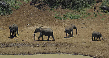
The Lewa Wildlife Conservancy and Ngare Ndare Forest Reserve component of the property incorporates lower lying, scenic foothills and arid habitats of high biological richness and diversity. The component lies at the ecological transition zone between the Afro Tropical Mountain ecosystem and the semi-arid East African Savannah Grasslands. Lewa Wildlife Conservancy and Ngare Ndare Forest Reserve also lie within the traditional migration route of the African elephant population of the Mount Kenya – Somali/Maasai ecosystem and has always been the traditional dry season feeding area for elephants.
Integrity
The serial property comprises Mount Kenya National Park managed by the Kenya Wildlife Service (KWS) and parts of the Mount Kenya Forest Reserve managed by the Kenya Forest Service (KFS). Both these protected areas are designed to protect the main natural values and the watershed of the mountain above the 2,000 - 2,500m elevations. To the north the property is connected via a 9.8 km elephant corridor to the Lewa Wildlife Conservancy and Ngare Ndare Forest Reserve (LWC-NNFR) which adds lowland drier ecosystems and habitats and a suite of additional species to the property. The corridor is within the buffer zone but critical to maintain ecological connectivity between the two components of the property. Despite a number of threats to the property, wildlife populations, though reduced from the years prior to the first inscription of the property on the World Heritage List, are still considered healthy.
The boundaries of the property on the main area of Mount Kenya are limited to the upper reaches of the mountain above the montane forest zone and most of the forest destruction, illegal grazing, poaching and other human activities which impact the broader ecosystem are occurring outside the property, in the area of forest/national reserve that serves as a ‘buffer zone’. Understanding and mitigating these threats to the broader ecosystem is important because they impact the long-term viability of the property.
Climate change is probably one of the most serious long-term threats to the site. Glaciers are melting fast and appear destined to disappear altogether within a few decades. As the climate warms the vegetation zones can be expected to shift higher up the mountain. For example, the lower parts of the bamboo zone (which occur at the lower limit of the property) will likely gradually be replaced with mixed montane forest. It is essential that the threat of climate change is buffered through enhanced connectivity and ensuring that natural habitats covering the full range of altitude are maintained as a continuum, thus providing ecosystem resilience and allowing for adaptation to the inevitable change. The LWC-NNFR by establishing the corridor and regional linkages via several conservancies to link with Samburu National Park, Shaba National Reserve and Buffalo Springs to the north and beyond to the Matthew’s Range is a significant proactive intervention to mitigate climate change impacts on the biodiversity of this region of East Africa providing mobility for biodiversity to adapt to changing temperature and rainfall regimes.
Protection and management requirements
The property’s legislative framework is generally sound and provides for adequate protection of the site. The most relevant legislation is provided by the Wildlife Act, the Environment Management and Coordination Act (1999), the Water Act (2002), and the Forest Act (2005). The Government of Kenya, through KWS has promoted the formation of wildlife conservancies amongst owners of large tracks of land especially amongst local communities as a long-term strategy to increase range for biodiversity conservation and management in the country. LWC is managed for the conservation of biological diversity and thus has met the national legal requirements for designation as a conservancy. In addition the National Land Policy of the Ministry of Lands supports the establishment of corridors for biodiversity conservation.
Three institutions require close coordination to manage the serial property. These include KWS and KFS as well as the Lewa Wildlife Conservancy managed through a Board of Trustees. KWS and KFS are signatories to the Mount Kenya Ecosystem Management Plan which provides an overarching management planning framework. It is essential that the separate management plans applying to the components of the property are harmonised in terms of management approaches and timeframes.
More sustainable management of various sections of the forest has been supported through the establishment of Community Forestry Associations (CFAs) and the production of operational forest management plans and related agreements signed between KFS and the CFAs.
There is a major problem with crop damage caused by elephant, buffalo and other large mammals moving into fields along the lower boundary of the Mount Kenya National/Forest Reserve. Various attempts have been made to mitigate this human-wildlife conflict problem by fencing and construction of other barriers to stop animals moving out of the reserve. These have had mixed results, nevertheless, as experience has shown elsewhere, effective and well considered fencing is likely to be the best option for mitigating human/wildlife conflict in such a densely populated landscape.
Past threats from commercial tree plantation development and associated cultivation/habitat destruction have been alleviated through long term efforts. Government policy not to convert any more natural forest for plantation development has significantly reduced the threat to the property from plantation development and associated cultivation in the adjacent buffer zone. Nevertheless, the ecological consequences of the failed plantation development activities of past decades remain. Areas which were cleared for plantations, but never planted, have been colonised by grasses and are being maintained as open grazing lands, rather than being allowed to revert to natural forest.
Threats from illegal logging, grazing, poaching and tourism are being managed and appear to be stable notwithstanding on-going issues. Continued monitoring and effective management of these issues will be needed. Fire is a major threat, especially in the high altitude moorlands of the World Heritage property. The threat is exacerbated by the increasing number of people living around the periphery of the forest, and making daily incursions up the mountain to graze livestock and collect non-timber forest products. Stakeholders have jointly developed a Mount Kenya Hotspot Strategic Fire Plan to guide future fire preparedness within the ecosystem.
The maintenance of the 9.8km elephant corridor connecting Mount Kenya to the lowland areas of the LWC-NNFR is critical to provide a contiguous link between the two components of the property, thereby supporting wildlife movements and buffering against climate change impacts. It is also critical to explore other opportunities to create connectivity within the larger ecosystem complex to enhance the ecological viability of the property.
4. Emphasizes the critical importance of maintaining the wildlife and elephant corridor between the Lewa Wildlife Conservancy - Ngare Ndare Forest Reserve and the Mountt Kenya National Park/Natural Forest World Heritage Site as vital to conservation connectivity and the viability of the property’s Outstanding Universal Value;
5. Commends the State Party of Kenya for enhancing the ecological connectivity and habitat diversity of the Mount Kenya National Park/Natural Forest through this serial extension;
6. Encourages the State Party to consider further extension of the boundary of Mount Kenya National Park/Natural Forest World Heritage Site, so as to include the lower natural forests and to achieve broader ecological connectivity and coherence.
Draft Decision: 37 COM 7B.3
The World Heritage Committee,
1. Having examined Document WHC-13/37.COM/7B,
2. Recalling Decision 35 COM 7B.2, adopted at its 35th session (UNESCO, 2011),
3. Commends the State Party for the effective collaboration between the Wildlife and Forest Services and their efforts to increase stakeholder involvement in the site’s management, particularly through agreements with Community Forest Associations;
4. Notes with concern the significant forest fire that affected the property in March 2012 and reportedly affected 10% of the Mount Kenya National Park; and requests the State Party to submit to the World Heritage Centre a report on the impacts of this fire on the Outstanding Universal Value of the property and the actions taken for ecological restoration of the affected areas;
5. Notes with satisfaction the initiatives taken to improve fire risk preparedness, and to participate in the design of a climate change adaptation methodology for World Heritage Site managers but regrets that the State Party provided only limited information on the implementation of the recommendations of the 2008 reactive monitoring mission or the concerns raised by the Committee at its 35th session;
6. Requests the State Party to urgently implement the remaining recommendations of the 2008 reactive monitoring mission, in particular the replacement of physical boundary signs and the establishment of additional wildlife corridors;
7. Also requests the State Party to submit to the World Heritage Centre, by 1 February 2014, an updated report on the state of conservation of the property and in particular on the impacts of the 2012 forest fire as well as on the progress made in implementing the outstanding recommendations of the 2008 reactive monitoring mission.
 Kenya
Kenya
* :
The threats indicated are listed in alphabetical order; their order does not constitute a classification according to the importance of their impact on the property.
Furthermore, they are presented irrespective of the type of threat faced by the property, i.e. with specific and proven imminent danger (“ascertained danger”) or with threats which could have deleterious effects on the property’s Outstanding Universal Value (“potential danger”).
** : All mission reports are not always available electronically.

