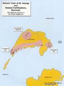
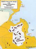
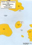
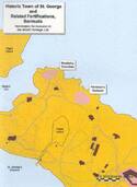
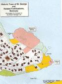
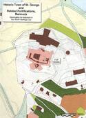
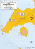
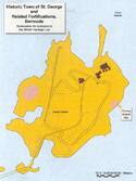
Historic Town of St George and Related Fortifications, Bermuda
Multiple Locations (24)
| ID | Name & Location | State Party | Coordinates | Property | Buffer Zone |
|---|---|---|---|---|---|
| 983-001 | Historic Town of St George | United Kingdom of Great Britain and Northern Ireland |
N32 22 54.48 W64 40 36.13 |
195.7 ha | 746 ha |
| 983-002 | Devonshire Redoubt | United Kingdom of Great Britain and Northern Ireland |
N32 20 27.35 W64 40 20.42 |
0.214 ha | — |
| 983-003 | Landward Fort | United Kingdom of Great Britain and Northern Ireland |
N32 20 24.29 W64 40 23.34 |
0.4738 ha | — |
| 983-004 | Seaward Fort (King's Castle) | United Kingdom of Great Britain and Northern Ireland |
N32 20 27.75 W64 40 10.65 |
0.105 ha | — |
| 983-005 | Southampton Fort | United Kingdom of Great Britain and Northern Ireland |
N32 20 30.16 W64 40 3 |
0.1513 ha | — |
| 983-006 | St. David's Battery | United Kingdom of Great Britain and Northern Ireland |
N32 22 4.85 W64 38 55.35 |
0.4869 ha | — |
| 983-007 | Fort Popple | United Kingdom of Great Britain and Northern Ireland |
N32 22 17.18 W64 38 55.29 |
0.0729 ha | — |
| 983-008 | Paget Fort | United Kingdom of Great Britain and Northern Ireland |
N32 22 24.74 W64 39 25.81 |
0.2223 ha | — |
| 983-009 | Smith's Fort | United Kingdom of Great Britain and Northern Ireland |
N32 22 19.31 W64 39 27.32 |
0.0476 ha | — |
| 983-010 | Fort Cunningham | United Kingdom of Great Britain and Northern Ireland |
N32 22 30.15 W64 39 30.2 |
0.3147 ha | — |
| 983-011 | Musketry Trenches | United Kingdom of Great Britain and Northern Ireland |
N32 22 34.70 W64 39 39.60 |
0.0777 ha | — |
| 983-012 | Peniston's Redoubt | United Kingdom of Great Britain and Northern Ireland |
N32 22 31.70 W64 39 34.00 |
0.1153 ha | — |
| 983-013 | Alexandra Battery | United Kingdom of Great Britain and Northern Ireland |
N32 22 50.28 W64 39 52.52 |
1.245 ha | — |
| 983-014 | Gate's Fort (Town Cut Battery) | United Kingdom of Great Britain and Northern Ireland |
N32 22 45.68 W64 39 45.34 |
0.0792 ha | — |
| 983-015 | Fort Albert | United Kingdom of Great Britain and Northern Ireland |
N32 23 13.28 W64 40 21.7 |
0.3817 ha | — |
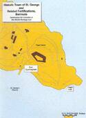
| 983-016 | Fort St. Catherine | United Kingdom of Great Britain and Northern Ireland |
N32 23 27.03 W64 40 26.72 |
0.4303 ha | — |
| 983-017 | Fort Victoria | United Kingdom of Great Britain and Northern Ireland |
N32 23 13.86 W64 40 31.32 |
0.7448 ha | — |
| 983-018 | Western Redoubt (Fort William) | United Kingdom of Great Britain and Northern Ireland |
N32 23 4.03 W64 40 33 |
0.2162 ha | — |
| 983-019 | Fort George | United Kingdom of Great Britain and Northern Ireland |
N32 22 50.28 W64 40 56.62 |
0.3826 ha | — |
| 983-020 | Burnt Point Fort | United Kingdom of Great Britain and Northern Ireland |
N32 21 44.08 W64 42 57.18 |
0.0624 ha | — |
| 983-021 | Martello Tower | United Kingdom of Great Britain and Northern Ireland |
N32 21 47.19 W64 42 53.44 |
0.0833 ha | — |
| 983-022 | Ferry Reach Magazine | United Kingdom of Great Britain and Northern Ireland |
N32 21 48.65 W64 42 51.96 |
0.0811 ha | — |
| 983-023 | Ferry Island Fort | United Kingdom of Great Britain and Northern Ireland |
N32 21 43.82 W64 42 49.61 |
0.1866 ha | — |
| 983-024 | Coney Island Kiln | United Kingdom of Great Britain and Northern Ireland |
N32 21 28.50 W64 42 53.10 |
0.007 ha | — |
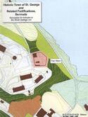
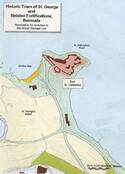
Maps


-125--20100827174728.jpg)

Disclaimer
The Nomination files produced by the States Parties are published by the World Heritage Centre at its website and/or in working documents in order to ensure transparency, access to information and to facilitate the preparations of comparative analysis by other nominating States Parties.
The sole responsibility for the content of each Nomination file lies with the State Party concerned. The publication of the Nomination file does not imply the expression of any opinion whatsoever of the World Heritage Committee or of the Secretariat of UNESCO concerning the history or legal status of any country, territory, city or area or of its boundaries.