New Inscribed Properties
Cultural properties
Aasivissuit – Nipisat. Inuit Hunting Ground between Ice and Sea
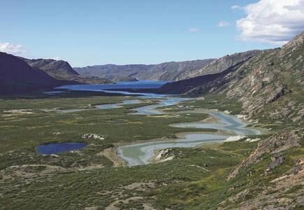
Located inside the Arctic Circle in the central part of West Greenland, the property contains the remains of 4,200 years of human history. It is a cultural landscape which bears witness to its creators’ hunting of land and sea animals, seasonal migrations and a rich and well-preserved tangible and intangible cultural heritage linked to climate, navigation and medicine. The features of the property include large winter houses and evidence of caribou hunting, as well as archaeological sites from Paleo-Inuit and Inuit cultures. The cultural landscape includes seven key localities, from Nipisat in the west to Aasivissuit, near the ice cap in the east. It bears testimony to the resilience of the human cultures of the region and their traditions of seasonal migration.
Al-Ahsa Oasis, an Evolving Cultural Landscape
In the eastern Arabian Peninsula, the Al-Ahsa Oasis is a serial property comprising gardens, canals, springs, wells and a drainage lake, as well as historical buildings, urban fabric and archaeological sites. They represent traces of continued human settlement in the Gulf region from the Neolithic to the present, as can be seen from remaining historic fortresses, mosques, wells, canals and other water management systems. With its 2.5 million date palms, it is the largest oasis in the world. Al-Ahsa is also a unique geocultural landscape and an exceptional example of human interaction with the environment.
Ancient City of Qalhat
The property, which is located on the east coast of the Sultanate of Oman, includes the ancient city of Qalhat, surrounded by inner and outer walls, as well as areas beyond the ramparts where necropolises are located. The city developed as a major port on the east coast of Arabia between the 11th and 15th centuries CE, during the reign of the Hormuz princes. The Ancient City bears unique archaeological testimony to the trade links between the east coast of Arabia, East Africa, India, China and South-East Asia.
Archaeological Border complex of Hedeby and the Danevirke
The archaeological site of Hedeby consists of the remains of an emporium – or trading town – containing traces of roads, buildings, cemeteries and a harbour dating back to the 1st and early 2nd millennia CE. It is enclosed by part of the Danevirke, a line of fortification crossing the Schleswig isthmus, which separates the Jutland Peninsula from the rest of the European mainland. Because of its unique situation between the Frankish Empire in the South and the Danish Kingdom in the North, Hedeby became a trading hub between continental Europe and Scandinavia and between the North Sea and the Baltic Sea. Because of its rich and well preserved archaeological material, it has become a key site for the interpretation of economic, social and historical developments in Europe during the Viking age.
Caliphate City of Medina Azahara
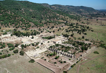
The Caliphate city of Medina Azahara is an archaeological site of a city built in the mid-10th century CE by the Umayyad dynasty as the seat of the Caliphate of Cordoba. After prospering for several years, it was laid to waste during the civil war that put an end to the Caliphate in 1009-1010. The remains of the city were forgotten for almost 1,000 years until their rediscovery in the early 20th century. This complete urban ensemble features infrastructure such as roads, bridges, water systems, buildings, decorative elements and everyday objects. It provides in-depth knowledge of the now vanished Western Islamic civilization of Al-Andalus, at the height of its splendour.
Göbekli Tepe
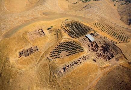
Located in the Germuş mountains of south-eastern Anatolia, this property presents monumental round-oval and rectangular megalithic structures erected by hunter-gatherers in the Pre-Pottery Neolithic age between 9,600 and 8,200 BCE. These monuments were probably used in connection with rituals, most likely of a funerary nature. Distinctive T-shaped pillars are carved with images of wild animals, providing insight into the way of life and beliefs of people living in Upper Mesopotamia about 11,500 years ago.
Hidden Christian Sites in the Nagasaki Region
Located in the north-western part of Kyushu island, this serial property consists of ten villages, remains of the Hara Castle and a cathedral, dating from the 17th to the 19th centuries. They reflect the era of prohibition of the Christian faith, as well as the revitalization of Christian communities after the official lifting of prohibition in 1873. These sites bear unique testimony to a cultural tradition nurtured by hidden Christians in the Nagasaki region who secretly transmitted their faith during the period of prohibition from the 17th to the 19th century.
Naumburg Cathedral
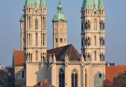
Located in the eastern part of the Thuringian Basin, the Cathedral of Naumburg, whose construction began in 1028, is an outstanding testimony to medieval art and architecture. Its Romanesque structure, flanked by two Gothic choirs, demonstrates the stylistic transition from late Romanesque to early Gothic. The west choir, dating to the first half of the 13th century, reflects changes in religious practice and the appearance of science and nature in the figurative arts. The choir and life-size sculptures of the founders of the Cathedral are masterpieces of the workshop known as the ‘Naumburg Master’.
Sansa, Buddhist Mountain Monasteries in Korea
The Sansa are Buddhist mountain monasteries located throughout the southern provinces of the Korean Peninsula. The spatial arrangement of the seven temples that comprise the property, established from the 7th to 9th centuries, present common characteristics that are specific to Korea – the ‘madang’ (open courtyard) flanked by four buildings (Buddha Hall, pavilion, lecture hall and dormitory). They contain a large number of individually remarkable structures, objects, documents and shrines. These mountain monasteries are sacred places, which have survived as living centres of faith and daily religious practice to the present.
Sassanid Archaeological Landscape of Fars Region
The eight archaeological sites situated in three geographical areas in the southeast of Fars Province: Firuzabad, Bishapur and Sarvestan. The fortified structures, palaces and city plans date back to the earliest and latest times of the Sassanian Empire, which stretched across the region from 224 to 658 CE. Among these sites is the capital built by the founder of the dynasty, Ardashir Papakan, as well as a city and architectural structures of his successor, Shapur I. The archaeological landscape reflects the optimized utilization of natural topography and bears witness to the influence of Achaemenid and Parthian cultural traditions and of Roman art, which had a significant impact on the architecture of the Islamic era.
Thimlich Ohinga Archaeological Site
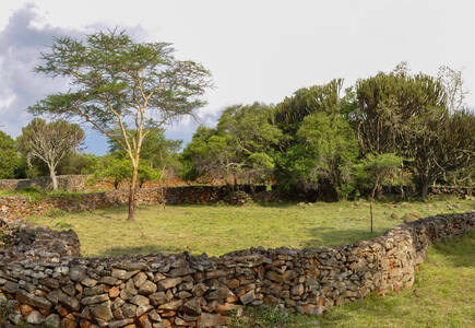
Situated north-west of the town of Migori, in the Lake Victoria region, this dry-stone walled settlement was probably built in the 16th century CE. The Ohinga (i.e. settlement) seems to have served as a fort for communities and livestock, but also defined social entities and relationships linked to lineage. Thimlich Ohinga is the largest and best preserved of these traditional enclosures. It is an exceptional example of the tradition of massive dry-stone walled enclosures, typical of the first pastoral communities in the Lake Victoria Basin, which persisted from the 16th to the mid-20th century.
Victorian Gothic and Art Deco Ensembles of Mumbai
Having become a global trading centre, the city of Mumbai implemented an ambitious urban planning project in the second half of the 19th century. It led to the construction of ensembles of public buildings bordering the Oval Maidan open space, first in the Victorian Neo-Gothic style and then, in the early 20th century, in the Art Deco idiom. The Victorian ensemble includes Indian elements suited to the climate, including balconies and verandas. The Art Deco edifices, with their cinemas and residential buildings, blend Indian design with Art Deco imagery, creating a unique style that has been described as Indo-Deco. These two ensembles bear testimony to the phases of modernization that Mumbai has undergone in the course of the 19th and 20th centuries.
New Inscribed Properties
Natural properties
Barberton Makhonjwa Mountains
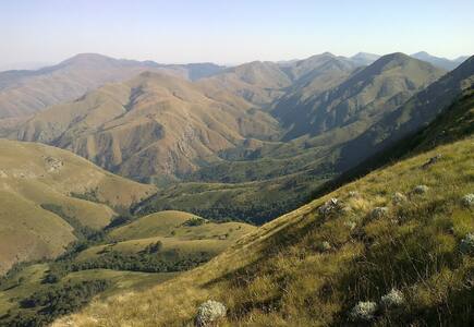
Situated in north-eastern South Africa, the Barberton Makhonjwa Mountains comprises 40% of the Barberton Greenstone Belt, one of the world’s oldest geological structures. The property represents the best-preserved succession of volcanic and sedimentary rock dating back 3.6 to 3.25 billion years and forms a diverse repository of information on surface conditions, meteorite impacts, volcanism, continent-building processes and the environment of early life.
Chaîne des Puys - Limagne fault tectonic arena
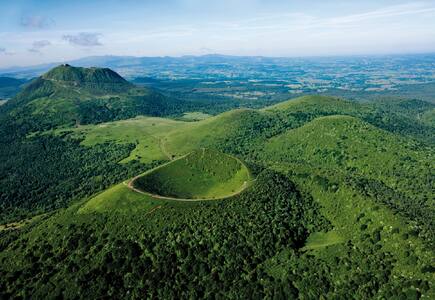
Situated in the centre of France, the property comprises the long Limagne fault, the alignments of the Chaîne des Puys volcanoes and the inverted relief of the Montagne de la Serre. It is an emblematic segment of the West European Rift, created in the aftermath of the formation of the Alps, 35 million years ago. The geological features of the property demonstrate how the continental crust cracks, then collapses, allowing deep magma to rise and cause uplifting at the surface. The property is an exceptional illustration of continental break-up – or rifting – which is one of the five major stages of plate tectonics.
Fanjingshan
Located within the Wuling mountain range in Guizhou Province (south-west China), Fanjingshan ranges in altitude between 500 metres and 2,570 metres above sea level, favouring highly diverse types of vegetation and relief. It is an island of metamorphic rock in a sea of karst, home to many plant and animal species that originated in the Tertiary period, between 65 million and 2 million years ago. The property’s isolation has led to a high degree of biodiversity with endemic species, such as the Fanjingshan Fir (Abies fanjingshanensis) and the Guizhou Snub-nosed Monkey (Rhinopithecus brelichi), and endangered species, such as the Chinese Giant Salamander (Andrias davidianus), the Forest Musk Deer (Moschus berezovskii) and Reeve’s Pheasant (Syrmaticus reevesii). Fanjingshan has the largest and most contiguous primeval beech forest in the subtropical region.
New Inscribed Properties
Mixed properties
Chiribiquete National Park – “The Maloca of the Jaguar”
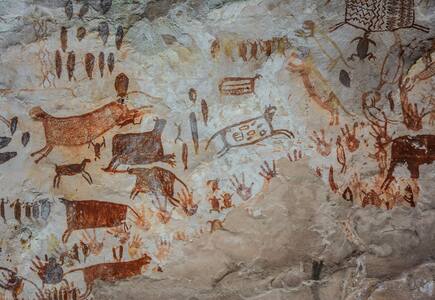
Chiribiquete National Park, the largest protected area in Colombia, is the confluence point of four biogeographical provinces: Amazon, Andes, Orinoco and Guyana. As such, the National Park guarantees the connectivity and preservation of the biodiversity of these provinces, constituting itself as an interaction scenario in which flora and fauna diversity and endemism have flourished. One of the defining features of Chiribiquete is the presence of tepees (table-top mountains), sheer-sided sandstone plateaux that outstand in the forest and result in dramatic scenery that is reinforced by its remoteness, inaccessibility and exceptional conservation. Over 75,000 figures have been made by indigenous people on the walls of the 60 rock shelters from 20,000 BCE, and are still made nowadays by the uncontacted peoples protected by the National Park. These paintings depict hunting scenes, battles, dances and ceremonies, as well as fauna and flora species, with a particular the worship of the jaguar, a symbol of power and fertility. The indigenous communities, which are not directly present on the site, consider Chiribiquete as a sacred place that cannot be visited and that should be preserved unaltered.
Pimachiowin Aki
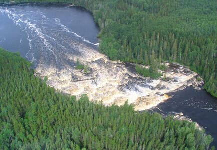
Pimachiowin Aki ('The Land That Gives Life') is a landscape of rivers, lakes, wetlands, and boreal forest. It forms part of the ancestral home of the Anishinaabeg, an indigenous people living from fishing, hunting and gathering. The site encompasses the traditional lands of four Anishinaabeg communities (Bloodvein River, Little Grand Rapids, Pauingassi and Poplar River). It is an exceptional example of the cultural tradition of Ji-ganawendamang Gidakiiminaan ('keeping the land'), which consists of honouring the gifts of the Creator, respecting all forms of life, and maintaining harmonious relations with others. A complex network of livelihood sites, habitation sites, travel routes and ceremonial sites, often linked by waterways, provides testimony to this ancient and continuing tradition.
Tehuacán-Cuicatlán Valley: originary habitat of Mesoamerica
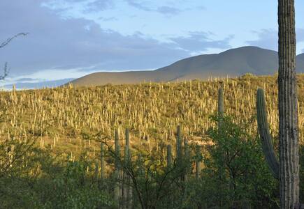
Tehuacán-Cuicatlán Valley, part of the Mesoamerican region, is the arid or semi-arid zone with the richest biodiversity in all of North America. Consisting of three components, Zapotitlán-Cuicatlán, San Juan Raya and Purrón, it is one of the main centres of diversification for the cacti family, which is critically endangered worldwide. The valley harbours the densest forests of columnar cacti in the world, shaping a unique landscape that also includes agaves, yuccas and oaks. Archaeological remains demonstrate technological developments and the early domestication of crops. The valley presents an exceptional water management system of canals, wells, aqueducts and dams, the oldest in the continent, which has allowed for the emergence of agricultural settlements.
Significant modifications to the boundaries
Natural properties
Central Sikhote-Alin
The Sikhote-Alin mountain range contains one of the richest and most unusual temperate forests of the world. In this mixed zone between taiga and subtropics, southern species such as the tiger and Himalayan bear cohabit with northern species such as the brown bear and lynx. After its extension in 2018, the property includes the Bikin River Valley, located about 100 km to the north of the existing site. It encompasses the South-Okhotsk dark coniferous forests and the East-Asian coniferous broadleaf forests. The fauna includes species of the taiga alongside southern Manchurian species. It includes notable mammals such as the Amur Tiger, Siberian Musk Deer, Wolverine and Sable.
Views
World Heritage List statistics
