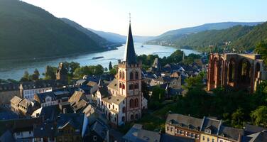
Upper Middle Rhine Valley
Factors affecting the property in 2010*
- Effects arising from use of transportation infrastructure
- Ground transport infrastructure
- Input of excess energy
Factors* affecting the property identified in previous reports
a) Noise pollution and traffic increase;
b) Potential impacts by Rhine crossing project.
International Assistance: requests for the property until 2010
Total amount approved : 0 USD
Missions to the property until 2010**
February 2008: Joint World Heritage Centre / ICOMOS advisory mission
Conservation issues presented to the World Heritage Committee in 2010
The State Party submitted on 19 January 2010 an English version of the Environmental Impact Assessment (EIA), and on 8 February 2010 a report that included a draft Statement of Outstanding Universal Value, a Visual Impact Assessment undertaken by the Technical University of Aachen and a traffic evaluation of the bridge, ferry and tunnel options also undertaken by the University of Aachen.
a) Environmental Impact Assessment (EIA)
For the 33rd session of the World Heritage Committee only the summary version of the EIA had been provided by the State Party. At the request of the Committee the full version has submitted and this has been assessed by ICOMOS.
Four different options are investigated in the EIA: a high bridge option and a low bridge option between St. Goar and St. Goarshausen, a bridge in the vicinity of Fellen/Wellmich (for which a competition has been held) as well as a tunnel option. The current situation, namely the ferry option between St. Goar and St. Goarshausen, is not included in the analysis.
The World Heritage status is covered in a one page discussion, quoting the criteria and the justification. A detailed analysis of all the attributes that contribute to the property’s Outstanding Universal Value are not included nor the interplay between historic, natural and structural characteristics and associative features of the cultural landscape. Nonetheless the EIA’s starting point is that “area of investigation … to a large extent can be described as a prime example of a significant historical cultural landscape” that can be evaluated as being most important (pp. 93 -95).
The discussion concerns the “visual influence of the cultural historical context of fortified castles and the Rhine views” (ibid.). In conclusion it states that the potential danger of the two bridge options near St. Goar and St. Goarshausen can be considered “very high” and the tunnel option can be referred to as “moderate” (pp. 176f.). Regarding the bridge location at Fellen/Wellmich, it was considered that selected points of impairment of the landscape interfere with the cultural and historical context, with respect to the landscape of Burg Maus (Fortified Castle Maus), the settlement of Wellmich with its mediaeval church and its relationship with the Rhine are also endangered (p. 177). With respect to a bridge near Fellen/Wellmich the environmental impact study states that this location, in comparison to the others, “offers more favourable conditions in order to realize a bridge structure.” (p. 167).
Moreover, it is stated that a bridge at this particular location coming from the south would create “a considerable break with the following natural landscape of the Rhine Valley section” and “the impressive cultural landscape located near Wellmich could be considerably impaired” (p. 167). This special character of landscape is described as also typical for the development of settlements along the exits of the side valleys of the Rhine Valley. “Wellmich stretches from alongside the Rhine Valley slope as well as into the Wellmich Brook Valley. The town developed with houses built close together around the church in the proportions of the valley exists and are integrated in a cultural and historical context into the upper Middle Rhine Valley architecturally by proportion, selection of colour and material. The church built using natural stone forms a charming ensemble with the castle positioned at the top” (p. 166).
The conclusions of the EIA are that “the tunnel option … represents the alternative of a permanent Rhine crossing that influences the overall appearance of the Upper Middle Rhine Valley least.” (pp. 182f.) The bridge options in comparison are all associated with visual impairments given the very delicate situation of the valley area” (p. 183). “In general it can be assumed that the already mentioned impairments of the landscape … can appear more or less considerably with any type of structure. On the one hand, this depends on the technical requirements placed on the bridge construction …; on the other hand, the Upper Middle Rhine Valley especially in the section of investigation between Wellmich and the Lorelei is considered a very delicate valley area especially with respect to the risks presented by new technical structures due to the high level importance associated with a clear and undisturbed view”.
b) Traffic evaluation of the bridge, ferry and tunnel options
This evaluation considers one bridge option, Fellen/Wellmich, a tunnel in the central location of St. Goar / St. Goarshausen and three ferries operating simultaneously in different locations. It considers economic and traffic arguments.
It states that existing studies assume that the tunnel would take 7,400 vehicles a day and the bridge 7,000 and of that traffic between 1,500 and 2,000 cars would be ‘new’ traffic.However the study assumes that only 3,500 vehicles a day will use the ferry.
The key drivers for the bridge are seen as economic – in terms of the perceived worsening economic situation in the Rhine Valley. The bridge is seen as a way to improve contacts to the motorway network. The current roads are said to be “inhibited by the fact that an efficient connection to the A3 motorway on the right side of the Rhine is only accessible in a limited fashion due to the relatively great distance…. The responsible authorities in the region hope not only for improved transportation conditions within the “Upper Middle Rhine Valley” from the planned new linking of the sub-areas on the right and left sides of the Rhine in the form of an additional Rhine bridge, but also impulses and symbolic effects that could reduce the currently clearly recognisable negative economic and demographic developments within the area of the World Heritage property”.
The conclusions are that it is possible in principle to improve the ferry connections, but there are limitations in respect of reliability and usability and a ferry connection would generate significantly higher running costs than a bridge. A tunnel solution generates roughly the same level of costs as a ferry connection, and significantly higher costs than a bridge. A bridgerepresents the most economically favourable solution. It best improves availability for all classes of traffic and is the only possible solution that has no restrictions with regard to acceptance and usability. This means that it is best suited to forming the basis for a modern improvement in the structural situation in the Middle Rhine Valley.
c) Visual Impact Assessment
In the Visual Impact Assessment text the justification for the criteria are quoted as defining the Outstanding Universal Value of the property but not the ‘Statement of Significance’ and ‘Brief Description’ as set out in ICOMOS’s evaluation. At the time of inscription, the Committee did not adopt a Statement of Outstanding Universal Value only the justification for the criteria. The State Party’s text suggests that although ICOMOS had mentioned Rhine Romanticism in its text, it had not included cultural associations in it assessment of Outstanding Universal Value. However if the text of the Brief Description and Statement of Significance are considered, (which would now be called the synthesis) then clearly the Outstanding Universal Value does encompass the influence the landscape had on writers, artists and composers.
The impact assessment nevertheless does consider the visual significance of the Rhine Valley landscape and its Romantic associations:
“The visualisations of the planned Rhine bridge show that, due to its location between Hirzenach/Kestert and Fellen/Wellmich, it principally only minorly impairs the existing landscape qualities. The valley section can also continue to be perceived as an integral area from elevated viewpoints. The mostly intact slopes are not visually disrupted.
The “viewing triangle” between Rheinfels Castle (left bank of the Rhine) and the castles Katz or Maus (right bank of the Rhine) is also not influenced by the planned bridge structure. The planned bridge can also not be seen from historically important viewing points such as the Lorelei (right bank of the Rhine) and the “Werlauer Pilz” (left bank of the Rhine).
“Classic” views from the banks, like from Fellen in the direction of Wellmich with the Maus Castle, today have no prominent significance either as tourist attractions, but are also principally not impaired. When one approaches the bridge upstream on a ship, the views of Rhine ships in the direction of Wellmich and the Maus Castle are intermittently impaired. However, after passing beneath the bridge, there is still a comparatively long view corridor towards Wellmich”.
The conclusion is thus drawn that ‘The planned bridge between Wellmich and Fellen is located outside areas particularly sensitive in terms of cultural history or cultural landscape. In comparison with the other sections of the “Upper Middle Rhine Valley” this area is of subordinate significance with respect to the values and characteristics of the World Heritage property „Upper Middle Rhine Valley“.
d) Management Plan
The State Party reports states that the development of a locally and regionally promoted “master plan” for the property in the medium term is seen as absolutely essential, because the planned Rhine bridge represents only one building block of many in this context of necessary measures.
The World Heritage Centre and the Advisory Bodies consider that the EIA clearly demonstrates the overall sensitivity of the Rhine Valley landscape and the adverse impact that the proposed bridge could have on the cultural landscape. The traffic assessment demonstrates that a bridge would be the easiest solution in terms of use and thus would probably generate most traffic. The Visual Impact Assessment suggests that the area of the Rhine Valley north of St. Goar and St. Goarhausen is in some way of lesser importance to the overall Outstanding Universal Value of the property than the area immediately to its south but does not set out a convincing argument as to how it might still contribute to Outstanding Universal Value. The landscape of the Rhine Valley is one of contrasts and surprises as the traveler moves down the river. The landscape near Wellmich clearly is not one of the dramatic views but is the approach to the dramatic views and as such a very necessary part of the overall harmonious landscape as is demonstrated by the fact that the whole property is designated as being of outstanding natural beauty.
The text also suggests that as the property was inscribed as a cultural landscape (evolving cultural landscape), then the development of a bridge can be seen to be in accordance with its categorisation. However, although evolving cultural landscapes will develop they must evolve in a way that protects the attributes of Outstanding Universal Value. Thus the impact assessment needs to consider the impact of the proposed bridge on the attributes of Outstanding Universal Value.
The State Party report also stresses that it is essential for any consideration of bridges to be integrated into an overall management plan for the property as it said that the planned Rhine bridge represents only one building block of many in this context of necessary measures. The World Heritage Centre the Advisory Bodies consider that this demonstrates the need for a greater understanding of where the development of the property might be heading, what these necessary measures are, and how they all might contribute to the sustainable development of the landscape. On the one hand, there are ambitious plans to restore terraced vineyards that contributed so strongly to the landscape patterns until the last few decades, while on the other hand, the proposed bridge would generate up to 2,000 extra cars a day, and add significantly to pollution and noise. In this context the World Heritage Centre and the Advisory Bodies recall that concern was expressed to the World Heritage Committee at its 33rd session at the overall noise levels emanating from both road and rail traffic.
There is an urgent need to set out a vision for this property that fully articulates how the attributes of the property might be developed in a sustainable way.
Summary of the interventions
Decisions adopted by the Committee in 2010
34 COM 7B.87
Upper Middle Rhine Valley (Germany) (C 1066)
The World Heritage Committee,
1. Having examined Document WHC-10/34.COM/7B,
2. Recalling Decision 33 COM 7B.104, adopted at its 33rd session (Seville, 2009),
3. Acknowledges the receipt of the full Environmental Impact Assessment, the new Traffic Evaluation of bridge, tunnel and ferries and the Visual Impact Assessment supplied by the State Party;
4. Notes that:
a) The Environmental Impact Assessment clearly demonstrates the overall sensitivity of the Rhine Valley landscape and the adverse impact that the proposed bridge would have on the cultural landscape,
b) The traffic evaluation demonstrates that the bridge represents the most economically favorable solution, and
c) The Visual Impact Study demonstrates that, if the valley north of St. Goar and St. Goarhausen is in some way of lesser importance to the overall Outstanding Universal Value of the property than the area immediately to its south, then the bridge could be considered acceptable in visual terms;
5. Also notes that the State Party considers that it is essential that a "master plan" for the property is developed as the planned Rhine bridge represents only one building block of many in this context of necessary measures;
6. Also acknowledges the intense cooperation undertaken to preserve the Outstanding Universal Value and the detailed information provided so far, and requests to continue the close dialogue in the course of the now starting national planning process.
7. Considers that it is essential that any development of the valley not only sustains Outstanding Universal Value but also contributes to the overall sustainable development of the property, and that a Master Plan should be developed setting out a vision for the property and how it will be realized over the next few decades and thus setting out the further measures that might be associated with a new bridge;
8. Further acknowledges receipt of the draft Statement of Outstanding Universal Value that will be reviewed by the Advisory Bodies and presented to the World Heritage Committee at its 35th session;
9. Also requests the State Party to submit to the World Heritage Centre by 1 February 2011 a report on the progress of the Master Plan, for examination by the World Heritage Committee at its 35th session in 2011.
Draft Decision: 34 COM 7B.87
The World Heritage Committee,
1. Having examined Document WHC-10/34.COM/7B,
2. Recalling Decision 33 COM 7B.104, adopted at its 33rd session (Seville, 2009),
3. Acknowledges the receipt of the full Environmental Impact Assessment, the new Traffic Evaluation of bridge, tunnel and ferries and the Visual Impact Assessment supplied by the State Party;
4. Notes that
a) the Environmental Impact Assessment clearly demonstrates the overall sensitivity of the Rhine Valley landscape and the adverse impact that the proposed bridge would have on the cultural landscape,
b) the traffic evaluation demonstrates that the bridge represents the most economically favourable solution, and
c) the Visual Impact Study demonstrates that, if the valley north of St. Goar and St. Goarhausen is in some way of lesser importance to the overall Outstanding Universal Value of the property than the area immediately to its south, then the bridge could be considered acceptable in visual terms;
5. Also notes that the State Party considers that it is essential that a “master plan” for the property is developed as ‘the planned Rhine bridge represents only one building block of many in this context of necessary measures’;
6. Considers that it is essential that any development of the valley not only sustains Outstanding Universal Valuebut also contributes to the overall sustainable development of the property, and that a Master Plan should be developed setting out a vision for the property and how it will be realized over the next few decades and thus setting out the further measures that might be associated with a new bridge;
7. Acknowledges receipt of the draft Statement of Outstanding Universal Value that will be reviewed by ICOMOS and presented to the World Heritage Committee at its 35th session;
8. Further requests the State Party to submit to the World Heritage Centre by 1 February 2011 a report on the progress of the Master Plan, for examination by the World Heritage Committee at its 35th session in 2011.
 Germany
Exports
* :
The threats indicated are listed in alphabetical order; their order does not constitute a classification according to the importance of their impact on the property.
Furthermore, they are presented irrespective of the type of threat faced by the property, i.e. with specific and proven imminent danger (“ascertained danger”) or with threats which could have deleterious effects on the property’s Outstanding Universal Value (“potential danger”).
** : All mission reports are not always available electronically.

