Historic Centre of Santa Cruz de Mompox
Historic Centre of Santa Cruz de Mompox
Founded in 1540 on the banks of the River Magdalena, Mompox played a key role in the Spanish colonization of northern South America. From the 16th to the 19th century the city developed parallel to the river, with the main street acting as a dyke. The historic centre has preserved the harmony and unity of the urban landscape. Most of the buildings are still used for their original purposes, providing an exceptional picture of what a Spanish colonial city was like.
Description is available under license CC-BY-SA IGO 3.0
Centre historique de Santa Cruz de Mompox
Fondée en 1540 sur les rives de la Magdalena, Mompox joua un rôle clé dans l'emprise espagnole sur le nord de l'Amérique du Sud. Du XVIe au XIXe siècle, la ville se développa parallèlement au fleuve, la première rue servant de digue. Le centre historique a préservé l'harmonie et l'intégrité de son paysage urbain. La majorité des bâtiments conservent aujourd'hui leur fonction d'origine, offrant ainsi l'image exceptionnelle de ce que fut une ville coloniale espagnole.
Description is available under license CC-BY-SA IGO 3.0
وسط سانتا كروز التاريخي في موبوكس
تأسست مدينة موبوكس عام 1540 على ضفاف نهر ماجدلينا وقد أدّت دوراً محورياً في سيطرة اسبانيا على شمال أمريكا الجنوبيّة. منذ القرن السادس وحتّى التاسع، نمت المدينة بمحاذاة النهر واستحال الشارع الأوّل سدّاً. حافظ الوسط التاريخي على انسجام منظره الحضري وتكامله. وتحافظ اليوم غالبيّة المباني على وظيفتها الأساسيّة فتُشكّل الصورة الاستثنائيّة على ما كان ماضياً مدينة مستعمرة اسبانيّة.
source: UNESCO/CPE
Description is available under license CC-BY-SA IGO 3.0
蒙波斯的圣克鲁斯历史中心
蒙波斯(Mompox)于1540年建立于马格达莱纳河(the River Magdalena)河畔,在西班牙殖民统治南美洲北部时发挥了重要作用。从16至19世纪,这个城市沿着河流两岸逐渐发展扩大,主要街道都担当着河堤的作用。历史中心保持了城市景观的和谐与统一。现在大部分建筑物,仍保留原来的使用目的,真实地反映了西班牙统治时期的殖民地城市画面。
source: UNESCO/CPE
Description is available under license CC-BY-SA IGO 3.0
Исторический центр города Санта-Крус-де-Момпокс
Момпокс, основанный в 1540 г. на берегах реки Магдалена, играл важную роль в испанской колонизации севера Южной Америки. С XVI по XIX вв. город развивался вдоль реки, его главная улица играла роль дамбы. Исторический центр сохранил гармонию и единство городского ландшафта. Большинство зданий все еще используется по своему первоначальному назначению, давая яркое представление о том, как выглядел испанский колониальный город.v
source: UNESCO/CPE
Description is available under license CC-BY-SA IGO 3.0
Centro histórico de Santa Cruz de Mompox
Fundada en 1540, a orillas del río Magdalena, Mompox desempeñó un importante papel en el establecimiento de la dominación española en el norte de Sudamérica. Desde el siglo XVI hasta el XIX, la ciudad fue creciendo paralelamente al río y su calle principal servía de dique de contención del río. En su centro histórico se ha preservado la armonía e integridad del paisaje urbano. La mayoría de los edificios siguen cumpliendo todavía su función primigenia, ofreciendo así una imagen excepcional de lo que fue una ciudad colonial española.
source: UNESCO/CPE
Description is available under license CC-BY-SA IGO 3.0
サンタ・クルーズ・デ・モンポスの歴史地区
コロンビア北部の都市。南アメリカ北部の重要な拠点として、スペイン人が1540年に建設。16~18世紀にはマグダレナ川の両岸に発展した。歴史地には建設当時の都市景観の調和や統一感を保ち、スペイン植民地時代の姿を今に伝えている。source: NFUAJ
Historisch centrum van Santa Cruz de Mompox
De stad Mompox werd in 1540 gesticht aan de oevers van de rivier de Magdalena. De oude stad heeft een belangrijke rol gespeeld in de Spaanse kolonisatie van het noorden van Zuid-Amerika. Van de 16e tot de 19e eeuw ontwikkelde de stad zich parallel aan de rivier, waarbij de hoofdstraat fungeerde als een dijk. Het historisch centrum heeft de harmonie en eenheid van het stedelijk landschap behouden. De stadsgebouwen schetsen een goed beeld van hoe een Spaanse koloniale stad er uitzag en de meeste gebouwen worden nog steeds gebruikt voor hun oorspronkelijke doeleinden.
Source: unesco.nl

Outstanding Universal Value
Brief Synthesis
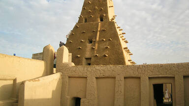
Santa Cruz de Mompox, located in the swampy inland tropics of northern Colombia’s Bolívar Department, was founded about 1539 on the Magdalena River, the country’s principal waterway. Mompox was of great logistical and commercial importance, as substantial traffic between the port of Cartagena and the interior travelled along the river. It consequently played a key role in the Spanish colonization of northern South America, forming an integral part of the processes of colonial penetration and dominion during the Spanish conquest and of the growth of communications and commerce during the 17th to early 19th centuries. The city developed parallel to the river, its sinuous main street growing freely and longitudinally along the river bank, on which barricade walls (albarradas) were built to protect the city during periods of flooding. Instead of the central plaza typical of most Spanish settlements, Mompox has three plazas lined up along the river, each with its own church and each corresponding to a former Indian settlement. Most of the buildings in its 458-ha historic centre are in a remarkable state of conservation and still used for their original purposes, thus preserving an exceptional illustration of a Spanish riverine settlement. Founded in 1540 on the banks of the River Magdalena, Mompox played a key role in the Spanish colonization of northern South America. From the 16th to the 19th century the city developed parallel to the river, with the main street acting as a dyke. The historic centre has preserved the harmony and unity of the urban landscape. Most of the buildings are still used for their original purposes, providing an exceptional picture of what a Spanish colonial city was like.
The historic centre of Santa Cruz de Mompox’s identity as a Spanish colonial river port defines the unique and singular character of its monumental and domestic architecture. From the 17th century onwards, houses were built on the Calle de La Albarrada with the ground floors given over to small shops. These “house-store” buildings are built in rows of between three and ten units. Significant in their contribution to the townscape are the open hallways across the front facades that share a common roof. The private houses of the 17th to early 19th centuries are laid out around a central or lateral open space, creating linked environments adapted to the climate and reflecting local customs. The earliest type of house for merchants or Crown servants has a central courtyard; there is often a secondary courtyard for services attached to the back of the building. Most of the houses retain important features such as decorated portals and interiors, balconies and galleries. The special circumstances of the development of the city along the river have given it a quality with few parallels in this region. Its economic decline in the 19th century conferred a further dimension on this quality, preserving it and making it the region’s most outstanding surviving example of this type of riverine urban settlement.
Criterion (iv): The Historic Centre of Santa Cruz de Mompox forms an integral part of the processes of colonial penetration and dominion during the Spanish conquest and the growth of communications and commerce during the 17th to early 19th centuries.
Criterion (v): The special circumstances of the development of the town, which grew freely and longitudinally following the sinuous path of a road roughly parallel to the river, have given it a special quality with few parallels in the region of northern South America. The subsequent economic decline and the remarkable state of preservation that resulted confers a further dimension on this quality, making it the region’s most outstanding surviving example of this type of riverine urban settlement.
Integrity
The boundaries of the Historic Centre of Santa Cruz de Mompoxare clearly defined and include all the elements necessary to express its Outstanding Universal Value. The property is of sufficient size to adequately ensure the complete representation of the features and processes that convey the property’s significance, and it does not suffer from adverse effects of development and/or neglect.
Authenticity
By virtue of the fact that Santa Cruz de Mompox lost much of its economic importance in the 19th century, its historic centre has not been subjected to the pressures for redevelopment that have affected other towns of this type in northern South America. The historic centre’s original street pattern has been preserved intact, along with a large proportion of its earlier buildings. Its level of authenticity is therefore high in terms of its setting, forms, materials and construction techniques. Most of the buildings are still being used for their original purposes. The historic centre has therefore retained its original residential function. The historic centre is generally in a good state of preservation; private owners have considerable pride in their properties, which they maintain in good condition without government funding.
The Historic Centre of Santa Cruz de Mompoxis subject to flooding. The barricade wall that protects La Albarrada and the historic centre leaks and is deteriorating; as a result, there is a risk of damage to utility networks, structural problems in masonry and harm to walls as a result of humidity.
Protection and management requirements
Ownership of the Historic Centre of Santa Cruz de Mompox is shared among private individuals, institutions, the Roman Catholic Church (the Diocese of Magangué) and local government authorities. Unusually for Colombia, there is in Mompox a tradition of retaining ownership of private houses within a single family. The historic centre was declared a National Monument under the provisions of Law No. 163 of 1959, which covers the basic principles for the management and protection of the cultural heritage. It has been regulated by a municipal building code since 1970, by means of which all construction work within the historic centre is strictly controlled. There are legal provisions to maintain and protect the urban and architectural heritage while adapting to new conditions and the needs of development. The current urban regulations for the historic centre, which devolve the responsibility for certain aspects of the protection of this historic property to local and regional authorities, were approved by the National Monuments Council in March 1994.
The Colombian Cultural Institute (COLCULTURA), part of the Ministry of Education, is the national agency responsible for the preservation of the historic centre of Santa Cruz de Mompox; it is advised by the National Monuments Council. COLCULTURA's Cultural Heritage Office carries out preservation projects through the Division of Historic Centres and Architectural Heritage and the Technical Secretariat of the National Monuments Council. There is no management plan for the property per se. However, the strict building code of 1994, the urban regulations, the national law for all sites that have cultural interest, plus the supervisory role and technical support by the National Government, exercise effective management of the area. There is control over interventions by private owners within the historic area, and specific functions are assigned to the different entities participating in its protection. This code is the model for all historic towns and town centres in Colombia. There is an effective 183-ha buffer zone prescribed in the planning regulations.
Sustaining the Outstanding Universal Value of the property over time will require preparing for and mitigating the high risk of flooding; and taking actions to improve the social and economical conditions of the community in order to overcome problems related to economic stagnation. Additional key management issues that were raised at the time of inscription include restoring the historic character of the important part of the city between Concepción and San Francisco plazas and along the river bank; continuing efforts to ensure the cleanliness of the river bank; and developing a detailed tourism plan that respects the quality of the visitor experience and promotes benefit-sharing mechanisms for local communities as an incentive to enhance their support for the conservation of the property. Priorities for achieving this include concerted planning and action among all relevant national, regional and local governments and local communities. The long-term sustainability of the property would benefit from the further development of an integrated plan that includes all of these actions, and the provision of adequate and sustained institutional and financial support.
 View photos from OUR PLACE the World Heritage collection