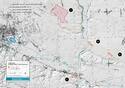
Krzemionki Prehistoric Striped Flint Mining Region
Multiple Locations (4)
| ID | Name & Location | State Party | Coordinates | Property | Buffer Zone |
|---|---|---|---|---|---|
| 1599-001 | Krzemionki Opatowskie Mining Field | Poland |
N50 58 4.7 E21 30 8.3 |
311.3 ha | 1,327.9 ha |
| 1599-002 | Borownia Mining Field | Poland |
N50 55 32.6 E21 33 49.1 |
11.6 ha | 120.4 ha |
| 1599-003 | Korycizna Mining Field | Poland |
N50 54 41.78 E21 36 16.18 |
9.9 ha | 133.8 ha |
| 1599-004 | Gawroniec Settlement | Poland |
N50 53 3.48 E21 31 44 |
16.4 ha | 246.6 ha |
Maps
Disclaimer
The Nomination files produced by the States Parties are published by the World Heritage Centre at its website and/or in working documents in order to ensure transparency, access to information and to facilitate the preparations of comparative analysis by other nominating States Parties.
The sole responsibility for the content of each Nomination file lies with the State Party concerned. The publication of the Nomination file does not imply the expression of any opinion whatsoever of the World Heritage Committee or of the Secretariat of UNESCO concerning the history or legal status of any country, territory, city or area or of its boundaries.