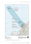
Sacred Island of Okinoshima and Associated Sites in the Munakata Region
Multiple Locations (8)
| ID | Name & Location | State Party | Coordinates | Property | Buffer Zone |
|---|---|---|---|---|---|
| 1535-001 | Okinoshima | Japan |
N34 14 42 E130 6 20 |
68.38 ha | 79,363.48 ha |
| 1535-002 | Koyajima | Japan |
N34 13 53 E130 6 42 |
1.89 ha | |
| 1535-003 | Mikadobashira | Japan |
N34 13 54 E130 6 50 |
0.15 ha | |
| 1535-004 | Tenguiwa | Japan |
N34 13 56 E130 6 51 |
0.19 ha | |
| 1535-005 | Okitsu-miya Yohaisho, Munakata Taisha | Japan |
N33 54 32 E130 25 41 |
0.24 ha | |
| 1535-006 | Nakatsu-miya, Munakata Taisha | Japan |
N33 53 50 E130 25 54 |
1.5 ha | |
| 1535-007 | Hetsu-miya, Munakata Taisha | Japan |
N33 49 47 E130 30 51 |
11.27 ha | |
| 1535-008 | Shimbaru-Nuyama Mounded Tomb Group | Japan |
N33 49 3 E130 29 10 |
15.31 ha |
Maps
| Date | Title | |
|---|---|---|
|
2017 | Sacred Island of Okinoshima and Associated Sites in the Munakata Region - Maps of the inscribed property |
Disclaimer
The Nomination files produced by the States Parties are published by the World Heritage Centre at its website and/or in working documents in order to ensure transparency, access to information and to facilitate the preparations of comparative analysis by other nominating States Parties.
The sole responsibility for the content of each Nomination file lies with the State Party concerned. The publication of the Nomination file does not imply the expression of any opinion whatsoever of the World Heritage Committee or of the Secretariat of UNESCO concerning the history or legal status of any country, territory, city or area or of its boundaries.