Prehistoric Sites of Talayotic Menorca
Multiple Locations (9)
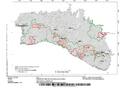
| ID | Name & Location | State Party | Coordinates | Property | Buffer Zone |
|---|---|---|---|---|---|
| 1528rev-001 | C1: Plains of Ciutadella | Spain |
N39 59 51 E03 54 32 |
440 ha | 15,635 ha |
| 1528rev-002 | C2: Southwest Area | Spain |
N39 56 21 E3 53 29 |
546 ha | |
| 1528rev-003 | C3: Western Migjorn area | Spain |
N39 57 25 E4 0 25 |
107 ha | |
| 1528rev-004 | C4: Central-south area of ravines | Spain |
N39 55 26 E4 3 23 |
667 ha | |
| 1528rev-005 | C5: Area between the ravines of Torrevella and Cala en Porter | Spain |
N39 53 6 E4 6 45 |
632 ha | |
| 1528rev-006 | C6: South-east area-Alaior | Spain |
N39 53 29 E4 9 44 |
502 ha | |
| 1528rev-007 | C7: South-east area-Maó | Spain |
N39 52 52 E4 12 58 |
104 ha | |
| 1528rev-008 | C8: Prehistoric village of Trepucó | Spain |
N39 52 26 E4 15 58 |
5 ha | |
| 1528rev-009 | C9: North-West area of Tramuntana | Spain |
N39 57 19 E4 15 13 |
524 ha | 3,379 ha |
Maps
Disclaimer
The Nomination files produced by the States Parties are published by the World Heritage Centre at its website and/or in working documents in order to ensure transparency, access to information and to facilitate the preparations of comparative analysis by other nominating States Parties.
The sole responsibility for the content of each Nomination file lies with the State Party concerned. The publication of the Nomination file does not imply the expression of any opinion whatsoever of the World Heritage Committee or of the Secretariat of UNESCO concerning the history or legal status of any country, territory, city or area or of its boundaries.