The Ahwar of Southern Iraq: Refuge of Biodiversity and the Relict Landscape of the Mesopotamian Cities
The Ahwar of Southern Iraq: Refuge of Biodiversity and the Relict Landscape of the Mesopotamian Cities
The Ahwar is made up of seven components: three archaeological sites and four wetland marsh areas in southern Iraq. The archaeological cities of Uruk and Ur and the Tell Eridu archaeological site form part of the remains of the Sumerian cities and settlements that developed in southern Mesopotamia between the 4th and the 3rd millennium BCE in the marshy delta of the Tigris and Euphrates rivers. The Ahwar of Southern Iraq – also known as the Iraqi Marshlands – are unique, as one of the world’s largest inland delta systems, in an extremely hot and arid environment.
Description is available under license CC-BY-SA IGO 3.0
Les Ahwar du sud de l’Iraq : refuge de biodiversité et paysage relique des villes mésopotamiennes
Il s’agit d’un ensemble de sept éléments constitutifs : trois sites archéologiques et quatre zones humides marécageuses situés dans le sud de l’Iraq. Les villes archéologiques d’Uruk et d’Ur et le site archéologique du Tell Eridu font partie des vestiges de villes et d’établissements sumériens qui se développèrent en Mésopotamie méridionale entre le IVe et le IIIe millénaire av. J.-C. dans le delta marécageux du Tigre et de l’Euphrate. Les Ahwar du sud de l’Iraq – également connus sous le nom de régions marécageuses d’Iraq – sont uniques, car il s’agit de l’un des plus grands deltas intérieurs du monde, dans un milieu extrêmement chaud et aride.
Description is available under license CC-BY-SA IGO 3.0
الأهوار جنوب العراق: تعد هذه المسطحات المائية مثالاً على التنوّع البيولوجي والمناظر الخلّابة لمدن بلاد الرافدين
يضم هذا المكان ستّة مواقع هي: ثلاثة مواقع أثريّة وأربعة مناطق رطبة ومستنقعات جنوب العراق. وتعد مدينتا أوروك وأور الأثريتين بالإضافة إلى الموقع الأثري في مدينة إريدو (تل أبو شهرين) جزءاً من آثار المدن والمباني السومريّة التي أنشئت في بلاد ما بين النهرين بين الألفيتين الرابعة والثالثة قبل الميلاد على ضفاف نهري دجلة والفرات. وتعدّ أهوار جنوب العراق، مناطق فريدة من نوعها حيث فيها أكبر دلتا داخلية في العالم في بيئة حارة وجافة للغاية.
source: UNESCO/CPE
Description is available under license CC-BY-SA IGO 3.0
伊拉克南部Ahwar:生态多样性避难所和美索不达米亚城市遗迹景观
位于伊拉克南部的Ahwar遗产地由七部分组成:三处考古遗址和四处湿地沼泽。Uruk和Ur的城市考古遗址和Tell Eridu考古遗址构成了美索不达米亚平原南部苏美尔文明的城市和聚居地遗迹,这一文明于公元前2000-3000年间在底格里斯河和幼发拉底河湿地三角洲地区兴盛。伊拉克南部Ahwar—也叫伊拉克沼泽十分独特,是极度炎热和干燥环境下世界上最大的内陆三角洲系统,。
source: UNESCO/CPE
Description is available under license CC-BY-SA IGO 3.0
Месопотамские болота на юге Ирака: центр биоразнообразия и реликтовые ландшафты городов Месопотамии
Данный объект состоит из семи элементов: трёх археологических объектов и четырёх водно-болотных территорий на юге Ирака. Древние города Урук и Ур, а также археологический объект Тель-Эриду входят в число сохранившихся руин шумерских городов и сооружений, возведённых в Южной Месопотамии между IV и III веками до н.э. в болотистых низовьях Тигра и Евфрата. Месопотамские болота на юге Ирака, также известные как болота аль-Ахвар, уникальны тем, что они образуют одну из самых больших в мире внутренних дельт, расположенную при этом в чрезвычайно жаркой и засушливой зоне.
source: UNESCO/CPE
Description is available under license CC-BY-SA IGO 3.0
Refugio de biodiversidad de los “ahwar” y paisaje arqueológico de las ciudades mesopotámicas del Iraq Meridional
Este sitio comprende tres áreas de vestigios arqueológicos y cuatro zonas de humedales pantanosos, situadas todas ellas en el sur de Iraq. El “tell” de Eridu y las ruinas de las ciudades de Uruk y Ur forman parte de los vestigios arqueológicos de asentamientos sumerios en la Baja Mesopotamia, que florecieron entre el tercer y cuarto milenios a.C. en el delta pantanoso formado por los ríos Éufrates y Tigris. Por su parte, las regiones de humedales pantanosos (“ahwar”) de esta región del Iraq Meridional son únicas en su género por deber su formación a uno de los mayores deltas interiores del mundo y por estar situadas en un medio natural extremadamente árido y cálido.
source: UNESCO/CPE
Description is available under license CC-BY-SA IGO 3.0
南イラクのアフワール:生物の避難所と古代メソポタミア都市景観の残影
'アフワールは、イラク南部の3つの考古学遺跡と4つの湿地帯からなる地域。都市遺跡ウルクとウル、およびエリドゥの遺丘は、チグリス川、ユーフラテス川の沼沢デルタ地帯において紀元前4千年紀から前3千年紀にかけ、南メソポタミアに展開したシュメール人の都市と定住地の痕跡の一部をなしている。「イラク湖沼地帯」とも呼ばれる南イラクのアフワールは、世界で最も大きな内陸デルタの一つで、極度に高温かつ乾燥した環境における、ほかに例を見ない場所である。source: NFUAJ
De Ahwar van Zuid-Irak: schuilplaats van biodiversiteit en archeologisch landschap van Mesopotamische steden
De Ahwar bestaat uit zeven locaties: drie archeologische sites en vier waterrijke moerasgebieden in Zuid-Irak. De archeologische steden Uruk en Ur, evenals de Tell van Eridu, zijn overblijfselen van Sumerische steden en nederzettingen die zich in Zuid-Mesopotamië ontwikkelden tussen het vierde en derde millennium voor Christus. De moerasdelta van de rivieren de Tigris en de Eufraat is een van 's werelds grootste inlandse deltasystemen in een extreem heet en droog klimaat.
Source: unesco.nl

Outstanding Universal Value
Brief Synthesis
The Ahwar of Southern Iraq evolved as part of the wider alluvial plain during the final stage of the alpine tectonic movement, which also led to the creation of the Zagros Mountains. Several factors intertwined to shape the property including; tectonic movements, climatic changes, river hydrology dynamics, precipitation variation, and changes in sea level. The sea level variation and the climatic changes had a significant role in influencing the quantity and quality of water entering the Ahwar through rivers and their branches, in addition to advancement and regression of the sea and intrusion during dry to semi-dry to wet conditions during the last 18,000 years.
Between 5000 and 3000 BC, sea water level reached its maximum extent some 200 km inland of the present coastline with marshes stretching further inland. The marshy and moving landscape of this deltaic plain was the heartland where the first cities flourished. Uruk, Ur and Eridu, the three cultural components of the property, were originally situated on the margins of freshwater marshes and developed into some of the most important urban centres of southern Mesopotamia. These cities saw the origin of writing, monumental architecture in the form of mudbrick temples and ziggurats, and complex technologies and societies. A vast corpus of cuneiform texts and archaeological evidence testifies to the centrality of the marshes for the economy, worldview and religious beliefs of successive cultures in southern Mesopotamia.
Starting in 2000 BC, the sea regressed towards the south. This led to another climatic change towards a more arid environment leading to the drying up of the ancient marshes and in turn to the decline of the great cities of southern Mesopotamia. Today the mudbrick ruins of Uruk, Ur and Eridu are dominated by the remains of ziggurats which still stand within the arid but striking landscape of the desiccated alluvial plain.
With the regression of the sea water, new marshes formed to the southeast. The main marshes of the Ahwar as we know them today were formed during this period around 3,000 years ago.
The Huwaizah, East and West Hammar and Central Marshes of the Ahwar are predominantely fed by the Tigris and Euphrates Rivers.
The Huwaizah Marshes component is a unique freshwater system, receiving high water quantities from floods and limited amounts of seasonal rain which descends from the northern and north-eastern heights. Concurrently, it is the sole natural component that was not drastically drained in the 1980s and 1990s, leading to the salvation of its key ecological elements. This led it to become the primary refuge for many of the key bird species of African and Indian origin in the Middle East, which have since spread back to other components after the reflooding took place in early 2000s.
The Central Marshes component comprises today's ecological core of the Ahwar. Being distinctive for its extensive ecosystems, it provides a vast habitat for many of the viable populations of taxa of high biodiversity and conservation importance.
The East and West Hammar Marshes components embrace a particular ecological phenomenon in contrast to the other components. Here, the salt water from the sea progresses inland affected on one side by tidal movements in the southern-most regions of marshes, while on the other side, pushing its way into the extended desert to the southeast. This creates very specific ecological conditions with marine fish species utilizing the area for reproduction in the East Hammar, while the West Hammar comprises the last stopover area for millions of migrating birds before entering the vast Arabian Desert.
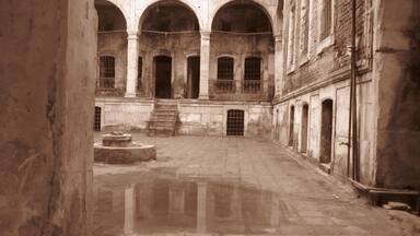
Criterion (iii): The remains of the Mesopotamian cities of Uruk, Ur and Eridu offer an outstanding testimony to the growth and subsequent decline of southern Mesopotamian urban centres and societies from the Ubaid and Sumerian periods until the Babylonian and Hellenistic periods. The three cities were major religious, political, economic and cultural centres which emerged and grew during a period of profound change in human history. These three components of the property bear witness to the contribution of southern Mesopotamian cultures to the development of ancient Near Eastern urbanized societies and the history of mankind as a whole: the construction of monumental public works and structures in the form of ziggurats, temples, palaces, city walls, and hydraulic works; a class structured society reflected in the urban layout which included royal tombs and palaces, sacred precincts, public storehouses, areas dedicated to industries, and extensive residential neighbourhoods; the centralized control of resources and surplus which gave rise to the first writing system and administrative archives; and conspicuous consumption of imported goods. This exceptionally creative period in human history left its marks across place and time.
Criterion (v): The remains of the ancient cities of Uruk, Ur and Eridu, today in the desert but originally situated near freshwater marshes which receded or became saline before drying up, best exemplify the impact of the unstable deltaic landscape of the Tigris and Euphrates upon the rise and fall of large urban centres. Testimonies of this relict wetland landscape are found today in the cities' topography as traces of shallow depressions which held permanent or seasonal marshes, dry waterways and canal beds, and settlement mounds formed upon what were once islets surrounded by marsh water. Architectural elements, archaeological evidence and an important corpus of cuneiform texts further document how the landscape of wetlands contributed to shaping the religious beliefs, cultic practices, and literary and artistic expressions of successive cultures in southern Mesopotamia.
Criterion (ix): The Huwaizah, East and West Hammar and Central Marshes demonstrate internationally significant ecological succession processes in one of the most arid inland deltas in the world, and contain a high degree of speciation in a relatively young ecosystem. It is one of the largest West Eurasian-Caspian-Nile staging points and wintering grounds for ducks as well as a major stopover point for shorebirds flying along the West Asian-East African flyway. It is also significant for the migration of fish and shrimp species from the Persian Gulf to the marshlands, with most of the fish species demonstrating diadromous characteristics (migratory between salt and fresh waters).
Criterion (x): The Huwaizah, East and West Hammar and Central Marshes contain highly important and significant habitats for in-situ conservation of biological diversity, including endemic, and restricted range species, and numerous populations of threatened species.
This includes bird species (e.g. the endemic Basra Reed Warbler and Iraq Babbler, restricted range subspecies of the Little Grebe, Black Francolin and Hooded Crow and the vulnerable Marbled Teal), mammals (e.g. the endemic Bunn’s Short-tailed Bandicot Rat, a subspecies of the Smooth-coated Otter, and the range-restricted Mesopotamian Gerbil and Euphrates Jerboa), as well as 6 range-restricted fish species. The property provides habitat for several reptiles including the Euphrates Soft-shell Turtle, an endangered species that is only known from a few localities in Iraq and Iran, and Murray's Comb-fingered Gecko which has a restricted range limited to the Ahwar, Shatt AI Arab and the Iranian western shores. The marshes also provide habitat for relict populations of three bird species (the African Darter, the Sacred Ibis, and the Goliath Heron) that are thousands of kilometres away from their core global populations in Africa.
Integrity
The three archaeological ensembles included in the property offer a comprehensive picture of the Ubaid and Sumerian urbanization process within their original but now dried marshland setting. Almost all the major archaeological and architectural features of Eridu, Uruk, and Ur are contained within the boundaries of the property but some are in the buffer zone and beyond. In Ur, the main harbour, situated outside the boundaries of the property, has yet to be excavated and the boundaries of the property might be extended at a later stage to include it.
The use of mud as the main building material in southern Mesopotamia creates specific conservation conditions. The toll which the passing of time took on the abandoned southern Mesopotamian cities is heavier than in the case of stone or fired brick architecture found in other regions of the ancient world where remains can be monumental and visually impressive. Yet the remains of the four ziggurats of Eridu, Uruk and Ur, however eroded, still tower over the desert landscape and provide a striking visual testimony of the antiquity and durability of the most emblematic architectural features of Mesopotamian cities.
Layers of sedimentation protected the remains of Uruk, Ur and Eridu until the 20th century when archaeological excavations exposed several buildings anew. Eridu's excavated remains were later reburied except for the ziggurat. In Uruk and Ur there were some instances of incompatible material used to consolidate or protect the remains, whereas others were left exposed with no maintenance or protection between the 1930s and 1960s with the result that some have become affected by erosion caused mainly by rain and dust storms. Only Ur has suffered limited, but reversible, damages during the recent conflict.
Overall the integrity of the three cities is vulnerable: the conservation of their exposed fabric needs urgent attention to halt further irreversible erosion and collapse.
The four wetland components of the property cover an area of over 210,000 ha an additional 200,000 ha of buffer zones surrounding each of the four components provide further protection of the property on a whole as well as at the component level. Considering that these components are ecologically interdependent, there is a need to establish a set of ecological corridors to ensure connectivity of the serial property.
The most notable threat to the property's ecological integrity pertains to water flows fluctuating significantly with the continued adequacy of flows in the future uncertain. There is a need to ensure that the minimum water flow is guaranteed for the property to sustain its biodiversity and ecological processes. More broadly, there is a need to conduct further studies to confirm the plant, vertebrate and invertebrate diversity within the property and its surrounding landscapes.
The four components embrace the majority of the breeding grounds of key bird species within different regions of the property. The breeding grounds are areas of low human intervention where reed vegetation is used to build nests on the banks of the small islets abundant in the area which are surrounded with extensive water bodies located in isolation from the dry lands and away from potential predators.
Numerous populations of more than 197 species of migrating water birds associated with the Palearctic region settle on the property and spend winter periods here during their west Eurasia-Caspian-Nile and Eurasian-Africa route migrations. The numbers of migrating birds utilizing the property is increasing, paralleling the improving levels of rehabilitation. Further, increasing numbers of globally threatened species are being documented.
Authenticity
In terms of material authenticity of the three urban archaeological sites, excavations of a series of emblematic public buildings allow for a good understanding of the spatial organization of the political, administrative and religious sections of the cities. Although there is no doubt of the link between the fabric and what they convey, that link is extremely vulnerable for some areas, where past lack of conservation and maintenance has caused irreversible erosion of the mud and burnt brick fabric and the potential collapse of some structures. The stage could soon be reached where vital evidence has been eroded.
No major restoration or conservation projects have been carried out since the 1930s with the exception of the 1960s rebuilding of part of the outer shell of the Ur ziggurat using baked brick and limited amounts of cement. This intervention did not affect the original structure and shape of the monument but cracks in the cement are leading to water ingress. More recent conservation of the site has been done using compatible material as much as possible.
Overall the authenticity of the three cities is highly vulnerable due to a legacy of poor protection, maintenance and conservation.
Protection and management requirements
The overarching governance of the property is ensured by the National Committee for managing the Ahwar of Southern Iraq as a World Heritage Property. The committee is led by the Minister of Water Resources and includes the Ministry of Culture (State Board of Antiquities and Heritage), the Ministry of Health (Department of Environment), the Ministry of Oil, the Ministry of Agriculture, and other concerned ministries. The committee coordinates all governmental decisions of relevance to the property, including budgetary allocation and implementation steps of the 2015 Consolidated Management Plan developed for the property.
Uruk, Ur and Eridu are protected by the Antiquities and Heritage Law no. 55 of 2002 which takes precedence over any other public law, and each are registered in the Official Gazette as separate archaeological sites with their own boundaries and buffer zones corresponding to those of the component sites of the property.
The Iraqi State Board of Antiquities and Heritage (SBAH) has been working in partnership with foreign archaeological missions to start implementing the provisions of the management plan concerning specifically the three archaeological ensembles. Priorities include staff training and capacity-building together with surveys and conservation of the most unstable monuments and areas in each archaeological site. Furthermore, a monitoring system has been put in place to cover the three component sites and their buffer zones covering all factors that may affect their integrity and authenticity. Two dedicated management teams have been set up: one overseeing work at Uruk, the other in charge of Ur and Eridu. These teams report to the provincial Directorates of Antiquities and Heritage (DAH): The Dhi Qar DAH has jurisdiction over Ur and Eridu, whereas the Muthanna DAH has jurisdiction over Uruk. DAHs are assisted by the Antiquity and Heritage Police, created in 2007 for monitoring archaeological sites. The Antiquity and Heritage Police maintains a permanent presence at Uruk and Ur and regularly patrol at Eridu.
In order to address the highly unstable conservation conditions of the three cities, a programme of surveys will be undertaken to create a base-line delineation of the state of conservation of the property; a conservation programmes will be developed for all three cities on the basis of the surveys that clearly set out the various options for intervention in advance of conservation work commencing; and a detailed master plan/road map will be produced that ensures the conservation of the property on a sustainable basis.
The Huwaizah, East and West Hammar and Central Marshes have all been designated as Ramsar sites and their protection falls under the responsibility of the Ministry of Water Resources. Each marshland component has been allocated dedicated management staff who report to project management of Water Resources in the provinces of Dhi Qar, Maysan and Basra. In this case too, the provisions of the 2015 Consolidated Management Plan give priority to staff training and capacity-building in all areas relevant for the conservation of the property's natural value. The management plan also addresses the involvement of local stakeholders in the decision-making process, and the ability of local communities to improve their living conditions and preserve their traditional way of life. Furthermore, The Ministry of Water Resources (MWR) has just completed its "Strategy for Water and Land Resources in Iraq (SWRLI)" which covers the period until the year 2035. This strategy outlines the path towards integrated land and water management in light of the prevailing physical, hydrological and climatic conditions. It also examined the water-food-energy nexus in Iraq and recommended major investment plans in response to the adaptation measures to climate change and other development requirements.
SWRLI recognizes the Iraqi marshlands as a legitimate "water user" on an equal footing with agriculture, domestic and industrial uses. This is a major step forward in the strategy catering for the minimum water requirement for the environment.
Current annual and seasonal operational plans of the Iraqi water system managed by MWR seek to incorporate the minimum water flows allocated to the southern Iraqi marshlands, including the four marsh components of the property. An amount of 5.8 BCM (billion cubic meters) of water is allocated on a yearly basis for the marshland and is being incorporated in the operations of the water system. However, water flows are known to fluctuate significantly on an annual basis and therefore it is crucial that minimum water flow is generated and sustained in the long term.
A complex modelling exercise has been carried out by the Center for Restoration of Iraqi Marshes and Wetlands (CRIMW) to simulate the hydrology of southern Iraq. The simulations are aimed at determining the minimum monthly water flows required for the four marsh components of the property to sustain the biodiversity and ecological processes. Major sustained efforts are however needed to better understand the hydrological regimes including defining minimum water requirements for the preservation of the natural value.
Regional issues such as dam projects, intensification of irrigation, pollution and drought in a changing climate remain challenges that have to be systematically considered as they will increase the pressure on these fragile wetlands. In addition, clarification and regulation measures need to be put in place in buffer zones where potential oil extraction activities could constitute an important threat to the integrity of the Ahwar. Finally, the impact of agricultural, fishing and hunting activities on ecosystems has to be adequately regulated. Tourism does not constitute a current threat but could have a larger influence in the medium term.
The boundaries of the four natural components and associated buffer zones provide protection against threats, such as oil exploration and urban development. However, enhanced efforts are needed to review boundaries and ensure that all components remain hydrologically and wherever possible ecologically connected.
Staffing remains inadequate for the property hence the recruitment and management of increased human resources, in particular the site manager, site rangers and site guides, is paramount. Management of the property requires strengthening in a way that considers traditional use and the dependency of communities on the natural components of the property.


Protections
by other conservation instruments
1 protection / 1 element
2003 Convention for the Safeguarding of the Intangible Cultural Heritage (1 element)