Rock Islands Southern Lagoon
Rock Islands Southern Lagoon
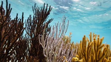
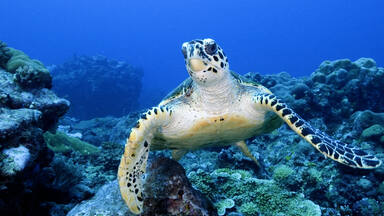
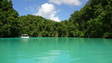
Rock Islands Southern Lagoon covers 100,200 ha and includes 445 uninhabited limestone islands of volcanic origin. Many of them display unique mushroom-like shapes in turquoise lagoons surrounded by coral reefs. The aesthetic beauty of the site is heightened by a complex reef system featuring over 385 coral species and different types of habitat. They sustain a large diversity of plants, birds and marine life including dugong and at least thirteen shark species. The site harbours the highest concentration of marine lakes anywhere, isolated bodies of seawater separated from the ocean by land barriers. They are among the islands’ distinctive features and sustain high endemism of populations which continue to yield new species discoveries. The remains of stonework villages, as well as burial sites and rock art, bear testimony to the organization of small island communities over some three millennia. The abandonment of the villages in the 17th and 18th centuries illustrates the consequences of climate change, population growth and subsistence behaviour on a society living in a marginal marine environment.
Description is available under license CC-BY-SA IGO 3.0
Lagon sud des îles Chelbacheb
Ce site de 100 200 hectares compte 445 îlots calcaires inhabités. D’origine volcanique, les îlots ont souvent la forme de champignons entourés de lagons couleur turquoise et de récifs coralliens. La beauté du site est renforcée par un système complexe de récifs comptant 385 espèces de coraux et différents types d’habitat. Ces derniers hébergent une grande variété de plantes, d’oiseaux et d’animaux marins, notamment des dugongs et au moins treize espèces de requins. Le site représente la plus grande concentration de lacs marins au monde. Ces masses d’eau de mer, isolées de l’océan par une barrière terrestre, sont caractéristiques de ces îles et se traduisent par un endémisme élevé qui peut laisser espérer la découverte de nouvelles espèces. Les vestiges des villages en pierre, ainsi que l’art rupestre et les sépultures, apportent un témoignage exceptionnel sur l’organisation des communautés des petites îles pendant plus de trois millénaires. L’abandon des villages des îles Chelbacheb aux XVIIe et XVIIIe siècles illustre les conséquences du changement climatique, de l’essor démographique et du comportement de subsistance dans une société vivant dans un environnement marin marginal.
Description is available under license CC-BY-SA IGO 3.0
Laguna meridional de las Islas Rocosas
Este sitio micronesio de 100.200 hectáreas comprende 445 islotes calcáreos de origen volcánico, totalmente despoblados, que en muchos casos tienen forma de hongos rodeados por lagunas de aguas color turquesa y arrecifes coralinos. La belleza del sitio la realza la existencia de un complejo sistema de arrecifes con 385 especies diferentes de corales y diferentes tipos de hábitat, que albergan una gran variedad de plantas, aves y animales marinos como los dugongos y 13 especies de tiburones por lo menos. En este sitio se da la mayor concentración mundial de lagos marinos, esto es, de masas de agua de mar separadas del océano por barreras terrestres. Característicos de estas islas, esos lagos son el sustrato de un endemismo elevado que puede abrir paso al descubrimiento de nuevas especies.
source: UNESCO/CPE
Description is available under license CC-BY-SA IGO 3.0
南ラグーンのロックアイランド群
パラオ南西部に浮かぶロック諸島の南ラグーンは、石灰岩の大小の島々と周囲のサンゴ礁からなる。445に及ぶサンゴ礁由来の島々は火山活動による隆起によって誕生し、淡水湖と海水湖からなる52の海洋湖は「生物進化の実験室」と呼ばれるほど多様な性質を持つ。746種の魚類、385種のサンゴ、13種のサメとマンタが生息する水域は、新種が次々と見つかる生物多様性の宝庫。現在は無人島だが、紀元前3100年から2500年間にわたって人が住み、洞窟や岩絵、墓など生活の痕跡があることから、複合遺産に登録された。source: NFUAJ
Zuidelijke lagune van de Rock Islands
De Rock Eilanden in de Zuidelijke lagune beslaan 100.200 hectare en omvatten 445 onbewoonde kalkstenen eilanden van vulkanische oorsprong. Veel van de eilanden hebben unieke paddenstoelachtige vormen in turkooiskleurige lagunes, omringd door koraalriffen. De esthetische schoonheid van het gebied wordt verhoogd door een complex rifsysteem met meer dan 385 soorten koralen en verschillende typen leefklimaat. Ze houden een grote diversiteit aan planten, vogels en zeedieren in stand waaronder zeekoeien en ten minste dertien haaiensoorten. Het gebied kent de grootste concentratie mariene meren; geïsoleerde delen zeewater door landbarrières gescheiden van de oceaan. De overblijfselen van stenen dorpen, begraafplaatsen en rotsschilderingen getuigen van bewoning gedurende zo'n drie millennia.
Source: unesco.nl

Outstanding Universal Value
Brief synthesis
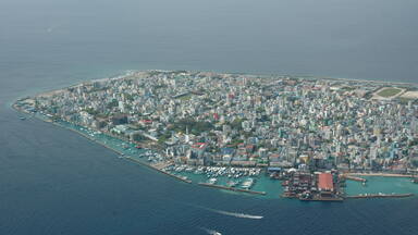
The Rock Islands Southern Lagoon consists of numerous large and small forested limestone islands, scattered within a marine lagoon protected by a barrier reef. The property lies within Koror State, immediately to the south of Palau’s main volcanic island Babeldaob in the western Pacific Ocean.
The marine site covers 100,200 ha and is characterized by coral reefs and a diversity of other marine habitats, as well as 445 coralline limestone islands uplifted due to volcanism and shaped over time by weather, wind and vegetation. This has created an extremely high habitat complexity, including the highest concentration of marine lakes in the world, which continue to yield new species discoveries. The terrestrial environment is lush and at the same time harsh, supporting numerous endemic and endangered species. Although presently uninhabited, the islands were once home to Palauan settlements, and Palauans continue to use the area and its resources for cultural and recreational purposes. This is regulated through a traditional governance system that remains an important part of national identity.
The islands contain a significant set of cultural remains relating to an occupation over some five thousand years that ended in abandonment. Archaeological remains and rock art sites are found in two island clusters - Ulong and Negmelis, and on three islands - Ngeruktabel, Ngeanges, and Chomedokl.
Remains of former human occupation in caves, including rock art and burials, testifies to seasonal human occupation and use of the marine ecosystem, dating back to 3,100 BP and extending over some 2,500 years.
Permanent stone villages on a few islands, some dating back to between 950 and 500 BP, were occupied for several centuries before being abandoned in the 17th-18th centuries, when the population moved to larger islands. The villages include the remains of defensive walls, terraces and house platforms. The settlements reflect distinctive responses to their local environment and their abandonment demonstrates the consequences of population growth and climate change impacting on subsistence in a marginal environment.
The descendants of the people who moved from the Rock Islands to the main islands of Palau identify with their ancestral islands through oral traditions that record in legends, myths, dances, and proverbs, and traditional place names the land- and seascape of their former homes.
The abandoned islands now provide an exceptional illustration of the way of life of small island communities over more than three millennia and their dependence on marine resources. They also are seen as ancestral realms by the descendants of those who migrated to the main island of Palau and this link is kept alive through oral traditions.
Criterion (iii): The Rock Islands cave deposits, burials, rock art, abandoned remains of stonework villages and middens bear exceptional testimony to the organisation of small island communities and their harvesting of marine resources over some three millennia.
Criterion (v): The abandonment of Rock Island villages in the 17th and 18th centuries demonstrated by the remains of human settlement and evidence of marine harvesting activity in the Rock Islands Southern Lagoon is an exceptional illustration of the intersection and consequences of climate change, population growth, and subsistence behaviour on a society living in a marginal marine environment.
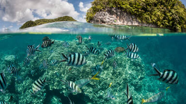
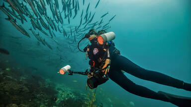
Criterion (vii): The Rock Islands Southern Lagoon contains an exceptional variety of habitats within a relatively limited area. Barrier and fringing reefs, channels, tunnels, caves, arches, and coves, as well as the highest number and density of marine lakes in the world, are home to diverse and abundant marine life. The maze of dome-shaped and green Rock Islands seemingly floating in the turquoise lagoon surrounded by coral reef is of exceptional aesthetic beauty.
Criterion (ix): The Rock Islands Southern Lagoon contains 52 marine lakes, more than at any other site in the world. Furthermore, the marine lakes of the property are at different stages of geological and ecological development, ranging from lakes with high connectivity to the sea to highly isolated lakes with notably different species composition, including unique and endemic species. These features represent an outstanding example of how marine ecosystems and communities develop, and make the lakes valuable as “natural laboratories” for scientific study of evolution and speciation. Five new subspecies of the Mastigias papua jellyfish have been described from these marine lakes, and new species discoveries continue to be made both in the marine lakes as well as in the complex reef habitats of the property.
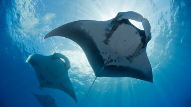
Criterion (x): The Rock Islands Southern Lagoon has exceptionally high biological and marine habitat diversity. The marine lakes are unique in terms of number, the density at which they occur, and their varying physical conditions. With low fishing pressure, limited pollution and human impact, as well as an exceptional variety of reef habitat, the resilience of reefs of the property makes it a critical area for protection, including as an area important for climate change adaptation of reef biota, and potentially as a source of larvae for reefs in the region. All the endangered megafauna of Palau, 746 species of fish, over 385 species of corals, at least 13 species of sharks and manta rays, 7 species of giant clams, and the endemic nautilus are found in the property, and the forests of the islands include all of Palau’s endemic birds, mammals, herpetofauna and nearly half of Palau’s endemic plants. This makes the area of exceptional conservation value.
Integrity
The property has clear boundaries and includes a large part of the lagoonal and reef habitat surrounding the main islands of Palau, as well as most land of coralline origin occurring within Koror State. This ensures a high degree of replication of habitat type. Although past and present use has altered both marine and terrestrial environments, or at least the abundance of resource species, the present conservation status of the property is good. Activities in and around the property that may impact on it are subject to specific management regulations and/or interventions. The inclusion of waters outside the barrier reef and within Koror State jurisdiction in a buffer zone further increases its ecological integrity.
The property contains a complete representation of the features and processes that convey the value of the property. Most of these elements do not suffer inordinately from development or neglect and are in good condition. However a conservation programme is required to ensure ongoing conservation and maintenance. The property has been largely isolated from human interference since pre-European occupation ceased. They are nevertheless highly vulnerable to uncontrolled tourism activities.
Authenticity
The form and materials of village settlements, burial caves and their setting continue to convey the cultural value of the property. Excavated deposits have been recorded and reburied, and the reports of these campaigns have been lodged with the Koror State Government. To achieve a full understanding of the remains on all the islands will need more survey work.
Oral histories and ongoing cultural traditions in the main island of Palau keep alive the memories of the migration away from the Rock Islands and the histories associated with them.
Protection and management requirements
The legislative framework regulating use and management of the environment and its resources is comprehensive and clear. The area falls in its entirety in Koror State, and the management jurisdiction of Koror State Rangers is well known and respected. Management authorities are operating on relatively reliable revenue from tourism. The strength of traditional value systems including resource governance systems is an asset, and can enable management and zoning that accommodate both cultural/traditional and biodiversity conservation needs. Management objectives and priorities are defined in the Rock Islands Southern Lagoon Management Plan. Both legislative framework and management arrangements are conducive to protecting and maintaining the values of the property.
Cultural sites within the Rock Islands Southern Lagoon are protected under Title 19 ‘Cultural Resources’ by the Historical and Cultural Preservation Act of the Republic of Palau. Underwater archaeological and historical remains are protected under Title 19 as the ‘Palau Lagoon Monument’. All the designated sites within the property should be included on Palau’s National Register of historic places.
The Koror State Department of Conservation and Law Enforcement collaborates with the Palau Historic Preservation Office, Bureau of Arts and Culture in working with locally based agencies and organisations on management and research activities within the property. Koror State Regulations (1994) cover general resource use, recreational activities and the designation of protected areas within the Rock Islands Southern Lagoon. The Rock Islands Use Act was legislated in 1997 to regulate tourist activity in the islands. The laws and regulations are enforced by the Koror State Rangers.
The Rock Islands Southern Lagoon Area Management Plan 2004-2008 was adopted by the Koror State Legislature and Governor in 2005 and is currently under review.
Long term protection and management requirements for the property include the need to prevent negative impacts from tourism, including maintaining access restrictions to vulnerable areas, ensuring visitor numbers are within the capacity of the property, and mitigating adverse effects from development of infrastructure and facilities in Koror. Subsistence and recreational fishing taking place within the property and in designated zones require constant monitoring. However, the property may also be constructively used for research on and preservation of traditional knowledge of the marine environment. Additional needs include maintaining restrictions on development, including aquaculture, within the property and in the vicinity of property boundaries. An adaptive approach to management of the property and the provision for effective long term monitoring including ecosystem health and water quality are necessary in order to maintain the resilience of the property in the face of climate change.