Sacred Mijikenda Kaya Forests
Multiple Locations (8)
| ID | Name & Location | State Party | Coordinates | Property | Buffer Zone |
|---|---|---|---|---|---|
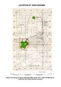
| 1231rev-001 | Kaya Giriama | Kenya |
S3 47 55.00 E39 30 52.00 |
204 ha | — |
| 1231rev-002 | Kaya Jibana | Kenya |
S3 50 15.00 E39 40 10.00 |
140 ha | — |
| 1231rev-003 | Kaya Kambe | Kenya |
S3 51 49.00 E39 39 7.00 |
75 ha | — |
| 1231rev-004 | Kaya Kauma | Kenya |
S3 37 14.00 E39 44 10.00 |
75 ha | — |
| 1231rev-005 | Kaya Ribe | Kenya |
S3 53 49.00 E39 37 58.00 |
36 ha | — |
| 1231rev-006 | The Rabai Kayas | Kenya |
S3 55 55.00 E39 35 46.00 |
580 ha | — |
| 1231rev-007 | The Duruma Kayas | Kenya |
S3 59 54.00 E39 31 25.00 |
398 ha | — |
| 1231rev-008 | Kaya Kinondo | Kenya |
S4 23 36.00 E39 32 41.00 |
30 ha | — |
Maps
| Date | Title | |
|---|---|---|
|
2008 | Mijikenda Kaya, Locations of Kaya Giriama, Kaya Kinondo, Kaya Jibana, Kaya Kambe and Kaya Ribe, Kaya Kauama, Kayas Rabai and Duruma |
Disclaimer
The Nomination files produced by the States Parties are published by the World Heritage Centre at its website and/or in working documents in order to ensure transparency, access to information and to facilitate the preparations of comparative analysis by other nominating States Parties.
The sole responsibility for the content of each Nomination file lies with the State Party concerned. The publication of the Nomination file does not imply the expression of any opinion whatsoever of the World Heritage Committee or of the Secretariat of UNESCO concerning the history or legal status of any country, territory, city or area or of its boundaries.