Inventory and cultural mapping of Sultanate’s architectural and urban heritage
In 2008 the NGO “Collectif du patrimoine des Comores” launched an inventory and cultural mapping project of the architectural and urban heritage of the Sultanates of the Comoros, with technical and financial support from the World Heritage Centre within the framework of the France-UNESCO Cooperation Agreement.
The Comoros put the Historic Sultanates on their Tentative List in 2007.
In order to better understand and safeguard the architectural, urban and landscape heritage of the Comoros, a cultural heritage inventory was produced. This cultural mapping project aims to create the required documentation to establish a corpus of graphic documents useful to the understanding and safeguarding, conservation and protection of heritage as well as to develop strategic planning tools.
This project was carried out by the Ecole Nationale Supérieure d’Architecture et du Paysage de Lille, ENSAPL (school of architecture and landscape in Lille), under the direction of Suzanne Hirschi, architect and professor at the ENSAPL, and Chéhrazade Nafa, architect, town planner and heritage specialist, and with the support of the “Collectif du Patrimoine des Comores”, an NGO dedicated to the valorization and protection of cultural and architectural heritage in the Comoros. Logistical and financial support was provided locally from the Comorian State and at the international level from the World Heritage Centre within the framework of the France-UNESCO Cooperation Agreement with the support of the French Ministry of Culture.
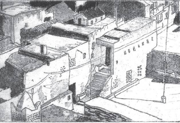
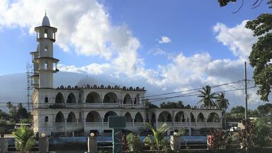
The data collecting and field work was carried out in nine sites spread out on the three islands of the Union of the Comoros. The main mission took place in May 2008, and allowed a group of six students from the ENSAPL and the University of the Comoros to make an exhaustive heritage census on six sites: Moroni, Iconi, Itsandra, Ndruwani and Domoni, identified by the Union of the Comoros as representative examples of historic Sultanates of the Comoros. Starting from 2011, four individual missions have explored three more sites: Bambao, Ntsudjini and Fomboni. In total, 238 elements were identified, described, mapped out and listed per geographic entities, by islands and cities. Each city entity is localised and introduced by a brief description, an aerial view and a general view of the city. Maps were drawn up for each city to provide an overview of the urban structure and to map the localisation of a set of physical elements of architectural urban value, which are further described by typology (streets, public places, palaces, houses, mosques etc.). Some of these elements are further identified and documented in details, individually, in specific datasheets. Each of these datasheets provides information on the name and type of the property, its localisation, as well as exterior and interior views, and details.
Further studies and identification of sources and archives should be carried out to provide more detailed historical material. This documentation could be used for the preparation of a nomination proposal for the World Heritage List.

 Comoros