Hattusha: the Hittite Capital
Multiple Locations (4)
| ID | Name & Location | State Party | Coordinates | Property | Buffer Zone |
|---|---|---|---|---|---|
| 377-001 | Hattousa [and Ibikçam Forest] | Türkiye |
N40 0 50.00 E34 37 14.00 |
262 ha | |
| 377-002 | Yazilikaya (rupestral sanctuary) | Türkiye |
N40 1 27.80 E34 38 15.80 |
1.8 ha | |
| 377-003 | Kayali Bogaz (outpost) | Türkiye |
N40 0 11.60 E34 38 14.00 |
4.5 ha | |
| 377-004 | Osmankayasi (rock necropolis) | Türkiye |
N40 1 26.50 E34 37 38.30 |
0.16 ha |
Maps
| Date | Title | |
|---|---|---|
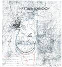
|
2009 | Hattuşa – Boğazköy Clarification / adopted |
Disclaimer
The Nomination files produced by the States Parties are published by the World Heritage Centre at its website and/or in working documents in order to ensure transparency, access to information and to facilitate the preparations of comparative analysis by other nominating States Parties.
The sole responsibility for the content of each Nomination file lies with the State Party concerned. The publication of the Nomination file, including the maps and names, does not imply the expression of any opinion whatsoever of the World Heritage Committee or of the Secretariat of UNESCO concerning the history or legal status of any country, territory, city or area or of its boundaries.