Göreme National Park and the Rock Sites of Cappadocia
Multiple Locations (7)
| ID | Name & Location | State Party | Coordinates | Property | Buffer Zone |
|---|---|---|---|---|---|
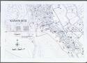
| 357-001 | Göreme National Park | Türkiye |
N38 40 0.00 E34 51 0.00 |
9,572 ha | |
| 357-002 | Karain site | Türkiye |
N38 35 41.00 E34 59 55.70 |
0.77 ha | |
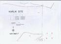
| 357-003 | Karlik site | Türkiye |
N38 34 25.00 E34 59 53.60 |
0.51 ha | |
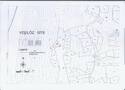
| 357-004 | Yesilöz site | Türkiye |
N38 33 15.80 E35 0 13.10 |
0.58 ha | |
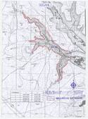
| 357-005 | Soganli site | Türkiye |
N38 24 40.40 E34 54 13.40 |
309 ha | |
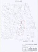
| 357-006 | Subterranean city of Kaymakli | Türkiye |
N38 28 9.00 E34 46 48.30 |
0.7 ha | |
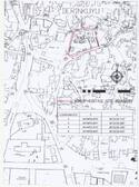
| 357-007 | Subterranean city of Derinkuyu | Türkiye |
N38 24 20.40 E34 45 27.50 |
0.25 ha |
Maps

Disclaimer
The Nomination files produced by the States Parties are published by the World Heritage Centre at its website and/or in working documents in order to ensure transparency, access to information and to facilitate the preparations of comparative analysis by other nominating States Parties.
The sole responsibility for the content of each Nomination file lies with the State Party concerned. The publication of the Nomination file does not imply the expression of any opinion whatsoever of the World Heritage Committee or of the Secretariat of UNESCO concerning the history or legal status of any country, territory, city or area or of its boundaries.