Ancient Villages of Northern Syria
Multiple Locations (8)
| ID | Name & Location | State Party | Coordinates | Property | Buffer Zone |
|---|---|---|---|---|---|
| 1348-001 | Jebel Sem’an 1 [Qal’atSem’an] | Syrian Arab Republic |
N36 20 3 E36 50 39 |
3,700 ha | — |
| 1348-002 | Jebel Sem’an 2 [KafrNabo] | Syrian Arab Republic |
N36 21 36 E36 54 29 |
2,760 ha | — |
| 1348-003 | Jebel Sem’an 3 [Sinkhar] | Syrian Arab Republic |
N36 17 51 E36 54 29 |
380 ha | — |
| 1348-004 | Jebel Zawiyé 1 [Ba’uda] | Syrian Arab Republic |
N35 40 11 E36 34 7 |
3,200 ha | — |
| 1348-005 | Jebel Zawiyé 2 [Rouweiha] | Syrian Arab Republic |
N35 44 18 E36 41 43 |
530 ha | — |
| 1348-006 | Jebelal-A’la [QalbLozé] | Syrian Arab Republic |
N36 10 9 E36 34 51 |
460 ha | — |
| 1348-007 | Jebel Barisha [Deirouné] | Syrian Arab Republic |
N36 12 38 E36 39 35 |
580 ha | — |
| 1348-008 | Jebel Wastani [Kafr Aqareb] | Syrian Arab Republic |
N36 2 3 E36 26 26 |
680 ha | — |
Maps
| Date | Title | |
|---|---|---|
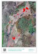
|
2011 | Villages antiques du Nord de la Syrie - bien inscrit |
Disclaimer
The Nomination files produced by the States Parties are published by the World Heritage Centre at its website and/or in working documents in order to ensure transparency, access to information and to facilitate the preparations of comparative analysis by other nominating States Parties.
The sole responsibility for the content of each Nomination file lies with the State Party concerned. The publication of the Nomination file does not imply the expression of any opinion whatsoever of the World Heritage Committee or of the Secretariat of UNESCO concerning the history or legal status of any country, territory, city or area or of its boundaries.