Stone Circles of Senegambia
Multiple Locations (4)
| ID | Name & Location | State Party | Coordinates | Property | Buffer Zone |
|---|---|---|---|---|---|
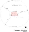
| 1226-001 | Kerbatch | Gambia |
N13 45 0.00 W15 0 0.00 |
0.79 ha | 20.19 ha |
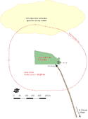
| 1226-002 | Wassu | Gambia |
N13 42 0.00 W14 52 0.00 |
1.63 ha | 25.29 ha |
| 1226-003 | Sine Ngayène | Senegal |
N13 40 60.00 W15 31 0.00 |
5.26 ha | 35.22 ha |
| 1226-004 | Wanar | Senegal |
N13 46 28.00 W15 31 21.00 |
2.17 ha | 29.35 ha |
Maps
| Date | Title | |
|---|---|---|
|
2005 | Map showing the boundaries of Kerbatch |
|
2005 | Map showing the boundaries of Wassu |

|
2005 | Map showing the boundaries of Sine Ngayène |

|
2005 | Map showing the boundaries of Wanar |
Disclaimer
The Nomination files produced by the States Parties are published by the World Heritage Centre at its website and/or in working documents in order to ensure transparency, access to information and to facilitate the preparations of comparative analysis by other nominating States Parties.
The sole responsibility for the content of each Nomination file lies with the State Party concerned. The publication of the Nomination file does not imply the expression of any opinion whatsoever of the World Heritage Committee or of the Secretariat of UNESCO concerning the history or legal status of any country, territory, city or area or of its boundaries.