Rideau Canal
Multiple Locations (6)
| ID | Name & Location | State Party | Coordinates | Property | Buffer Zone |
|---|---|---|---|---|---|
| 1221-001 | Rideau Canal | Canada |
N44 59 39.79 W75 45 54.45 |
21,427.07 ha | 2,334.78 ha |
| 1221-002 | Fort Henry, Kingston | Canada |
N44 13 51.41 W76 27 35.70 |
23.9 ha | 11.88 ha |
| 1221-003 | Fort Frederick, Kingston | Canada |
N44 13 40.64 W76 28 10.61 |
3.1 ha | 3 ha |
| 1221-004 | Cathcart Tower, Cedar Island | Canada |
N44 13 31.00 W76 27 14.00 |
0.25 ha | 9.15 ha |
| 1221-005 | Shoal Tower,Kingston | Canada |
N44 13 43.88 W76 28 41.00 |
0.32 ha | 1.68 ha |
| 1221-006 | Murney Tower, Kingston | Canada |
N44 13 19.71 W76 29 25.22 |
0.17 ha | 2.71 ha |
Maps
| Date | Title | |
|---|---|---|

|
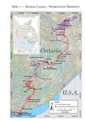
2006 | Map 1. Rideau Canal. Nominated property. |
|
2007 | Rideau Canal - maps of inscribed property |
Disclaimer
The Nomination files produced by the States Parties are published by the World Heritage Centre at its website and/or in working documents in order to ensure transparency, access to information and to facilitate the preparations of comparative analysis by other nominating States Parties.
The sole responsibility for the content of each Nomination file lies with the State Party concerned. The publication of the Nomination file, including the maps and names, does not imply the expression of any opinion whatsoever of the World Heritage Committee or of the Secretariat of UNESCO concerning the history or legal status of any country, territory, city or area or of its boundaries.