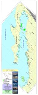
Islands and Protected Areas of the Gulf of California
Multiple Locations (12)
| ID | Name & Location | State Party | Coordinates | Property | Buffer Zone |
|---|---|---|---|---|---|
| 1182-001 | Islands of the Gulf of California | Mexico |
N29 0 0.00 W112 19 60.00 |
358,000 ha | — |
| 1182-002 | Upper Gulf of California - Colorado River Delta (marine portion) | Mexico |
N31 37 0.00 W114 36 0.00 |
86,638 ha | 454,591 ha |
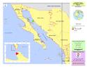
| 1182-003 | Isla San Pedro Martir | Mexico |
N28 22 30.00 W112 20 15.00 |
1,111 ha | 29,054 ha |
| 1182-004 | El Vizcaíno (marine and coastal belt in the Gulf of California) | Mexico |
N27 28 18.97 W113 36 16.41 |
49,451 ha | |
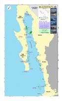
| 1182-005 | Bahía de Loreto | Mexico |
N25 50 35.00 W111 13 0.00 |
206,581 ha | — |
| 1182-006 | Cabo Pulmo | Mexico |
N23 27 0.00 W109 25 0.00 |
7,111 ha | — |
| 1182-007 | Cabo San Lucas | Mexico |
N22 52 0 W109 52 0 |
3,996 ha | — |
| 1182-008 | Islas Marias | Mexico |
N21 34 60 W106 31 60 |
14,845 ha | 626,440 ha |
| 1182-009 | Isla Isabel | Mexico |
N21 51 0.00 W105 52 60.00 |
194 ha | — |
| 1182-010bis | Archipelago of San Lorenzo | Mexico |
N28 38 25.77 W112 49 33.62 |
8,806 ha | 49,637 ha |
| 1182-011bis | Islas Marietas | Mexico |
N20 41 53.05 W105 35 10.85 |
79 ha | 1,304 ha |
| 1182-012ter | Balandra Zone of Ecological Conservation and Community Interest | Mexico |
N24 18 44.00 W110 19 44.00 |
1,197 ha | — |
Maps
Disclaimer
The Nomination files produced by the States Parties are published by the World Heritage Centre at its website and/or in working documents in order to ensure transparency, access to information and to facilitate the preparations of comparative analysis by other nominating States Parties.
The sole responsibility for the content of each Nomination file lies with the State Party concerned. The publication of the Nomination file, including the maps and names, does not imply the expression of any opinion whatsoever of the World Heritage Committee or of the Secretariat of UNESCO concerning the history or legal status of any country, territory, city or area or of its boundaries.