The Causses and the Cévennes, Mediterranean agro-pastoral Cultural Landscape
The Causses and the Cévennes, Mediterranean agro-pastoral Cultural Landscape
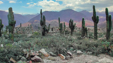
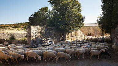
This 302,319 ha property, in the southern part of central France, is a mountain landscape interspersed by deep valleys that is representative of the relationship between agro-pastoral systems and their biophysical environment, notably through drailles or drove roads. Villages and substantial stone farmhouses on deep terraces of the Causses reflect the organization of large abbeys from the 11th century. Mont Lozère, inside the property, is one of the last places where summer transhumance is still practiced in the traditional way, using the drailles.
Description is available under license CC-BY-SA IGO 3.0
Les Causses et les Cévennes, paysage culturel de l’agro-pastoralisme méditerranéen
Le site, s'étendant sur 302 319 ha au sud du Massif central français, constitue un paysage de montagnes tressées de profondes vallées qui est représentatif de la relation existant entre les systèmes agropastoraux et leur environnement biophysique, notamment au travers des drailles ou routes de transhumance. Les villages et les grandes fermes en pierre situées sur les terrasses profondes des Causses reflètent l'organisation des grandes abbayes à partir du XIe siècle. Le mont Lozère, faisant partie du site, est l'un des derniers lieux où l'on pratique toujours la transhumance estivale de la manière traditionnelle, en utilisant les drailles.
Description is available under license CC-BY-SA IGO 3.0
الكاوس والسيفين
المشهد المتوسطي الثقافي والزراعي : يمتد هذا الموقع على مسافة 302.319 هكتارا، في الجانب الجنوبي من وسط فرنسا. يشكل مجموعة من المرتفعات الجبلية تتخللها وديان عميقة وهي تمثل العلاقة بين نمط العيش من الزراعة والماشية والمحيط الحيوي والفيزيائي، لاسيما عبر الدروب الجبلية أو طرق السيارات. القرى والمزارع المبنية من الحجر المصقول فوق المدرجات الزراعية تعكس في منطقة الكاوس طريقة التنظيم للأديرة الكثيرة منذ القرن الحادي عشر. وجبل لوزير في هذا الموقع لا يزال حتى اليوم مقصدا ومرعى للماشية في موسم الصيف.
source: UNESCO/CPE
Description is available under license CC-BY-SA IGO 3.0
喀斯和塞文--地中海农牧文化景观
占地302319公顷,位于法国中南部山脉与深谷交错的地区,农牧系统与自然环境之间的纽带在这一地区得到了展现,特别是在这一地区夏季上山放牧时,羊群走的山路更是这一纽带的直接反映。景区内的村庄以及喀斯梯田上的坚固的石头农舍体现了11世纪大修道院组织形式。洛泽尔山也位于景观区内,是最后几个还在实行夏季游牧的地区之一。
source: UNESCO/CPE
Description is available under license CC-BY-SA IGO 3.0
Коcы и Севены, средиземноморский агро-пастбищный культурный ландшафт
Территория площадью в 302,319 га, расположенная в южной части центральной Европы, представляет горный ландшафт, рассечённый глубокими долинами, В них видна связь между агро-пастбищными системами и естественной биофизической средой, примером могут служить тропы для перегона стад. Деревни и добротные сельские каменные жилые дома, построенные на низинных террасах, отражают организацию больших аббатств начиная с 11-го века. В глубине территории находится Мон Лозер, одно из последних мест, где до сих пор практикуется сезонный перегон скота на новые пастбища.
source: UNESCO/CPE
Description is available under license CC-BY-SA IGO 3.0
Paisaje cultural agropastoral mediterráneo de Causses y Cévennes
Se trata de un paisaje montañoso situado en el sur de Francia con valles profundos que es representativo de la relación entre los sistemas agropastorales y su medio ambiente biofísico, en particular a través de cañadas. Los pueblos y las importantes granjas de piedra existentes en las profundas terrazas de las mesetas calcáreas de las Causses reflejan la organización de las abadías desde el siglo XI. Mont Lozère, situado dentro del sitio inscrito, es uno de los últimos lugares donde todavía se practica la transhumancia estival.
source: UNESCO/CPE
Description is available under license CC-BY-SA IGO 3.0
コースとセヴェンヌの地中海性農牧地の文化的景観
中央フランスの南方に、302,319haの広さを有するこの遺産は、深い渓谷が点在する変化に富む山岳景観で、農業・牧畜システムと生物物理学的環境との関連性を示している。 コース地方の村々や、深い段丘の上にある頑丈な石造りの農家からは、11世紀の大きな修道院組織の影響がうかがえる。構成資産のひとつであるモン・ロゼーレは、今でも夏季に伝統的な方法による移動放牧が行われている最後に残る場所のひとつである。source: NFUAJ
Causses en Cévennes, mediterraan cultureel landbouw- en weidelandschap
De hooggelegen landschappen van de Causses zijn meer dan drie millennia gevormd door agro-veeteelt. Ze omvatten 302.319 hectare en liggen in het zuidelijke deel van Midden-Frankrijk. Het is een berglandschap afgewisseld door diepe valleien, representatief voor de relatie tussen agro-pastorale systemen en hun biofysische omgeving, gekenmerkt door drailles of veepaden. De dorpen en stevige stenen boerderijen op de diepe terrassen van de Causses (kalkplateaus) weerspiegelen de organisatie van grote abdijen sinds de 11e eeuw. Binnen dit gebied ligt Mont Lozère, een van de laatste plaatsen waar ’s zomers de transhumance (verplaatsing van schapen) over de drailles nog steeds op de traditionele manier wordt uitgevoerd.
Source: unesco.nl

Outstanding Universal Value
Brief synthesis
The upland landscapes of the Causses have been shaped by agro-pastoralism over three millennia. In the Middle Ages, the development of cities in the surrounding Mediterranean plains, and especially the growth of religious institutions, prompted the evolution of a land structure based on agro-pastoralism, the basis of which is still in place today. Too poor to host cities, too rich to be abandoned, the landscape of Causses and Cévennes are the result of the modification of the natural environment by agro-pastoral systems over a millennium. The Causses and Cévennes demonstrate almost every type of pastoral organisation to be found around the Mediterranean (agro-pastoralism, silvi-pastoralism, transhumance and sedentary pastoralism). The area has by a remarkable vitality as a result of active renewal of the agri-pastoral systems. This area is a major and viable example of Mediterranean agro-pastoralism. Its preservation is necessary to deal with threats from environmental, economic and social issues that such cultural landscapes are facing globally. The Causses and the Cévennes retain numerous testimonies of the evolution over several centuries of its pastoral societies. Their important built heritage, landscape characteristics and intangible associations that reflect traditional pastoralism will be sustained by a contemporary revival of agro-pastoralism.
Criterion (iii): The Causses and the Cévennes, manifest an outstanding example of one type of Mediterranean agro-pastoralism. This cultural tradition, based on distinctive socialstructures and local breeds of sheep, is reflected in the structure of the landscape, especially the patterns of farms, settlements, fields, water management, drailles and open grazed common land and what it reveals of the way this has evolved, in particular since the 12th century.The agro-pastoral tradition is still living and has been revitalisedin recent decades.
Criterion (v): The Causses and the Cévennes can be seen as an exemplar of Mediterranean agropastoralism and specifically to represent a response common to the south-west of Europe. The landscape areas manifest exceptional responses to the way the system has developed over time and particularly over the past millennia.
Integrity
The wholeness or intactness of the cultural landscape is related to the survival of the forces that shaped the landscape as well as to the symptoms that those forces produced. The aim is to maintain these through the perpetuation of traditional activities and the support of those activities through Park staff and external grants. In many places the landscape is almost relict -particularly the terraces in the Cévennes, where only a fraction are actively managed. In some place, the systems of transhumance along drove roads barely survives - only a few flocks make the long journeys each year and many of the tracks are beginning to be covered with scrub. However there is now increasing attention being paid to supporting and reviving these processes. The water systems that once were the lifeblood of the fields and bergeries are now only maintained in places.
Authenticity
The key structures of the landscape: buildings, terraces, walls and watercourses retain a high degree of authenticity in terms of their built fabric, but many particularly the terraces need conservation. Less of these are now within the nominated area of the Cévennes. As for the authenticity of the agro-pastoral processes that shaped the landscape, these processes are surviving, and although vulnerable and in the hands of very fewfarmers (no more than 100), they are subject to a renaissance thanks to the combined action of local and national authorities and local communities.
Protection and management requirements
The whole of the areas is protected either for natural or cultural heritage but only the core of the Cévennes National Park is protected for both. The totality of the nominated area is protected in a variety of different forms, but only part is protected for cultural attributes. The Parc national des Cévennes (PNC), with its headquarters at Florac, is a public national administrative body (établissement public national à caractère administratif) created in September 1970 under the provisions of the Law of 22 July 1960. There are 117 communes within its 321,380ha. It has been a biosphere reserve as part of the UNESCO Man and the Biosphere programme since 1985. In the core area of the park, cultural property is protected and no new building is allowed. The Parc naturel régional des Grands Causses (PNR) was founded in 1995 under the provisions of the Law of 5 July 1972 which established the category of Regional Natural Parks. At 315,949ha and covering 94 communes it is almost as large as the PNC. Its status and powers are broadly comparable with those of a national park. Its policies are determined by a Syndicat de collectivités, a public body which brings together communes and other entities with the objective of carrying out works and providing services for the communities involved. The Centre permanent d'initiatives pour l'Environnement des Causses méridionaux (CPIE), set up in accordance with 1901 legislation and representing 28 communes in the Départements of Gard and Hérault, is a body which enables these collectives to prepare and implement policies and activities of common interest. The Gorges du Tarn and de la Jonte, which extend over some 29,000ha, were classified as protected sites on 29 March 2002, as a result of which any proposed changes in their condition or character must be approved by the relevant Minister or by the Prefect of Aveyron. In addition, a large number of historic buildings and architectural ensembles are protected under the provisions of the 1913 historic monuments legislation. A number of architectural groups and small villages are designated as Zones de protection du patrimoine architectural, urbain et paysager (ZPPAUP). There is a need for tighter protection for the overall landscape to protect cultural attributes in response to identified threats and a range of complementary measures to coordinate and strengthen existing protection will be put in place by 2015.
The property has a Management Plan supported by the key stakeholders. There is huge involvement and support of the local farming communities in sustaining the agro-pastoral landscape. A Strategy for 2007-2013 addresses key themes related to improving and sharing knowledge, promoting an understanding of the living landscape and encouraging the participation of all the key players. The Strategy includes completing an atlas of the landscape, drawing up an inventory of attributes of the landscape; developing knowledge of the landscape; acquiring a common language for the landscape; developing a decision-making tool for the restoration and the management of the landscapes; and identifying emblematic sites of the cultural landscape. Implementation of the Strategy is urgently needed to underpin the whole rationale for identification, protection and management of the agro-pastoral landscape.


Protections
by other conservation instruments
2 protections / 3 elements
2003 Convention for the Safeguarding of the Intangible Cultural Heritage (2 elements)Biosphere Reserves (1 element)