Koutammakou, the Land of the Batammariba
Koutammakou, the Land of the Batammariba
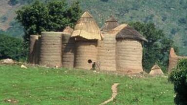
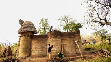
The Koutammakou landscape in north-eastern Togo and neighbouring Benin is home to the Batammariba, whose remarkable mud tower-houses are known as takienta (sikien in the plural). Nature is strongly associated with the rituals and beliefs of society here. The landscape is exceptional due to the architecture of the tower-houses which reflect the social structure; its farmland and forest; and the associations between people and landscape. The buildings are grouped in villages, which also include ceremonial spaces, springs, sacred rocks and sites reserved for initiation ceremonies.
Description is available under license CC-BY-SA IGO 3.0
Koutammakou, le pays des Batammariba
Le paysage du Koutammakou, dans le nord-est du Togo et le Bénin voisin, abrite les Batammariba, dont les remarquables maisons-tours en terre sont connues sous le nom de takienta (sikien au pluriel). Ici, la nature est fortement associée aux rituels et aux croyances de la société. Le paysage est exceptionnel en raison de l'architecture des maisons-tours qui reflètent la structure sociale, de ses terres agricoles et de ses forêts, et des associations entre les gens et le paysage. Les bâtiments sont regroupés en villages, qui comprennent également des espaces cérémoniels, des sources, des rochers sacrés et des sites réservés aux cérémonies d'initiation.
Description is available under license CC-BY-SA IGO 3.0
كوتاماكو، وطن باتاماريبا [توسيع موقع
source: UNESCO/CPE
Description is available under license CC-BY-SA IGO 3.0
古帕玛库,巴塔马利巴人之地
source: UNESCO/CPE
Description is available under license CC-BY-SA IGO 3.0
земля народности батаммариба
source: UNESCO/CPE
Description is available under license CC-BY-SA IGO 3.0
Kutammaku, el país de los Batammariba
source: UNESCO/CPE
Description is available under license CC-BY-SA IGO 3.0

Outstanding Universal Value
Brief synthesis
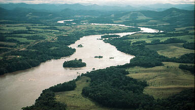
Koutammakou is the name of a large territory in north-western Benin and north-eastern Togo. Dominated for the most part by the Atacora Mountains, this living cultural landscape is inhabited by the Batammariba, a people whose remarkable mud tower-houses known as sikien (takienta in the singular) have become a symbol of Togo and Benin. It forms a coherent cultural continuum, with the Beninese part home to the historical birthplace of the Batammariba.
Koutammakou is an eminent example of the occupation of land by a people in constant search of harmony between humans and their natural environment. The Koutammakou cultural landscape has a wholly distinctive character. The takienta, the basic family dwelling which serves a technical, utilitarian and symbolic purpose, is truly one-of-a-kind. While many of the habitats in the region have fairly strong symbolic dimensions, no others demonstrate such a close interrelationship between symbolism, function and technique. This particular type of habitat, whose style is based on circular or elliptical shapes, is the ingenious brainchild of the Batammariba, which means "Those who shape the earth" in Ditammari (the language of the Otammari people).
Koutammakou is a continuing living landscape representing the features of a farming society working in harmony with the landscape, where nature underpins beliefs, rituals and daily life. It comprises such tangible elements as caves, springs and sacred places, ritual and funerary spaces, groves, sikien, fields, terraced hills, networks of low water-retaining walls, wild and domestic animals (only small game remains in Koutammakou today), as well as intangible elements including beliefs, craft skills, songs, dances and traditional sports.
Criterion (v): Koutammakou is an outstanding example of a traditional settlement system that is still going strong to this day, is subject to traditional and sustainable systems and practices, and reflects the unique culture of the Batammariba, particularly the mud tower-houses known as sikien (takienta in the singular).
Criterion (vi): Koutammakou is an eloquent testimony to the strength of the spiritual association between people and landscape, as manifested in the harmony between the Batammariba and the surrounding natural resources.
Integrity
The Koutammakou cultural landscape as a whole reflects every aspect of Batammariba life, and therefore the socio-economic and cultural system that exists within the property. The Beninese part reinforces the historical integrity of Koutammakou by including the historical birthplace of the Batammariba (before their dispersal), occupied since the 6th century. The religious centres of Koubonku and Koubentiégou remain sacred places for the Batammariba, who continue to celebrate major worship ceremonies and initiation festivals there.
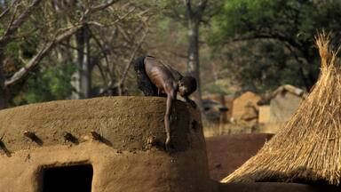
Traditional housing is still a model today. Throughout the region, it is evident that the life cycle of buildings goes on: construction, abandonment, destruction and rebuilding on the ruins. While close observation shows that there have been changes in the materials used, the traditional model persists, because the takienta is more than a dwelling: it is a temple dedicated to the worship of ancestors. As such, even the space on the ground floor reserved for animals and the presence of granaries on the terrace remain essential elements. For example, many so-called "modern" houses (rectangular dwellings with tin roofs) are complemented by traditional dwellings which, though sometimes smaller in scale, nonetheless retain all their traditional architectural features and the intangible dimensions of the worship practices, beliefs and rituals associated with these buildings. Right across Koutammakou, several thousand sikien have thus been identified, including 1,400 still inhabited in Benin and 1,716 in Togo.
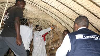
Maintaining the sikien (mud tower-houses) requires the perpetuation of local building traditions and the use of local materials. The natural environment has suffered from some over-exploitation and it is becoming increasingly difficult to find enough wood and straw for new houses close to the villages. The integrity of the intangible aspects is in an excellent state of conservation: the link between attributes and symbolism - sacred woods, ritual paths, and the conservation of traditions and ways of life, which is reflected in the construction of the sikien.
Authenticity
The cultural landscape of Koutammakou reflects a particular way of life and processes and practices that have endured for centuries. To preserve its authenticity, maintaining these traditional practices is essential.
Education, the centralization of administrative power, religions, tourism, monetarization and the emergence of new needs are all wielding an influence. Despite these changes, which are tending to disrupt Tammari society, there are still very strong traditional nuclei in all the villages that form this melting pot, where the unique culture of the Batammariba is perpetuated through time and space. Cultural expressions persist in spite of the upheavals caused by globalization. Respect for the spirits of the ancestors and the rites of passage for boys (difoini) and girls (dikuntri) endure with as much interest for the local populations as for the diaspora. As such, although semi-urban centres have developed (Nadoba, Warengo, Koutougou in Togo, Natta, Natitingou and Boukombé in Benin), the cultural landscape that can be seen today is unchanged, with villages of sikien surrounded by modern, detached houses which are well spaced out and set in the middle of their arable plot of land.
The environment continues to be preserved for ritual (groves) and medicinal (plants) purposes as well as for the materials needed to build the sikien. Measures will be needed, however, to replant certain plant species used in traditional architecture and to demarcate areas closed to grazing. Whilst the younger generations in semi-urban centres are losing interest in this form of architecture, the guardians of the tradition continue to uphold and pass on the knowledge and skills associated with the sikien building culture. In addition, the Batammariba meet every year for a big festival organized alternately in Benin (FACTAM) and Togo (FESTAMBER). In Benin and Togo, projects are encouraging community involvement in the conservation, enhancement and promotion of Tammari culture.
Protection and management requirements
The Koutammakou region benefits from two types of protection: modern legal protection and traditional protection. Among the full legal apparatus, the Togolese part is protected by Law 90-24 of 23 November 1990 on the protection of national cultural heritage, Order No. 010/MCJS of 17 July 2003 on the inclusion of sites and monuments on the national heritage list of cultural properties, Order No. 124/MC/CAB of 1 October 2003 setting the geographical limits of the site and determining the components of Koutammakou, Decree No. 2010-173/PR of 15 December 2021 on the National Commission for Cultural Heritage in Togo, Law No. 2018-011 of 31 January 2018 amending Law No. 2007-011 of 13 March 2007 on decentralization and local freedoms, the Order on the composition and powers of the Koutammakou management committee, and Order No. 015/MCCSFC/CAB/18 of 17 May 2018 creating the Koutammakou conservation and promotion department.
The Benin part is protected by Interministerial Decree 2020 No. 71/MTCA/MCVDD/MEF/DC/SGM/CTJ/CTC/DPC/ CCJ/SA058SGG20 fixing its geographical limits and determining its components in Benin, Law No. 91-006 of 25 February 1991 on the Cultural Charter in the Republic of Benin, Law No. 2007-20 of 23 August 2007 on the protection of cultural heritage and natural heritage of a cultural nature in the Republic of Benin and Decree No. 2019-521 of 27 November 2019 on the powers, organization and functioning of the Ministry of Tourism, Culture and the Arts. To guarantee the property’s preservation amid the urbanization of urban centres, steps are also being taken in Togo to draw up the local urbanization plan (PUL), and in Benin to draft the municipal development master plans for Boukombé, Toucountouna and Natitingou.
Although the effects of changing lifestyles and the impact of climate change are now being felt in traditional Batammariba society, there are still many guardians of tradition who keep the rituals and beliefs of the Tammari people alive. Traditional practices, which cover not only technical processes but also social observances with repercussions on land management, include: respect for ancestors; observance of taboos and restrictions; absolute obedience to elders, religious leaders and clan chiefs; perpetuation of traditional rules, reaffirmed through initiation ceremonies; carefully prescribed roles for each clan member; and continuing respect for the tangible and intangible values associated with the landscape.
These objectives are fully in line with the Koutammakou management plans of Togo and Benin, which are managed respectively by two separate departments for the conservation and promotion of Koutammakou. The ultimate aim is to set up a transnational management body for the property, under the supervision of the two cultural heritage directorates in Togo and Benin, with definition of the operating procedures and remit of this body. The management plan (2021-2025) for the Beninese part has therefore been drawn up in line with the guiding principles and guidelines of the management plan for the Togolese part, finalized in 2021 to cover the period 2022-2024. The purpose of the latter is to shore up or complement traditional protection in order to guarantee the proper conservation of the site and the intangible elements that underpin it. The objectives are to encourage the use of traditional materials for the construction of sikien to preserve the authenticity and integrity of the site, control the unmanaged exploitation of wood in fallow areas, achieve sustainable development within a living cultural landscape, showcase Tammari culture and promote a form of tourism that respects the values of the site. However, several key aspects will require further action for the Beninese part, such as the definition of clear protection and conservation priorities for areas with high concentrations of attributes, or greater involvement of the Batammariba in the management of the property and consideration of the traditional management and conservation practices of Koutammakou.


The Nomination files produced by the States Parties are published by the World Heritage Centre at its website and/or in working documents in order to ensure transparency, access to information and to facilitate the preparations of comparative analysis by other nominating States Parties.
The sole responsibility for the content of each Nomination file lies with the State Party concerned. The publication of the Nomination file, including the maps and names, does not imply the expression of any opinion whatsoever of the World Heritage Committee or of the Secretariat of UNESCO concerning the history or legal status of any country, territory, city or area or of its boundaries.