With 13,720 km², the Okapi Wildlife Reserve has rich biodiversity and a forest ecosystem with cultural and economic importance for the traditional nomadic pygmy hunters Mbuti and Efe who it is believed, have been inhabiting these forests for 40,000 years.
Although, the reserve is strongly protected, it has faced, in particular along its western boundary, rapidly escalating threats caused by insecurity, poaching and illegal wildlife trafficking that are aggravated by an illegal mining economy involving armed groups and clandestine actors.
The Okapi Wildlife Reserve was inscribed on the World Heritage list in 1996 and the World Heritage List in Danger since 1997.
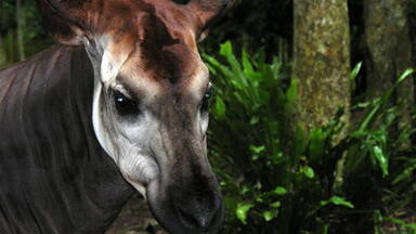
Located in the northeast of the DRC, the Okapi Wildlife Reserve occupies about one-fifth of the Ituri forest in the north-east of the Democratic Republic of the Congo. The Congo river basin, of which the reserve and forest are a part, is one of the largest drainage systems in Africa. The reserve contains threatened species of primates and birds and about one-sixth of the okapi populations living in the wild. The okapi is endemic to the DRC and is a species protected by national laws.
Objectives
In line with Decision 43 COM 7A.9 adopted by the World Heritage Committee at its 43rd session (Baku, 2019), the main outputs of this project are as follows:
Resolve conflicts related to the use of natural resources
Facilitate the demarcation of the western boundaries of the property to resolve conflicts related to the use of natural resources;
Empowerment of communities
Improve the efficiency of the management of the property by contributing to the empowerment of communities and ensuring their involvement in management and development activities.
Achievements
- Mapping of semi-industrial and small-scale artisanal illegal mining and associated activities in the western portion of the property.
- Collection of spatial information on boundary locations and the presence of concessions inside the property.
- Support towards establishing a joint commission including the Congolese Institute for Nature Conservation (ICCN), the Mining Cadastre (CAMI), and third parties from the National Cartographic Institute (IGC) and the Ministry of Mines, among others, to harmonize maps for the property and resolve the issue of overlapping mining permits in the western part of the property.
Sustainable development goals (SDGs) addressed by the project: 11.4 and 15.1
Partners
Wildlife Conservation Society (WCS) and Institut Congolais pour la Conservation de la Nature (ICCN)
This project is made possible thanks to the financial support of the Norwegian government.
Decisions / Resolutions (1)
The World Heritage Committee,
- Having examined Document WHC/19/43.COM/7A.Add,
- Recalling Decisions 41 COM 7A.9 and 42 COM 7A.49, adopted at its 41st (Krakow, 2017) and 42nd (Manama, 2018) sessions respectively,
- Reiterates its concern for the continued insecurity, which limits surveillance coverage of the property, and reiterates its request to the State Party to rapidly strengthen the number and capacity of guards, as well as the budget for the property in order to extend the coverage of the patrols and progressively gain full control of the property and drastically reduce the poaching that affects the Outstanding Universal Value (OUV);
- Welcomes the improved cooperation with the armed forces, allowing more joint patrols to secure the property and resulting in the military evacuating its positions in the property, including the mining quarries;
- Appreciates the actions taken to close some artisanal mines and urges again the State Party to undertake urgent measures to close all illegal artisanal mines within the property and ensure their rehabilitation;
- Also reiterates its request to the State Party to update the data concerning the number of residents in the property and the villages located along the National Road (RN4) to assess the impacts of the increase in populations on the land-use in the property;
- Notes the delay in updating the Integrated Management Plan (PAG) for the property and the validation of the Central Integral Conservation Zone, and also urges the State Party to expedite the updating of the PAG, integrating provisions relating to the different zones of the property, including the subsistence zones, the Central Integral Conservation Zone and forestry concessions for local communities, and ensure its immediate implementation;
- Further reiterates its request to the State Party to provide the Spatial Monitoring and Reporting Tool (SMART) data collected to enable an assessment of the illegal activities on the OUV of the property and data concerning progress accomplished with regard to the indicators defined in the Desired state of conservation for the removal of the property from the List of World Heritage in Danger (DSOCR);
- Requests the State Party to submit to the World Heritage Centre, by 1 February 2020, an updated report on the state of conservation of the property and the implementation of the above, for examination by the World Heritage Committee at its 44th session in 2020;
- Decides to continue to apply the Reinforced Monitoring Mechanism for the property;
- Also decides to retain Okapi Wildlife Reserve (Democratic Republic of the Congo) on the List of World Heritage in Danger.

