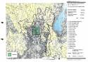
Historic Monuments of Ancient Kyoto (Kyoto, Uji and Otsu Cities)
Multiple Locations (17)
| ID | Name & Location | State Party | Coordinates | Property | Buffer Zone |
|---|---|---|---|---|---|
| 688-001 | Kamowakeikazuchi-jinja (Kamigamo shrine) | Japan |
N35 3 37.9 E135 45 11.6 |
63.8 ha | 242.7 ha |
| 688-002 | Kamomioya-jinja (Shimogamo Shrine) | Japan |
N35 2 19.54 E135 46 24.75 |
10.7 ha | 105.3 ha |
| 688-003 | Kyo-o-gokoku-ji (To-ji) | Japan |
N34 58 50.58 E135 44 52.1 |
8.5 ha | 22.8 ha |
| 688-004 | Kiyomizu-dera | Japan |
N34 59 41.37 E135 47 5.75 |
12.3 ha | 161.1 ha |
| 688-005 | Enryaku-ji | Japan |
N35 4 14.46 E135 50 29.02 |
497.7 ha | 1,005 ha |
| 688-006 | Daigo-ji | Japan |
N34 57 3.04 E135 49 10.41 |
378.7 ha | 218.7 ha |
| 688-007 | Ninna-ji | Japan |
N35 1 52.44 E135 42 50.87 |
9.2 ha | 431.3 ha |
| 688-008 | Byodo-in | Japan |
N34 53 22.02 E135 48 27.6 |
2 ha | 203.8 ha |
| 688-009 | Ujigami-jinja | Japan |
N34 53 31.19 E135 48 42.32 |
0.3 ha | — |
| 688-010 | Kozan-ji | Japan |
N35 3 37.46 E135 40 43.85 |
15.7 ha | 444.9 ha |
| 688-011 | Saiho-ji | Japan |
N34 59 32.28 E135 41 1.63 |
1.7 ha | 204.6 ha |
| 688-012 | Tenryu-ji | Japan |
N35 1 0.06 E135 40 28.97 |
3 ha | 167 ha |
| 688-013 | Rokuon-ji | Japan |
N35 2 22.24 E135 43 46.2 |
9.3 ha | — |
| 688-014 | Jisho-ji | Japan |
N35 1 38.07 E135 47 54.78 |
5.7 ha | 318.9 ha |
| 688-015 | Ryoan-ji | Japan |
N35 2 4.69 E135 43 7.64 |
3.9 ha | — |
| 688-016 | Hongan-ji | Japan |
N34 59 28.17 E135 45 4.06 |
6.1 ha | 24.3 ha |
| 688-017 | Nijo-jo | Japan |
N35 0 50.88 E135 44 54.72 |
27.5 ha | 28.7 ha |

Disclaimer
The Nomination files produced by the States Parties are published by the World Heritage Centre at its website and/or in working documents in order to ensure transparency, access to information and to facilitate the preparations of comparative analysis by other nominating States Parties.
The sole responsibility for the content of each Nomination file lies with the State Party concerned. The publication of the Nomination file does not imply the expression of any opinion whatsoever of the World Heritage Committee or of the Secretariat of UNESCO concerning the history or legal status of any country, territory, city or area or of its boundaries.