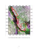
Samarra Archaeological City
Multiple Locations (10)
| ID | Name & Location | State Party | Coordinates | Property | Buffer Zone |
|---|---|---|---|---|---|
| 276rev-001 | Samarra North Zone - al-Mutawakkiliyya | Iraq |
N34 20 27.56 E43 49 24.76 |
4,478 ha | 31,414 ha |
| 276rev-002 | Samarra Centre Zone | Iraq |
N34 13 34.59 E43 52 57.26 |
1,265 ha | |
| 276rev-003 | Samarra South Zone | Iraq |
N34 7 21.42 E43 55 50.23 |
8,953 ha | |
| 276rev-004 | al-Istablat | Iraq |
N34 4 49.04 E43 54 56.12 |
155 ha | |
| 276rev-005 | al-Quwayr | Iraq |
N34 13 55.63 E43 50 23.53 |
11 ha | |
| 276rev-006 | Qubbat al-Sulaibiyya | Iraq |
N34 13 39.54 E43 47 56.09 |
0.6 ha | |
| 276rev-007 | al-Ma'shuq | Iraq |
N34 14 31.14 E43 48 34.02 |
20 ha | |
| 276rev-008 | Tell Umm al-Sakhr | Iraq |
N34 15 59.82 E43 48 6.33 |
2 ha | |
| 276rev-009 | al-Huwaysilat Upper | Iraq |
N34 17 40.06 E43 47 19.81 |
5 ha | |
| 276rev-010 | al-Huwaysilat Lower | Iraq |
N34 17 56.90 E43 47 21.64 |
4 ha |
Maps
Disclaimer
The Nomination files produced by the States Parties are published by the World Heritage Centre at its website and/or in working documents in order to ensure transparency, access to information and to facilitate the preparations of comparative analysis by other nominating States Parties.
The sole responsibility for the content of each Nomination file lies with the State Party concerned. The publication of the Nomination file, including the maps and names, does not imply the expression of any opinion whatsoever of the World Heritage Committee or of the Secretariat of UNESCO concerning the history or legal status of any country, territory, city or area or of its boundaries.