The par force hunting landscape in North Zealand
The par force hunting landscape in North Zealand
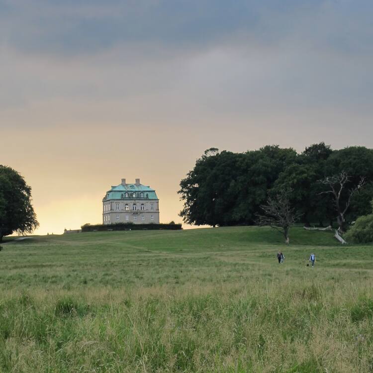
Located about 30 km northeast of Copenhagen, this cultural landscape encompasses the two hunting forests of Store Dyrehave and Gribskov, as well as the hunting park of Jægersborg Hegn/Jægersborg Dyrehave. This is a designed landscape where Danish kings and their court practiced par force hunting, or hunting with hounds, which reached its peak between the 17th and the late 18th centuries, when the absloute monarchs transformed it into a landscape of power. With hunting lanes laid out in a star system, combined with an orthogonal grid pattern, numbered stone posts, fences and a hunting lodge, the site demonstrates the application of Baroque landscaping principles to forested areas.
Description is available under license CC-BY-SA IGO 3.0
Paysage de chasse à courre de Zélande du Nord
A quelques 30 kilomètres au nord-est de Copenhague, ce paysage de chasse comprend trois forêts et paysages distincts : Store Dyrehave, Gribskov et Jægersborg Hegn/Jægersborg Dyrehave. Il s’agit d’un paysage aménagé où les rois danois et leur cour se livraient à la chasse « par force », ou chasse à courre, qui atteignit son point culminant entre le XVIIe et la fin du XVIIIe siècle, lorsque les rois absolus l'ont transformé en un paysage de puissance. Avec les chemins organisés en système d’étoile, combinés avec une grille orthogonale, des pierres numérotées, des clôtures et un pavillon de chasse, ces sites matérialisent l’application des principes d’aménagement paysager baroque à des zones forestières.
Description is available under license CC-BY-SA IGO 3.0
موقع الصيد بالمطاردة في جوتلاند الشمالية
يضم موقع الصيد هذا، الذي يقع على مسافة تناهز 30 كيلومتراً شمال شرق كوبنهاغن، ثلاث غابات ومساحات منفصلة هي ستور ديريهايف وغريبسكوف وييرسبورغ هاين/ييرسبورغ ديريهايف. والموقع عبارة عن منطقة منظّمة كان الملوك الدنماركيون وحاشياتهم يقصدونها لممارسة هواية الصيد بالمطاردة التي بلغت ذروتها في الفترة الممتدة من العصور الوسطى إلى نهاية القرن السادس عشر. ويبرِز الموقع، بممراته المرتبة حسب شبكة متعامدة، وكتل الحجارة المرقمة التي تحدد تخومه، وأسياجه، وما يتخلله من أرواق للصيد، الطريقة التي طبِّقت بها مبادئ تنظيم المساحات في فن العمارة الباروكي على الغابات.
source: UNESCO/CPE
Description is available under license CC-BY-SA IGO 3.0
北西兰岛狩猎园林
这片园林位于哥本哈根市北部30公里处,包含三处独特的森林景区:斯托尔·鹿之园,格里布斯科夫,斯克斯堡栅栏和斯克斯堡鹿之园。这里曾是丹麦王室“武力”狩猎:或利用猎犬围猎的地方,在中世纪到十六世纪末达到巅峰。这里道路成网格状排列,编号石板,栅栏与狩猎小屋无不呈现了巴洛克式园林规划风格在森林地带的应用。
source: UNESCO/CPE
Description is available under license CC-BY-SA IGO 3.0
Охотничьи угодья Северной Зеландии
Охотничьи угодья Северной Зеландии, расположенные примерно в 30 км к северо-востоку от Копенгагена, включают в себя два лесных массива Store Dyrehave (что в переводе означает «Большой сад животных») и Gribskov и лесопарковую зону Jægersborg Hegn/Jægersborg Dyrehave. Объект представляет собой ухоженную территорию, где короли Дании и их придворные занимались парфорсной (par force) псовой охотой, пик этого увлечения пришелся на период с конца Средневековья по конец XVI века. Охотничьи просеки, расположенные в форме прямоугольной сети, пронумерованные каменные межевые столбы, ограждения и охотничьи домики отражают применение основных принципов ландшафтного дизайна в стиле барокко в планировании лесопарковых зон.
source: UNESCO/CPE
Description is available under license CC-BY-SA IGO 3.0
Paisaje cinegético de montería de Selandia Septentrional
Situado a unos 30 kilómetros al nordeste de Copenhague, este bien cultural comprende tres zonas diferenciadas de bosques para monterías: Store Dyrehave, Gribskov y Jægersborg Hegn/Jægersborg Dyrehave. En esos bosques acondicionados para la caza de montería, los reyes daneses y sus cortesanos practicaban esta modalidad cinegética que estuvo en pleno apogeo desde la Edad Media hasta finales del siglo XVI. Los caminos trazados con arreglo a un plano ortogonal, los mojones de piedra numerados, los cercados y los pabellones de caza edificados en esos bosques constituyen una materialización de los principios paisajísticos del Barroco aplicados al acondicionamiento de zonas forestales.
source: UNESCO/CPE
Description is available under license CC-BY-SA IGO 3.0
シェラン島北部のパル・フォルス狩猟景観
首都コペンハーゲンを擁するシェラン島北部にある、旧王室の狩猟用の2つの森と、森をつなぐ道の跡、旧王室の狩猟場だった「鹿公園」を含む狩猟景観。森では主に、騎乗して猟犬を伴う「パル・フォルス式」の狩猟が行われていた。番号が振られた石標や石柱、柵、狩猟小屋などのデザインはバロック様式。これは、ヨーロッパにおけるバロック様式の流行が、17~18世紀の造園の発展に影響を与えたことを示すとともに、ヨーロッパの景観デザインが狩猟場に適用された重要な段階を示している。source: NFUAJ
Parforce-jachtlandschap in Noord-Zeeland
Dit culturele landschap, gelegen op ongeveer 30 km ten noordoosten van Kopenhagen, omvat de twee jachtbossen van Store Dyrehave en Gribskov, evenals het jachtpark van Jægersborg Hegn / Jægersborg Dyrehave. Dit is een ontworpen landschap waar de Deense koningen en hun hof de parforce-jacht, of jacht met honden, uitoefenden. Deze jachtvorm bereikte zijn hoogtepunt van de middeleeuwen tot het einde van de 16e eeuw. Met jachtpaden die zijn gelegd in een orthogonaal rasterpatroon, hun genummerde stenen aanduidingen, de behuizingen en jachthutten, toont de site de toepassing van barokke landschapsarchitectuurprincipes op beboste gebieden.
Source: unesco.nl
Outstanding Universal Value
Brief synthesis
The par force hunting landscape in North Zealand series covers the former royal hunting forests of Store Dyrehave and Gribskov, traces of connecting roads between them, and the former royal hunting park of Jægersborg Dyrehave/Jægersborg Hegn. The entire former royal forest landscape covered a much larger area with a number of royal castles. The components have been selected as they encompass a completeness of attributes illustrating the development of the Baroque par force hunting landscape as an emblematic and functional spatial entity. Designed and created intentionally by Man, the par force hunting landscape exemplifies a 17th-18th-century landscape created to perform courtly hunts. Its layout results from the combination of French and German design models based on a central-star grid system, combined with an orthogonal grid subdivision, which optimised its function during the hunt, and makes it emblematic of an absolute European monarch, his role in society, and his reason and power to control nature. The Outstanding Universal Value of the landscape lies in the spatial organisation of the hunting forests, hunting roads, buildings, emblematic markers, numbered stone posts, stone fences, and numerical road names conveying an understanding of the practical application of the design as a means of orientation.
Criterion (ii): The par force hunting landscape in North Zealand exceptionally exemplifies how the interchange of Baroque values in Europe influenced developments in landscape design in the 17th-18th centuries, and particularly bears witness to the influence exerted by French and German designed hunting landscapes. These models were adapted to the specific situation of the Danish terrain and to the Danish kings’ aspirations. The series illustrates a development in design that evolved alongside the landscape function during par force hunts also in terms of its increasing symbolic significance.
Criterion (iv): As a landscape of power created by an absolute monarch in the late 17th century, the par force hunting landscape in North Zealand exemplifies a significant stage in European landscape design applied to hunting grounds when the rise of scientific thought took place within the context of absolutist ambitions. The orthogonal geometry conceived for its design improved the octagon or circle-based star network used in French or German examples. In its infinite expandability, the orthogonal grid could give equal access to all parts of the forest; differently from radial examples, its diagonals created more than one star point suitable for the rendez-vous.
Integrity
The series comprising the two hunting forests Store Dyrehave and Gribskov, the six partially preserved road traces between them, and the hunting park of Jægersborg Dyrehave and Jægersborg Hegn exhibits all attributes necessary to express the Outstanding Universal Value of the par force hunting landscape in North Zealand. The preserved forest cover, despite interventions of reforestation, the hunting roads and their mutual situation, the numbered stones, the fences and the emblematic markers altogether give a clear understanding of a spatial plan that focused on nature and developed in line with changes in the practical and emblematic demands of the absolute monarch. Visual and functional integrity of some components has suffered from the effects of development; however the property currently does not suffer from development or neglect and urban pressure in the wider setting is under control. The character of the wider setting facilitates the understanding of the property.
Authenticity
The history of North Zealand as a royal estate, later to become state-owned, is thoroughly documented in sources of high credibility. Historical maps confirm that the forest cover and the road systems realised according to the original spatial plan have survived to a large extent. In Store Dyrehave most secondary rides have disappeared, as has the forest cover, which has been changed due to later reforestation, and parts of the roads connecting Gribskov and Store Dyrehave. All original road dams and the stone fence around Store Dyrehave are authentic, while wooden bridges and fences have been replaced several times. Stone posts in Store Dyrehave reflect their original positions. The king's monogram, crown and initials document the authenticity of Kongestenen, but the mound it was placed on has been disturbed. The series gives a clear sense of the spatial development of the par force hunting landscape. The character of the wider setting contributes to the understanding of the series as the best-preserved elements of a wider historic designed hunting landscape.
Protection and management requirements
The property is almost entirely state- or municipality-owned and is protected by national acts and enactments, regional plans and agreements, and municipal and local plans. Almost all activities are determined by the budget. Responsibility for the forest management rests with the Nature Agency. Fifteen-year management plans also stipulate how this protected cultural heritage should be managed. The Agency for Palaces and Cultural Properties manages Eremitageslottet and operates 10-year plans. The municipalities have 4-year municipal plans providing frameworks for local plans and guidelines to protect cultural heritage, including road traces in private ownership. The cooperation and coordination among all institutions and bodies with responsibilities in the property and buffer zones ensures the long-term effectiveness of protection and management and is granted by a Steering Committee representing state agencies, municipalities, and museums. As the public's awareness of the cultural heritage of the area, and their desire to return to it time and again, are vital to the successful long-term protection of the par force hunting landscape of North Zealand, the property is well equipped with public facilities, and the dissemination of knowledge should be based on a comprehensive strategy and focussed on the Outstanding Universal Value.


