Stone Circles of Senegambia
Stone Circles of Senegambia
The site consists of four large groups of stone circles that represent an extraordinary concentration of over 1,000 monuments in a band 100 km wide along some 350 km of the River Gambia. The four groups, Sine Ngayène, Wanar, Wassu and Kerbatch, cover 93 stone circles and numerous tumuli, burial mounds, some of which have been excavated to reveal material that suggest dates between 3rd century BC and 16th century AD. Together the stone circles of laterite pillars and their associated burial mounds present a vast sacred landscape created over more than 1,500 years. It reflects a prosperous, highly organized and lasting society.
Description is available under license CC-BY-SA IGO 3.0
Cercles mégalithiques de Sénégambie
Ces quatre grands groupes de cercles mégalithiques constituent une concentration extraordinaire - plus de 1 000 monuments - sur une bande de 100 km de large qui longe sur 350 km le fleuve Gambie. Les quatre groupes, Sine Ngayène, Wanar, Wassu et Kerbatch rassemblent 93 cercles et de nombreux tumuli, monticules funéraires. Certains ont été fouillés et ont révélé un matériel archéologique que l’on peut dater entre le IIIe siècle av. J.-C et le XVIe siècle de notre ère. Les cercles de pierres de latérite soigneusement taillées et leurs tumuli associés présentent un vaste paysage sacré qui s’est constitué sur plus de 1 500 ans et rendent compte d’une société prospère, pérenne et hautement organisée.
Description is available under license CC-BY-SA IGO 3.0
الدوائر المغليثية المتعلّقة بالآثار السابقة للتاريخ المبنية على الحجارة الضخمة في كونفدرالية السنغال وغامبيا
تشكّل المجموعات الأربعة الكبيرة لهذه الدوائر المغليثية تجمّعاً رائعاً إذ تضمّ أكثر من ألف نُصب تذكاري على رقعة نهر غامبيا بعرض 100 كيلومتر وطول 350 كيلومترا. تضمّ المجموعات الأربع المعروفة بأسماء سين نغايين ووانار وواسو وكرباتش 93 دائرة والعديد من الركام الترابي فوق القبر، والتلال الجنائزية. قد تمّ تنقيب بعضها، فأظهرت مادةً أثرية يمكن تأريخها بين القرن الثالث قبل الميلاد والقرن السادس عشر من حقبتنا هذه. وتشكّل دوائر حجارة الوعنة التي تمّ نحتُها بدقة ورُكامها الترابي منظراً طبيعياً شاسعاً مقدساً تكوّن على مدى أكثر من 1500 عام، وتعكس مجتمعاً مزدهراً مستقرا ومنظماً خير التنظيم.
source: UNESCO/CPE
Description is available under license CC-BY-SA IGO 3.0
塞内冈比亚石圈
在沿冈比亚河350公里长、100公里宽的地带集中了1000多座纪念碑,分成四个巨型石圈组。这四个石圈组包括Sine Ngayène、Wanar、Wassu和Kerbatch,涵盖93个石圈和无数古坟和墓冢,其中一些已经挖掘。出土实物证明,这些遗迹可追溯到公元前3世纪至公元16世纪。红土立柱构成的石圈与周围的墓冢展现了1500多年前盛大而神圣的景象,反映了一个繁荣、组织完备、持久的社会。这些石头是用铁制工具采得,被巧妙地雕琢成了大约七吨重、平均两米高、几乎完全一样的圆柱或多边形立柱。每一个石圈直径4到6米,有8到14根立柱。所有立柱均矗立在墓冢附近。这一杰出遗址代表了该地区更大范围的巨石带,不论是规模、一致性,还是复杂度在全世界都无与伦比。雕琢细致的独立石柱体现了精细、巧妙的雕刻技术,增强了整个石圈群的宏伟气势。
source: UNESCO/CPE
Description is available under license CC-BY-SA IGO 3.0
Кольца камней-мегалитов в Сенегамбии
Объект, составлен четырьмя большими группами колец камней. Четыре группы - Сине-Нгаене, Ваннар, Васса и Кербатч, включают 93 таких кольца, а также значительное число погребальных курганов-тумули, некоторые из которых были раскопаны, чтобы получить материал, позволивший отнести их к периоду от III в. до н.э. до ХVI в. н.э. Кольца латеритовых столбов и связанные с ними погребальные курганы составляют обширный сакральный ландшафт, сложившийся за более чем 1500 лет. Он отражает процветающее, хорошо организованное и длительно существовавшее общество. Камни были добыты с помощью металлических орудий и с тщательностью превращены в почти правильные цилиндрические или многогранные столбы весом в 7 тонн и высотой около 2 метров. Каждое кольцо содержит от 8 до 14 камней и имеет поперечник от 4 до 6 метров. Все они находятся вблизи погребальных курганов. Этот выдающийся объект является лишь частью обширной археологической области, включающей более 1000 мегалитических памятников. Она протягивается полосой на 350 км вдоль реки Гамбия, при ширине 100 км, и по своим размерам, насыщенности и комплексности не имеет аналогов в мире. Прекрасно обработанные столбы, свидетельствующие о высоком мастерстве их создателей, придают особое величие всему ландшафту.
source: UNESCO/CPE
Description is available under license CC-BY-SA IGO 3.0
Círculos Megalíticos de Senegambia
El Sitio está compuesto por los cuatro vastos conjuntos megalíticos de Sine Ngayene, Wanar, Wassu y Kerbatch, que poseen una extraordinaria concentración de más de 1.000 monumentos diseminados en una faja de 100 km de anchura, a lo largo de 350 km del curso del Río Gambia. Los cuatro conjuntos comprenden 93 círculos de piedra y numerosos túmulos funerarios. Algunos de ellos han sido objeto de excavaciones que han permitido encontrar materiales cuya datación se extiende desde el siglo III a.C. hasta el siglo XVI d.C. Los círculos de piedra formados por pilares de laterita trabajados con esmero y los túmulos funerarios conexos componen un vasto paisaje sagrado que se ha ido creando a lo largo de más de 1.500 años. Ese paisaje atestigua la existencia de una sociedad próspera y dotada de un alto grado de organización, que perduró a través de los siglos.
source: UNESCO/CPE
Description is available under license CC-BY-SA IGO 3.0
セネガンビアのストーン・サークル群
アフリカ西部のガンビア川沿いには、長さ約350㎞、幅約100㎞にわたって、ストーン・サークルを中心に1000以上の遺跡が点在する。一つのストーン・サークルは、8~14本の石柱からなり、それぞれの石柱は直径4~6m、高さ平均2mで、鉄器でほぼ完全な円筒形や多角形に削られている。その総数は93に及び、いずれも紀元前3世紀~紀元後16世紀のものとみられ、周辺には多数の塚や墳墓も見つかっている。遺跡群は、大きさ、一貫性、複雑さ、精密さにおいてほか類がなく、高度な組織社会が長年にわたって繁栄してきたことを示すと同時に、この地で行われてきた埋葬習慣を解明する貴重な遺跡となっている。source: NFUAJ
Steencirkels van Senegambia
Dit gebied bestaat uit vier grote groepen van steencirkels die samen een uitzonderlijke verzameling van meer dan 1.000 monumenten vertegenwoordigen. Ze liggen in een strook van 100 kilometer breed langs zo’n 350 kilometer van de Gambia rivier. De groepen – Sine Ngayène, Wanar, Wassu en Kerbatch – omvatten 93 steencirkels en talrijke grafheuvels. Sommige ervan zijn blootgelegd en blijken materiaal te bevatten dat waarschijnlijk gedateerd kan worden tussen de 3e eeuw voor en de 16e eeuw na Christus. De steencirkels en grafheuvels vormen samen een enorm groot heilig landschap dat gedurende meer dan 1.500 jaar gecreëerd werd. Het weerspiegelt een welvarende, goed georganiseerde en duurzame samenleving.
Source: unesco.nl

Outstanding Universal Value
Brief synthesisThe inscribed site corresponds to four large groups of megalithic circles located in the extreme western part of West Africa, between the River Gambia and the River Senegal. These sites, Wassu, and Kerbatch in Gambia, and Wanar and Sine Ngayene in Senegal, represent an extraordinary concentration of more than 1,000 stone circles and related tumuli spread over a territory of 100 km wide and 350 km in length, along the River Gambia. Together, the four groups comprise 93 circles and associated sites, some of which have been excavated, some of which have revealed archaeological material and human burials, from pottery to iron instruments and ornamentation dating between the 1 st and 2nd millennia to our era. These four megalithic sites are the most dense concentration in the zone and have Outstanding Universal Value, representing a traditional monumental megalithic construction spread out over a vast area, with more than 1,000 stone circles scattered along one of the major rivers of Africa.
The Sine Ngayene complex (Senegal) is the largest site in the area. It consists of 52 circles of standing stones, including one double circle. In all, there are 1102 carved stones on the site. Around 1km to the east, (outside the inscribed property) is the quarry from which the monoliths were extracted and where the sources of around 150 stones can be traced. The site was excavated around 1970, and more recently by Bocoum and Holl. The work established that the single burials appeared to precede in time the multiple burials associated with the stone circles. The Wanar complex (Senegal) consists of 21 circles including one double circle. The site contains 9 ‘lyre’ stones or bifed stones, sometimes with a cross piece strung between the two halves. The Wassu complex (Guinea) consists of 11 circles and their associated frontal stones. This site has the highest stones of the area. The most recent excavations conducted on these megalithic circles date to the Anglo-Gambian campaign led by Evans and Ozanne in 1964 and 1965. The finds of burials enabled the dating of the monuments between 927 and 1305 AD. The Kerbatch complex consists of 9 circles, including a double circle. The site possesses a ‘bifid’ stone, the only known one in the area.
The stones forming the circles were extracted from nearby laterite quarries using iron tools and skilfully shaped into almost identical pillars, either cylindrical or polygonal, on average around 2 m in height and weighing up to 7 tons. Each circle contains between eight to fourteen standing stones having a diameter of four to six metres. The four megalithic sites inscribed bear witness to a prosperous and highly organized society with traditions of stone circle constructions, associated with burials, and persisting in certain areas over more than a millennium.
Criterion (i): Individual stones finely carved bear witness to an exact and experienced technique and contribute to the organized and imposing size of the stone circle groups.
Criterion (iii): The circles of stones proposed for inscription represent the totality of the megalithic area in which the presence of such a large number of circles is a unique manifestation of construction and funerary practices which persisted for over a millennium across a large geographical area and reflecting a sophisticated and productive society.
IntegrityThe integrity of the four components of the site can only be evaluated as part of a much wider unified cultural complex. The complexes conserve their integrity in terms of spatial associations of the component circles, individual megaliths and tumuli. The spiritual beliefs associated to the stones by local communities help to protect their integrity.
AuthenticityThe stone circles stand in a farmed landscape and there have been few interventions. A very small number of stones have been removed. Some burial sites have been excavated and subsequently back-filled. These disturbances remain minimal. The overall authenticity of the four sites is intact.
Protection and management requirementsIn Gambia, management of the of the two sites (Wassu and Kerbath) fall under the responsibility of the National Centre for Arts and Culture (NCAC) in accordance with the law promulgated by the National Assembly (NCAC Law of 1989, amended in 2003). The NCAC is the dismantled technical section of the Ministry of Tourism and Culture. The daily management of the sites is under the responsibility of the Directorate for Cultural Heritage of the NCAC that employs, on a permanent basis, the caretakers and maintenance staff. Both sites have a management plan prepared during the nomination process with participatory cooperation of local communities and their representatives. The two sites are fenced and four thatched round buildings, built in the manner of traditional houses, serve as a museum, visitor reception facilities and lodgings for the caretaker. The NCAC has support from local management committees that ensure the interests of the community in the sites. Funding is principally provided by Government revenue from visitor entrance fees and other subventions.
In Senegal, the two sites enjoy legal protection: Law No.71-12 of 25 January 1971, regulating the regime for historical sites and monuments and excavations and finds/ Decree 73-746 of 8 August 1973 promulgating the law. The Directorate of Cultural Heritage of the Ministry is responsible for the management of the sites. The communities also have extended powers through the Law on decentralization facilitating their involvement in the management of the sites. The funding sources are: the State budget, local communities and donor subventions. These funds have enabled the fencing of the two sites, the construction of a hall (Wanar) and a welcome space (Sine Ngayene), visitor sanitary facilities as well as the funding of two full-time caretakers. Good signposting was installed to access the two sites as well as an interpretation centre at Sine Ngayene. In the long-term, improvement to the access paths is foreseen in the presentation framework.
The management plan was prepared in consultation with the Senegalese and Gambian stakeholders meeting in Wassu in Gambia and Ngayene in Senegal in December 2004.
The long-term objective of this action plan is to render the site visible, accessible and ensure economic benefits for the local communities. Beyond the conservation and enhancement of the sites, the management envisages conducting in-depth research and enable the sites to be better adapted to the development objectives at the national level.
 View photos from OUR PLACE the World Heritage collection
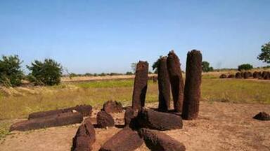


The Nomination files produced by the States Parties are published by the World Heritage Centre at its website and/or in working documents in order to ensure transparency, access to information and to facilitate the preparations of comparative analysis by other nominating States Parties.
The sole responsibility for the content of each Nomination file lies with the State Party concerned. The publication of the Nomination file, including the maps and names, does not imply the expression of any opinion whatsoever of the World Heritage Committee or of the Secretariat of UNESCO concerning the history or legal status of any country, territory, city or area or of its boundaries.
Protections
by other conservation instruments
1 protection / 1 element
2003 Convention for the Safeguarding of the Intangible Cultural Heritage (1 element)