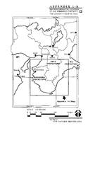
Sacred Sites and Pilgrimage Routes in the Kii Mountain Range
Multiple Locations (23)
| ID | Name & Location | State Party | Coordinates | Property | Buffer Zone |
|---|---|---|---|---|---|
| 1142-01bis | Yoshino and Ômine - Yoshinoyama | Japan |
N34 21 24 E135 52 14 |
33.7 ha | 916 ha |
| 1142-02bis | Yoshino and Ômine - Yoshino Mikumari-jinja | Japan |
N34 21 12.99 E135 52 23.99 |
0.9 ha | |
| 1142-03bis | Yoshino and Ômine - Kimpu-jinja | Japan |
N34 20 34 E135 52 53 |
1.1 ha | |
| 1142-04bis | Yoshino and Ômine - Kimpusen-ji | Japan |
N34 22 6.99 E135 51 28 |
0.9 ha | |
| 1142-05bis | Yoshino and Ômine - Yoshimizu-jinja | Japan |
N34 22 1.99 E135 51 42 |
0.8 ha | |
| 1142-06bis | Yoshino and Ômine - Ôminesan-ji | Japan |
N34 15 18 E135 56 23.99 |
7.4 ha | |
| 1142-07bis | Kumano Sanzan - Kumano Hongû Taisha | Japan |
N33 50 24 E135 46 24.99 |
10.8 ha | 752 ha |
| 1142-08bis | Kumano Sanzan - Kumano Hayatama Taisha | Japan |
N33 43 54.99 E135 59 0.99 |
47.6 ha | |
| 1142-09bis | Kumano Sanzan - Kumano Nachi Taisha | Japan |
N33 40 6.99 E135 53 22.99 |
0.3 ha | |
| 1142-10bis | Kumano Sanzan - Seiganto-ji | Japan |
N33 40 8 E135 53 22.99 |
0.2 ha | |
| 1142-11bis | Kumano Sanzan - Nachi no Ôtaki | Japan |
N33 40 29.99 E135 53 14.99 |
2.5 ha | |
| 1142-12bis | Kumano Sanzan - Nachi Primeval Forest | Japan |
N33 40 33.99 E135 53 29 |
32.7 ha | |
| 1142-13bis | Kumano Sanzan - Fudarakusan-ji | Japan |
N33 38 39.99 E135 56 3 |
0.1 ha | |
| 1142-14bis | Kôyasan - Niutsuhime-jinja | Japan |
N34 15 46 E135 31 18.99 |
1.6 ha | 582 ha |
| 1142-15bis | Kôyasan - Kongôbu-ji | Japan |
N34 12 48.99 E135 35 2 |
61.4 ha | |
| 1142-16bis | Kôyasan - Jison-in | Japan |
N34 17 42 E135 32 58.99 |
0.04 ha | |
| 1142-17bis | Kôyasan - Niukanshôfu-jinja | Japan |
N34 17 39 E135 32 57 |
0.1 ha | |
| 1142-18bis | Pilgrimage Routes - Ômine Okugakemichi | Japan |
N34 10 46.99 E135 54 33.99 |
149.3 ha | 9,850 ha |
| 1142-19bis | Pilgrimage Routes - Kumano Sankeimichi - Nakahechi | Japan |
N33 46 32.99 E135 30 12.99 |
51.1 ha | |
| 1142-20bis | Pilgrimage Routes - Kumano Sankeimichi - Kohechi | Japan |
N34 4 37.99 E135 39 6 |
4.9 ha | |
| 1142-21bis | Pilgrimage Routes - Kumano Sankeimichi - Ôhechi | Japan |
N33 38 26 E135 24 25.99 |
5.1 ha | |
| 1142-22bis | Pilgrimage Routes - Kumano Sankeimichi - Iseji | Japan |
N33 52 46.99 E136 5 35 |
75.8 ha | |
| 1142-23bis | Pilgrimage Routes - Kôya Sankeimichi | Japan |
N34 15 19 E135 31 32.99 |
18.1 ha |
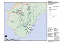
Maps
Disclaimer
The Nomination files produced by the States Parties are published by the World Heritage Centre at its website and/or in working documents in order to ensure transparency, access to information and to facilitate the preparations of comparative analysis by other nominating States Parties.
The sole responsibility for the content of each Nomination file lies with the State Party concerned. The publication of the Nomination file, including the maps and names, does not imply the expression of any opinion whatsoever of the World Heritage Committee or of the Secretariat of UNESCO concerning the history or legal status of any country, territory, city or area or of its boundaries.