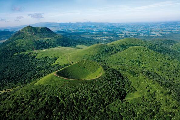
Chaîne des Puys - Limagne fault tectonic arena
Chaîne des Puys - Limagne fault tectonic arena
Situated in the centre of France, the property comprises the long Limagne fault, the alignments of the Chaîne des Puys volcanoes and the inverted relief of the Montagne de la Serre. It is an emblematic segment of the West European Rift, created in the aftermath of the formation of the Alps, 35 million years ago. The geological features of the property demonstrate how the continental crust cracks, then collapses, allowing deep magma to rise and cause uplifting at the surface. The property is an exceptional illustration of continental break-up – or rifting – which is one of the five major stages of plate tectonics.
Description is available under license CC-BY-SA IGO 3.0
Haut lieu tectonique Chaîne des Puys - faille de Limagne
Situé au centre de la France, le bien comprend la longue faille de Limagne, l’alignement des volcans de la Chaîne des Puys et le relief inversé de la Montagne de la Serre. Il s’agit d’un élément emblématique du rift ouest-européen, créé dans le sillage de la formation des Alpes, il y a 35 millions d’années. Les caractéristiques géologiques du bien démontrent comment la croûte continentale se fissure, puis s’effondre, permettant au magma profond de remonter et entraînant un soulèvement de la surface. Le bien illustre de manière exceptionnelle le phénomène de rupture continentale – ou rifting –, qui est l’une des cinq principales étapes de la tectonique des plaques.
Description is available under license CC-BY-SA IGO 3.0
الموقع التكتوني الأعلى لسلسلة الجبال البركانية "شين دي بوي" – وادي "فاي دو ليماين"
يضم الموقع، الموجود في وسط فرنسا، وادي "فاي دو ليماين" وسلسلة الجبال البركانية "لا شين دي بوي" والتضاريس المقلوبة في جبل "لا سير". ويعد الموقع معلماً رمزياً لصدع غرب أوروبا الذي تكوّن في القاعدة الأساسية لبنية جبال الألب منذ 35 مليون عام. وتبيّن الخصائص الجيولوجية للموقع كيف تشقّقت القشرة القارية قبل أن تنهار، الأمر الذي أدى إلى صعود الحمم البركانية المنصهرة في باطن الأرض نحو السطح مؤدية إلى ارتفاع مستوى السطح. ويبيّن الموقع بطريقة استثنائية ظاهرة الانجراف القاري التي تعدّ واحدة من الخطوات الخمس الرئيسية لتكتونيات الصفائح.
source: UNESCO/CPE
Description is available under license CC-BY-SA IGO 3.0
多姆山链,利马涅断层构造区
构造区位于法国中部,包括长利马涅断层,多姆山链火山群和塞拉山倒转地形。它是西欧裂谷的代表性部分,是在阿尔卑斯山于3500万年前形成之后形成的。这里的地质特征体现了大陆地壳是如何裂开然后塌陷,使得深层岩浆上升并引起地表隆起。该遗产地是大陆分裂的极好例证,大陆分裂是板块构造的5个主要阶段之一。
source: UNESCO/CPE
Description is available under license CC-BY-SA IGO 3.0
Тектоно-вулканическая формация горной цепи Шен-де-Пюи и разлома Лимань
Расположенный в центре Франции, этот объект включает длинный разлом Лимань, цепь вулканических гор Шен-де-Пюи и перевернутый рельеф горы Монтань-де-ла-Серр. Объект является важным элементом западноевропейского разлома, возникшего в результате образования Альп 35 млн. лет назад. Геологические особенности объекта демонстрируют процесс образования разломов, а в дальнейшем - разрушений в материковой земной коре, позволяющим магме подняться из глубоких слоев на поверхность. Объект является выдающимся примером континентального разрушения, или рифтинга, одного из пяти основных этапов тектоники плит.
source: UNESCO/CPE
Description is available under license CC-BY-SA IGO 3.0
Sitio tectónico de la cadena volcánica de los Puys y la falla de Limagne
Situado en el centro de Francia, este sitio abarca la larga falla tectónica de Limagne, la cadena volcánica de los Puys y el relieve invertido de la Montaña de la Serre. El sitio es un elemento emblemático de la fosa tectónica alargada de Europa Occidental que se formó hace 35 millones de años a raíz de la elevación de los Alpes. Sus características geológicas muestran cómo la corteza continental se agrieta primero y se hunde después, provocando así la ascensión del magma profundo y la consiguiente elevación de la superficie terrestre. Este sitio constituye un ejemplo excepcional del fenómeno de ruptura continental, que es una de las cinco fases principales de la tectónica de placas.
source: UNESCO/CPE
Description is available under license CC-BY-SA IGO 3.0
