Antiguo sitio agrícola de Kuk
Kuk Early Agricultural Site
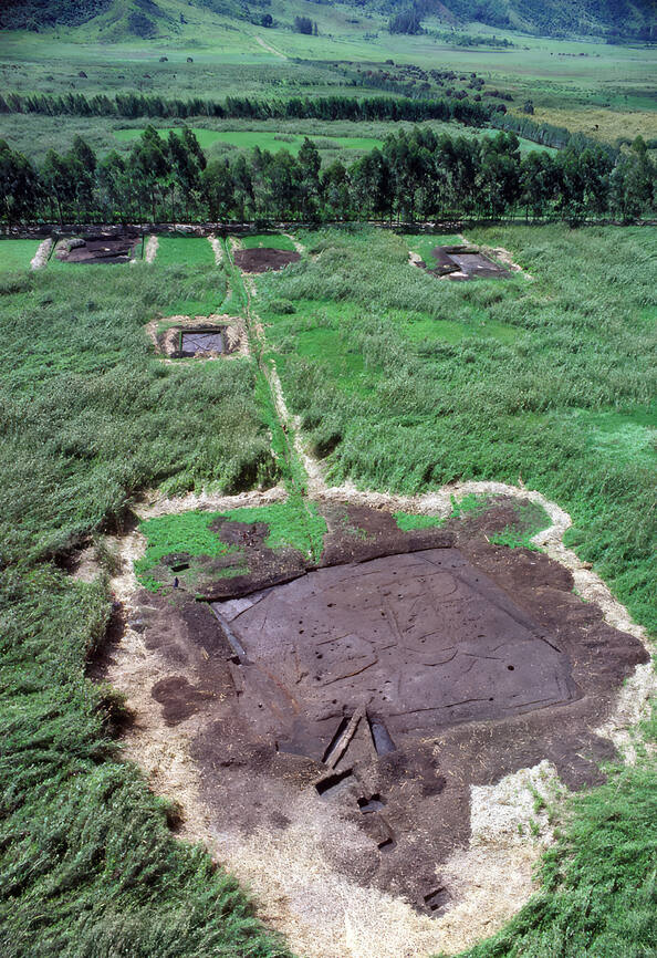
Kuk Early Agricultural Site consists of 116 ha of swamps in the western highlands of New Guinea 1,500 metres above sea-level. Archaeological excavation has revealed the landscape to be one of wetland reclamation worked almost continuously for 7,000, and possibly for 10,000 years. It contains well-preserved archaeological remains demonstrating the technological leap which transformed plant exploitation to agriculture around 6,500 years ago. It is an excellent example of transformation of agricultural practices over time, from cultivation mounds to draining the wetlands through the digging of ditches with wooden tools. Kuk is one of the few places in the world where archaeological evidence suggests independent agricultural development and changes in agricultural practice over such a long period of time.
Description is available under license CC-BY-SA IGO 3.0
Ancien site agricole de Kuk
L’ancien site agricole de Kuk, en Papouasie Nouvelle Guinée, comprend 116 ha de marécages dans l’ouest de l’île de la Nouvelle-Guinée, à 1500 m d’altitude. Des fouilles archéologiques ont révélé que ces marais ont été cultivés presque continuellement depuis 7000, voire 10 000 ans. Le site présente des vestiges archéologiques bien conservés montrant l’évolution technologique qui a transformé l’exploitation des plantes en agriculture, il y a environ 6500 ans. C’est un excellent exemple d’évolution des pratiques agricoles à travers les âges depuis la culture sur des buttes jusqu’au drainage des marécages par le creusement de fossés avec des outils en bois. Kuk est l’un des rares endroits au monde où des vestiges archéologiques montrent un développement indépendant de l’agriculture sur sept à dix millénaires.
Description is available under license CC-BY-SA IGO 3.0
موقع كوك الزراعي البدائي
الموقع كناية عن 116 هكتاراً من المستنقعات، وهو قائم في المرتفعات الجنوبية لغينيا الجديدة، على ارتفاع 1500 متر من سطح البحر. كشفت الحفريات الأثرية أن هذه المنطقة كانت تشكل أحد مراكز استصلاح الأراضي الرطبة على نحو متواصل لمدة 000 7 عام، ولربما 000 10 عام. وهي تحوي آثاراً جيدة الحفظ، تثبت حدوث الوثبة التكنولوجية التي أدت إلى تحول كبير في الأساليب الزراعية قبل نحو 6500 عام. كما أنها تقدم خير مثال على تحول الممارسات الزراعية على مر الزمن، ولا سيما حفر القنوات بواسطة الأدوات الخشبية. ويشكل موقع كوك أحد الأمكنة القليلة في العالم التي تشير فيها الأدلة الأثرية إلى مراحل تطور الزراعة المستقلة والتغيرات في الممارسة الزراعية لفترة تتراوح بين 000 7 و000 10 عام.
المهد العالمي للزراعة رسالة اليونسكو (2008)
source: UNESCO/CPE
Description is available under license CC-BY-SA IGO 3.0
Древнее земледельческое поселение Кука
Древнее земледельческое поселение Кука занимает 116 гектаров болотистой местности на юге Новой Гвинеи (1 500 метров над уровнем моря). Археологические раскопки свидетельствуют о том, что эти болота обрабатывались в течение 7-10 тысяч лет. Здесь сохранились следы перехода от простого использования человеком растений к их выращиванию, произошедшего около 6 500 лет назад. Это прекрасный пример развития сельскохозяйственного производства: от обработки пригорков до осушения болот с помощью рытья канав деревянными инструментами. Это одно из немногих мест в мире, где имеются археологические свидетельства изолированного развития сельского хозяйства на протяжении 7-10 тысячелетий.
source: UNESCO/CPE
Description is available under license CC-BY-SA IGO 3.0
Antiguo sitio agrícola de Kuk
Este sitio abarca 116 hectáreas de terrenos pantanosos del sur de Nueva Guinea situados a unos 1.500 metros de altura. Las excavaciones arqueológicas han mostrado que estos humedales fueron cultivados casi sin interrupción desde unos 7.000 a 10.000 años atrás. En Kuk se conservan, en muy buen estado, vestigios del salto técnico cualitativo que transformó el mero aprovechamiento de las plantas en agricultura hace unos 6.500 años. El sitio es un ejemplo excelente de la evolución de las prácticas agrícolas a lo largo del tiempo, desde el cultivo en montículos a orillas de los pantanos hasta el drenaje de éstos mediante la excavación de zanjas con aperos de madera. Kuk es uno de los pocos sitios del mundo donde los vestigios arqueológicos muestran el desarrollo autónomo de la agricultura a lo largo de un periodo tan largo.
source: UNESCO/CPE
Description is available under license CC-BY-SA IGO 3.0
クックの初期農耕遺跡
パプアニューギニア南部の海抜1500m地点の湿地帯にある、ニューギニア島最古の農耕地。発掘調査で、少なくとも7000年前から耕作が行われてきたことが判明したが、1万年前までさかのぼる可能性もある。タロイモやヤムイモなどの生産活動が、開始以来一度も途絶えていない場所でもある。約6500年前に植物採集が農業へと変わったこの場所では、初めは単なる盛り土をして耕作していた。しかし、やがて木製の道具で溝を掘って湿地を干拓し、4000年前にはバナナの栽培も始まったことが考古学的に証明されている。これほどの長期にわたり、独自の農業の発展や農法の変化について考古学的な裏付けのある場所は、世界にも類がない。source: NFUAJ
Vroeg agrarisch gebied Kuk
Het vroeg agrarische gebied Kuk bestaat uit 116 hectare moerassen in de westelijke hooglanden van Nieuw-Guinea, 1.500 meter boven de zeespiegel. Uit archeologische opgravingen bleek dat het landschap bestaat uit drooggelegd moerasgebied dat 7.000, misschien wel 10.000 jaar continu bewerkt is. Het is een goed voorbeeld van de verandering van landbouw door de tijd heen, van het telen op terpen tot het draineren van de moerassen door het graven van sloten met gereedschap van hout. Kuk is een van de weinige plaatsen ter wereld waar archeologisch bewijs duidt op autonome landbouwontwikkeling en veranderingen in landbouwbeoefening gedurende zo’n lange periode.
Source: unesco.nl
