Quebrada de Humahuaca
Quebrada de Humahuaca
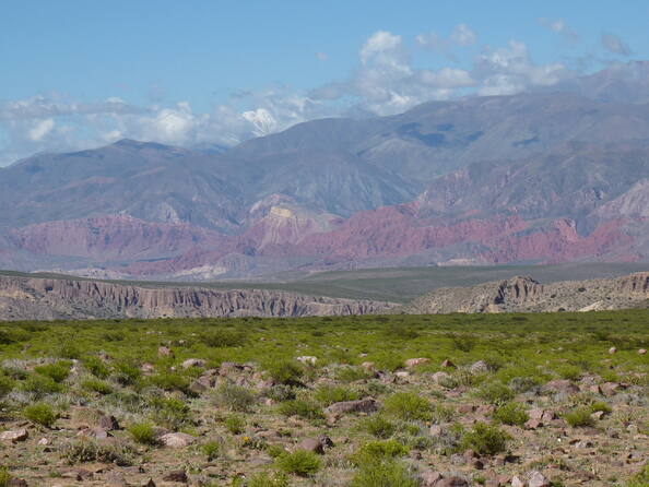
Quebrada de Humahuaca follows the line of a major cultural route, the Camino Inca, along the spectacular valley of the Rio Grande, from its source in the cold high desert plateau of the High Andean lands to its confluence with the Rio Leone some 150 km to the south. The valley shows substantial evidence of its use as a major trade route over the past 10,000 years. It features visible traces of prehistoric hunter-gatherer communities, of the Inca Empire (15th to 16th centuries) and of the fight for independence in the 19th and 20th centuries.
Description is available under license CC-BY-SA IGO 3.0
Quebrada de Humahuaca
Quebrada de Humahuaca suit un itinéraire culturel important, le Camino Inca, le long de la spectaculaire vallée du Rio Grande, depuis sa source dans les hauts plateaux désertiques et froids des Hautes Andes à sa confluence avec le Rio Leone, quelque 150 kilomètres plus au sud. La vallée offre des indices importants de son utilisation comme grande voie commerciale depuis 10 000 ans, et notamment des traces de chasseurs-cueilleurs préhistoriques, de l’Empire inca (XVe-XVIe siècle) et des combats pour l’indépendance (XIXe-XXe siècle).
Description is available under license CC-BY-SA IGO 3.0
كيبرادا دي هوماهواكا
تتبع كيبرادا دي هوماهواكا طريقاً ثقافياً مهماً واسمه "كامينو إنكا" (طريق الإنكا) على طول وادي وادي ريو غراندي الخلاب، منذ مصدره في السفوح العليا الصحراوية والباردة في الأند العليا حتى انضمامه إلى ريو ليوني على مسافة 150 كيلومتراً جنوباً. يعرض الوادي مؤشرات مهمة لاستعمال هذا الطريق كطريق تجارية كبرى منذ 10000 سنة، لا سيما آثار الصيادين- القطّافين التي تعود إلى فترة ما قبل التاريخ، وإلى إمبراطورية الإنكا (القرنان الخامس عشر والسادس عشر) ومعارك الاستقلال (القرنان التاسع عشر والعشرين).
source: UNESCO/CPE
Description is available under license CC-BY-SA IGO 3.0
塔夫拉达•德乌玛瓦卡
塔夫拉达•德乌玛瓦卡遗产地沿一条主要的文化路线——卡米诺印加分布。其源头起自安蒂恩高原(the High Andean lands)上寒冷的荒原,沿格兰德河谷 (the Rio Grande) 延伸,直到南部150公里与莱昂河(the Rio Leone) 汇合处。山谷里的遗迹向世人展示了过去一万年间,它被作为主要的商业通道的历史。有多出明显的遗迹表明,这里曾先后是史前的狩猎军体聚集地,还是印加帝国时代(公元15-16世纪)和19至20世纪人们为独立而斗争的战场。
source: UNESCO/CPE
Description is available under license CC-BY-SA IGO 3.0
Древний путь Кебрада-де-Умауака
Кебрада-де-Умауака следует линии важного культурно-исторического пути, который назывался «Дорога Инки» (Camino Inca) и был проложен вдоль живописной долины Рио-Гранде, от ее истока на холодном пустынном плато Андского высокогорья до слияния с Рио-Леоне в 150 км к югу. В долине сохранились свидетельства ее использования в качестве главного торгового пути в течение последних 10 тыс. лет - следы доисторических сообществ охотников-собирателей, империи инков (XV-XVI вв.) и периода борьбы за независимость в XIХ-XХ вв.
source: UNESCO/CPE
Description is available under license CC-BY-SA IGO 3.0
Quebrada de Humahuaca
Este sitio se extiende a lo largo de un importante itinerario cultural, el Camino del Inca, que sigue el curso del Río Grande y su espectacular valle, desde su nacimiento en el altiplano desértico y frío de los Altos Andes hasta su confluencia con el Río Leone, unos 150 kilómetros más al sur. En el valle hay huellas importantes de su utilización como vía comercial importante desde 10.000 años atrás, así como de las actividades de grupos de cazadores-recolectores prehistóricos. También hay vestigios del imperio inca (siglos XV y XVI) y de los combates de los republicanos por la independencia de Argentina (siglos XIX y XX).
source: UNESCO/CPE
Description is available under license CC-BY-SA IGO 3.0
ケブラーダ・デ・ウマワーカ
アルゼンチン北西端、アンデス山脈上に位置するウマワーカ渓谷は、グランデ川によって切り開かれた155.4㎞ほどの細長い渓谷。渓流はアンデス高地の寒冷ツンドラ地帯から、広大で蒸し暑い南東のフフイ渓谷にまでおよぶ。狩猟時代から現代まで、渓谷は人びとの道の役割を果たしてきた。先住民の居住地は、この渓谷が幹線路として重要であったことを示し、居住地の多様性からも歴史の中で渓谷が果たしてきた役割を知ることができる。source: NFUAJ
Quebrada de Humahuaca vallei
De Quebrada de Humahuaca vallei maakt deel uit van een belangrijke culturele route – de Camino Inca – langs de Rio Grande. De rivier die van de bron op het koude woestijnplateau van de Hoge Andes voert tot aan de plek waar zij 150 kilometer zuidelijker samenvloeit met de Rio Leone. De Quebrada de Humahuaca-vallei laat duidelijk zien dat zij de afgelopen 10.000 jaar gebruikt is als een belangrijke handelsroute. Zo zijn er zichtbare sporen van prehistorische jager-verzamelaargemeenschappen, van het Incarijk – 15e tot de 16e eeuw –, evenals van de strijd voor onafhankelijkheid in de 19e en 20e eeuw.
Source: unesco.nl
