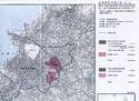
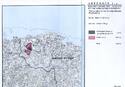
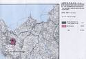
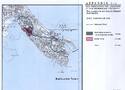
Gusuku Sites and Related Properties of the Kingdom of Ryukyu
Multiple Locations (9)
| ID | Name & Location | State Party | Coordinates | Property | Buffer Zone |
|---|---|---|---|---|---|
| 972-001 | Tamaudun | Japan |
N26 12 0.00 E127 40 60.00 |
1.1 ha | 136.9 ha |
| 972-002 | Sonohyan-utaki Ishimon | Japan |
N26 12 0.00 E127 40 60.00 |
0.008 ha | — |
| 972-003 | Nakijin-jô site | Japan |
N26 41 45.70 E127 55 11.90 |
7.9 ha | 25.3 ha |
| 972-004 | Zakimi-jô site | Japan |
N26 25 19.20 E127 44 6.10 |
4.4 ha | 78.9 ha |
| 972-005 | Katsuren-jô site | Japan |
N26 20 3.20 E127 52 51.10 |
13.2 ha | 44.2 ha |
| 972-006 | Nakagusuku-jô site | Japan |
N26 17 18.80 E127 48 34.00 |
12.3 ha | 178.1 ha |
| 972-007 | Shuri-jô site | Japan |
N26 12 0.00 E127 40 60.00 |
7.3 ha | — |
| 972-008 | Shikinaen | Japan |
N26 12 0.00 E127 40 60.00 |
4.2 ha | 84.2 ha |
| 972-009 | Sêfa-utaki | Japan |
N26 9 40.30 E127 48 24.10 |
4.5 ha | 12.1 ha |
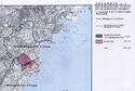
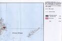
Maps
Disclaimer
The Nomination files produced by the States Parties are published by the World Heritage Centre at its website and/or in working documents in order to ensure transparency, access to information and to facilitate the preparations of comparative analysis by other nominating States Parties.
The sole responsibility for the content of each Nomination file lies with the State Party concerned. The publication of the Nomination file does not imply the expression of any opinion whatsoever of the World Heritage Committee or of the Secretariat of UNESCO concerning the history or legal status of any country, territory, city or area or of its boundaries.