Uvs Nuur Basin
Multiple Locations (12)
| ID | Name & Location | State Party | Coordinates | Property | Buffer Zone |
|---|---|---|---|---|---|
| 769-001 | Mongun Taiga | Russian Federation |
N50 12 0.00 E90 12 0.00 |
1,589 ha | 84,510 ha |
| 769-002 | Ubsu-Nur | Russian Federation |
N50 37 0.00 E93 7 60.00 |
4,490 ha | — |
| 769-003 | Oroku-Shinaa | Russian Federation |
N50 37 0.00 E94 0 0.00 |
28,750 ha | — |
| 769-004 | Aryskannyg | Russian Federation |
N50 40 0.00 E94 43 60.00 |
15,000 ha | 11,800 ha |
| 769-005 | Jamaalyg | Russian Federation |
N50 15 0.00 E94 45 0.00 |
800 ha | 4,000 ha |
| 769-006 | Tsugeer els | Russian Federation |
N50 4 60.00 E95 15 0.00 |
4,900 ha | 50,000 ha |
| 769-007 | Ular | Russian Federation |
N50 31 60.00 E95 37 60.00 |
18,000 ha | 20,480 ha |
| 769-008 | Tsagan shuvuut | Mongolia |
N50 19 0.00 E91 9 0.00 |
23,170 ha | — |
| 769-009 | Turgen | Mongolia |
N49 46 0.00 E91 22 0.00 |
116,831 ha | — |
| 769-010 | Uvs Lake | Mongolia |
N50 19 60.00 E92 52 60.00 |
424,298 ha | — |
| 769-011 | Altan els | Mongolia |
N49 49 60.00 E95 0 0.00 |
148,246 ha | — |
| 769-012 | Tes River | Mongolia |
N50 32 7.904 E93 32 49.657 |
97,688.5 ha | — |
Maps
| Date | Title | |
|---|---|---|
|
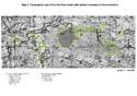
2003 | Uvs Nuur Basin - map of inscribed properties |
Disclaimer
The Nomination files produced by the States Parties are published by the World Heritage Centre at its website and/or in working documents in order to ensure transparency, access to information and to facilitate the preparations of comparative analysis by other nominating States Parties.
The sole responsibility for the content of each Nomination file lies with the State Party concerned. The publication of the Nomination file, including the maps and names, does not imply the expression of any opinion whatsoever of the World Heritage Committee or of the Secretariat of UNESCO concerning the history or legal status of any country, territory, city or area or of its boundaries.