Belize Barrier Reef Reserve System
Multiple Locations (7)
| ID | Name & Location | State Party | Coordinates | Property | Buffer Zone |
|---|---|---|---|---|---|
| 764-001 | Bacalar Chico National Park and Marine Reserve | Belize |
N18 9 30.38 W87 50 9.77 |
10,700 ha | — |
| 764-002 | Blue Hole Natural Monument | Belize |
N17 18 55.71 W87 32 38.95 |
4,100 ha | — |
| 764-003 | Half Moon Caye Natural Monument | Belize |
N17 12 14.97 W87 32 11.74 |
3,900 ha | — |
| 764-004 | South Water Caye Marine Reserve | Belize |
N16 40 1.71 W88 11 35.51 |
29,800 ha | — |
| 764-005 | Glovers Reef Marine Reserve | Belize |
N16 47 59.82 W87 46 59.93 |
30,800 ha | — |
| 764-006 | Laughing Bird Caye National Park | Belize |
N16 26 36.23 W88 11 49.8 |
4,300 ha | — |
| 764-007 | Sapodilla Cayes Marine Reserve | Belize |
N16 6 32.9 W88 16 10.4 |
12,700 ha | — |
Maps
| Date | Title | |
|---|---|---|
|
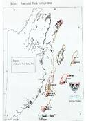
1995 | Belize: World Heritage property |
|
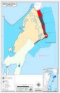
2016 | Belize Barrier Reef Reserve System - Map of inscribed property Clarification / adopted |
Disclaimer
The Nomination files produced by the States Parties are published by the World Heritage Centre at its website and/or in working documents in order to ensure transparency, access to information and to facilitate the preparations of comparative analysis by other nominating States Parties.
The sole responsibility for the content of each Nomination file lies with the State Party concerned. The publication of the Nomination file, including the maps and names, does not imply the expression of any opinion whatsoever of the World Heritage Committee or of the Secretariat of UNESCO concerning the history or legal status of any country, territory, city or area or of its boundaries.