Kilimanjaro National Park
Kilimanjaro National Park
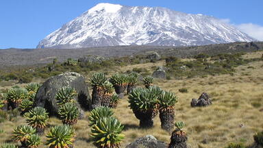
At 5,895 m, Kilimanjaro is the highest point in Africa. This volcanic massif stands in splendid isolation above the surrounding plains, with its snowy peak looming over the savannah. The mountain is encircled by mountain forest. Numerous mammals, many of them endangered species, live in the park.
Description is available under license CC-BY-SA IGO 3.0
Parc national du Kilimandjaro
Point culminant de l’Afrique à une altitude de 5 895 m, le Kilimandjaro est un massif volcanique dont la cime isolée, couverte de neiges éternelles, surplombe la savane avoisinante. Il est entouré d’une forêt de montagne et abrite de nombreux mammifères, dont beaucoup appartiennent à des espèces menacées.
Description is available under license CC-BY-SA IGO 3.0
منتزه كيليمانجارو الوطني
روضة كيليمانجارو الوطنية يشكل كيليمانجارو أعلى نقطة في افريقيا إذ يبلغ ارتفاعه 5895 متراً. وهو عبارة عن كتلة بركانية تطل بقمتها المعزولة المغطاة بالثلوج الأزلية على السافانا المجاورة وتحيط بها غابة جبلية، كما تحتضن عدداً كبيراً من الثدييات التي ينتمي الكثير منها الى أصناف مهددة.
source: UNESCO/CPE
Description is available under license CC-BY-SA IGO 3.0
乞力马扎罗国家公园
乞力马扎罗山是非洲的制高点,它是一个火山丘,有5895米高,矗立在周围的草原之上,它那终年积雪的山顶在大草原上若隐若现。乞力马扎罗山四周都是山林,那里生活着众多的哺乳动物,其中一些还属于濒于灭绝的种类。
source: UNESCO/CPE
Description is available under license CC-BY-SA IGO 3.0
Национальный парк Килиманджаро
Гора Килиманджаро (5963 м) – самая высокая точка Африки. Этот вулканический горный массив со снежной вершиной ярко выделяется на фоне окружающих его равнинных саванн. Склоны горы покрыты тропическим лесом. Здесь обитают разнообразные млекопитающие, многие из которых признаны исчезающими.
source: UNESCO/CPE
Description is available under license CC-BY-SA IGO 3.0
Parque Nacional del Kilimanjaro
El macizo volcánico del Kilimanjaro, rematado por su célebre pico de 5.895 metros de altitud, es el “techo” del continente africano. Cubierta de nieves perpetuas, su cima se yergue solitaria en medio de la sabana circundante y está rodeada por un bosque de montaña donde viven numerosas especies de mamíferos, muchas de las cuales se hallan en peligro de extinción.
source: UNESCO/CPE
Description is available under license CC-BY-SA IGO 3.0
キリマンジャロ国立公園
source: NFUAJ
Nationaal park Kilimanjaro
Source: unesco.nl
Outstanding Universal Value
Brief synthesis
Kilimanjaro National Park covering an area of some 75,575 ha protects the largest free standing volcanic mass in the world and the highest mountain in Africa, rising 4877m above surrounding plains to 5895m at its peak. With its snow-capped peak, the Kilimanjaro is a superlative natural phenomenon, standing in isolation above the surrounding plains overlooking the savannah.
Criterion vii: Mount Kilimanjaro is one of the largest volcanoes in the world. It has three main volcanic peaks, Kibo, Mawenzi, and Shira. With its snow-capped peak and glaciers, it is the highest mountain in Africa. The mountain has five main vegetation zones from the lowest to the highest point: Lower slopes, montane forest, heath and moorland, alpine desert and summit. The whole mountain including the montane forest belt is very rich in species, in particular mammals, many of them endangered species. For this combination of features but mostly its height, its physical form and snow cap and its isolation above the surrounding plains, Mount Kilimanjaro is considered an outstanding example of a superlative natural phenomenon.
Integrity
Kilimanjaro National Park, established in 1973, initially comprised the whole of the mountain above the tree line and six forest corridors stretching down through the montane forest belt. At the time of inscription in 1987, the main pressures affected mostly the forest reserve which acted as a buffer zone to the park. The World Heritage Committee recommended extending the national park to include more areas of montane forest. Following a 2005 extension, the National Park includes the whole of the mountain above the tree line as well as the natural forest (montane forest) which was under Kilimanjaro Forest Reserve, and as such fulfils the criteria of integrity. It is important that the extension of the National Park be reflected in the boundaries of the property.
The wildlife of the property is important to the experience of Kilimanjaro, although the property is not inscribed in relation to biodiversity criteria. Pressures on elephant, buffalo and antelope, and logging in the Forest Reserve area, were noted as integrity concerns at the time of inscription. The park is connected to Amboseli National Park, however corridors to Arusha National Park and Tsavo National park have been encroached, impacting on wildlife migration.
Protection and management requirements
Kilimanjaro National Park is protected under national legislation as a National Park and a management plan is in place. The property requires an effective and managing organization, including sufficient well equipped ranger presence to be able to carry out surveillance and implementation of the management plan. A key management issue is maintaining the aesthetic quality of the property as a spectacular natural site. Protecting its visual integrity and sustaining its natural integrity are key management issues. Key viewpoints to the property also need to be protected, including from Arusha and Amboseli where the most famous views of the property can be seen. An effective programme of research and monitoring of the property is also required.
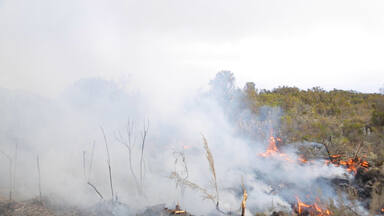
Threats to the property include increasing and cumulative stress from sources such as adjacent land uses, downstream effects of air and water pollution, invasive species, fire and climate change. The glaciers of the property are vulnerable to retreat, and are cited as a feature of particular vulnerability to global climate change. The impacts from these threats need to be closely monitored and minimized. Tourism poses a significant threat and careful planning of related infrastructure and access development is required. Human pressure on the property needs to be managed, which can result otherwise in illegal harvest of its resources, encroachments to park boundary and blockage of migratory routes and dispersal areas. Education programmes and integration of park management with all involved partners and stakeholders, including the surrounding rural population, is essential.


