Hill Forts of Rajasthan
Multiple Locations (6)
| ID | Name & Location | State Party | Coordinates | Property | Buffer Zone |
|---|---|---|---|---|---|
| 247rev-001 | Chittorgarh Fort | India |
N24 52 60.00 E74 38 46.00 |
305 ha | 440 ha |
| 247rev-002 | Kumbhalgarh Fort | India |
N25 8 56.00 E73 34 49.00 |
268 ha | 1,339 ha |
| 247rev-003 | Ranthambore Fort | India |
N26 1 13.00 E76 27 18.00 |
102 ha | 372 ha |
| 247rev-004 | Gagron Fort | India |
N24 37 35.00 E76 11 14.00 |
23 ha | 722 ha |
| 247rev-005 | Amber Fort | India |
N26 59 5.00 E75 51 7.00 |
30 ha | 498 ha |
| 247rev-006 | Jaisalmer Fort | India |
N26 54 45.00 E70 54 45.00 |
8 ha | 89 ha |
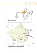
Maps
| Date | Title | |
|---|---|---|
|
2013 | Hill Forts of Rajasthan - map of inscribed property |
Disclaimer
The Nomination files produced by the States Parties are published by the World Heritage Centre at its website and/or in working documents in order to ensure transparency, access to information and to facilitate the preparations of comparative analysis by other nominating States Parties.
The sole responsibility for the content of each Nomination file lies with the State Party concerned. The publication of the Nomination file, including the maps and names, does not imply the expression of any opinion whatsoever of the World Heritage Committee or of the Secretariat of UNESCO concerning the history or legal status of any country, territory, city or area or of its boundaries.