Hopewell Ceremonial Earthworks
Multiple Locations (8)
| ID | Name & Location | State Party | Coordinates | Property | Buffer Zone |
|---|---|---|---|---|---|
| 1689-001 | Octagon Earthworks | United States of America |
N40 3 13.17 W82 26 45.82 |
43.2 ha | 30.3 ha |
| 1689-002 | Great Circle Earthworks | United States of America |
N40 2 28.44 W82 25 48.43 |
20.2 ha | 16.5 ha |
| 1689-003 | Hopeton Earthworks | United States of America |
N39 23 5.25 W82 58 44.96 |
22.7 ha | 80.4 ha |
| 1689-004 | Mound City | United States of America |
N39 22 35.36 W83 0 14.36 |
13.1 ha | 34 ha |
| 1689-005 | High Bank Works | United States of America |
N39 17 54.82 W82 55 6.56 |
26 ha | 30.4 ha |
| 1689-006 | Hopewell Mound Group | United States of America |
N39 21 39.54 W83 5 36.14 |
69.5 ha | 59.9 ha |
| 1689-007 | Seip Earthworks | United States of America |
N39 14 14.89 W83 13 11.37 |
56.2 ha | 107.3 ha |
| 1689-008 | Fort Ancient | United States of America |
N39 24 12.1 W84 5 33.18 |
69.8 ha | 203 ha |
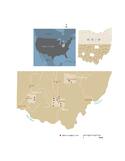
Maps
| Date | Title | |
|---|---|---|
|
2023 | Hopewell Ceremonial Earthworks - Maps of the inscribed property |
Disclaimer
The Nomination files produced by the States Parties are published by the World Heritage Centre at its website and/or in working documents in order to ensure transparency, access to information and to facilitate the preparations of comparative analysis by other nominating States Parties.
The sole responsibility for the content of each Nomination file lies with the State Party concerned. The publication of the Nomination file does not imply the expression of any opinion whatsoever of the World Heritage Committee or of the Secretariat of UNESCO concerning the history or legal status of any country, territory, city or area or of its boundaries.