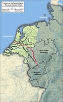
Frontiers of the Roman Empire – The Lower German Limes
Multiple Locations (102)
| ID | Name & Location | State Party | Coordinates | Property | Buffer Zone |
|---|---|---|---|---|---|
| 1631-001 | Valkenburg-Centrum | Netherlands (Kingdom of the) |
N52 10 49.2 E4 25 58.8 |
2.6 ha | 18.74 ha |
| 1631-002 | Valkenburg-De Woerd | North | Netherlands (Kingdom of the) |
N52 10 19 E4 26 16.98 |
0.97 ha | 12.18 ha |
| 1631-003 | Valkenburg-De Woerd | South | Netherlands (Kingdom of the) |
N52 10 12 E4 26 24 |
3.26 ha | |
| 1631-004 | Voorburg-Arentsburg | Netherlands (Kingdom of the) |
N52 3 36 E4 21 0 |
11.89 ha | 6.48 ha |
| 1631-005 | Corbulo's canal | Vlietwijk | Netherlands (Kingdom of the) |
N52 7 30 E4 27 36 |
3.31 ha | 167.09 ha |
| 1631-006 | Corbulo's canal | Starrenburg | Netherlands (Kingdom of the) |
N52 6 32 E4 26 12.98 |
1.31 ha | |
| 1631-007 | Corbulo's canal | Knippolder | Netherlands (Kingdom of the) |
N52 6 17.98 E4 25 44 |
2.76 ha | |
| 1631-008 | Corbulo's canal | Vlietvoorde | Netherlands (Kingdom of the) |
N52 6 3.98 E4 25 23 |
2.3 ha | |
| 1631-009 | Corbulo's canal | Rozenrust | Netherlands (Kingdom of the) |
N52 5 27.98 E4 24 32 |
0.75 ha | |
| 1631-010 | Corbulo's canal | Romeinsepad | Netherlands (Kingdom of the) |
N52 5 2 E4 23 56 |
0.44 ha | |
| 1631-011 | Leiden-Roomburg | Park Matilo | Netherlands (Kingdom of the) |
N52 8 58.94 E4 31 3.78 |
8.16 ha | 10.37 ha |
| 1631-012 | Leiden-Roomburg | Besjeslaan | Netherlands (Kingdom of the) |
N52 8 52.98 E4 31 8 |
2.61 ha | |
| 1631-013 | Woerden-Centrum | Netherlands (Kingdom of the) |
N52 5 9.98 E4 53 2 |
1.44 ha | 5.94 ha |
| 1631-014 | Utrecht-Limes road | Zandweg | Netherlands (Kingdom of the) |
N52 5 27.98 E4 59 45.98 |
0.39 ha | 12.45 ha |
| 1631-015 | Utrecht-Limes road | Veldhuizen | Netherlands (Kingdom of the) |
N52 5 8.08 E5 0 29.49 |
0.46 ha | |
| 1631-016 | Utrecht-Limes road | De Balije | Netherlands (Kingdom of the) |
N52 4 47.99 E5 1 19 |
3.32 ha | |
| 1631-017 | Utrecht-Hoge Woerd | Netherlands (Kingdom of the) |
N52 5 11 E5 2 33.09 |
12.63 ha | 21.77 ha |
| 1631-018 | Utrecht-Groot Zandveld | Netherlands (Kingdom of the) |
N52 5 41.98 E5 3 3.98 |
0.83 ha | 2.84 ha |
| 1631-019 | Utrecht-Domplein | Netherlands (Kingdom of the) |
N52 5 27.98 E5 7 19 |
2.64 ha | 8.96 ha |
| 1631-020 | Bunnik-Vechten | Marsdijk | Netherlands (Kingdom of the) |
N52 3 29 E5 9 57.98 |
80.83 ha | 51.88 ha |
| 1631-021 | Bunnik-Vechten | Provincialeweg | Netherlands (Kingdom of the) |
N52 3 47 E5 10 26 |
0.94 ha | |
| 1631-022 | Arnhem-Meinerswijk | Netherlands (Kingdom of the) |
N51 58 15.99 E5 52 26 |
2.75 ha | 4.12 ha |
| 1631-023 | Elst-Grote Kerk | Netherlands (Kingdom of the) |
N51 55 11.4 E5 50 57.38 |
0.39 ha | 0.5 ha |
| 1631-024 | Nijmegen-Valkhof area | Valkhofpark | Netherlands (Kingdom of the) |
N51 50 52.98 E5 52 11.99 |
2.43 ha | 3,712.38 ha |
| 1631-025 | Nijmegen-Valkhof area | Hunnerpark | Netherlands (Kingdom of the) |
N51 50 48.98 E5 52 19 |
2.37 ha | |
| 1631-026 | Nijmegen-Hunerberg | Netherlands (Kingdom of the) |
N51 50 21.18 E5 52 56.2 |
50.13 ha | |
| 1631-027 | Nijmegen-Kops Plateau | West | Netherlands (Kingdom of the) |
N51 50 16.98 E5 53 30.98 |
4.03 ha | |
| 1631-028 | Nijmegen-Kops Plateau | North | Netherlands (Kingdom of the) |
N51 50 20 E5 53 41.98 |
0.86 ha | |
| 1631-029 | Nijmegen-Kops Plateau | East | Netherlands (Kingdom of the) |
N51 50 9.98 E5 53 41.98 |
0.77 ha | |
| 1631-030 | Nijmegen-Kops Plateau | Kopse Hof North | Netherlands (Kingdom of the) |
N51 50 8.61 E5 53 45.03 |
0.16 ha | |
| 1631-031 | Nijmegen-Kops Plateau | Kopse Hof South | Netherlands (Kingdom of the) |
N51 50 5.98 E5 53 45.98 |
0.93 ha | |
| 1631-032 | Berg en Dal-aqueduct | Mariënboom | Netherlands (Kingdom of the) |
N51 49 32.62 E5 53 15.62 |
1.53 ha | |
| 1631-033 | Berg en Dal-aqueduct | Swartendijk | Netherlands (Kingdom of the) |
N51 49 23 E5 53 27.98 |
0.66 ha | |
| 1631-034 | Berg en Dal-aqueduct | Cortendijk | Netherlands (Kingdom of the) |
N51 49 10.41 E5 53 25.72 |
0.26 ha | |
| 1631-035 | Berg en Dal-aqueduct | Louisedal | Netherlands (Kingdom of the) |
N51 49 5 E5 54 0 |
5.86 ha | |
| 1631-036 | Berg en Dal-aqueduct | Kerstendal | Netherlands (Kingdom of the) |
N51 48 50.4 E5 54 50.4 |
9.71 ha | |
| 1631-037 | Berg en Dal-De Holdeurn | North | Netherlands (Kingdom of the) |
N51 49 1 E5 55 59 |
0.56 ha | 3.9 ha |
| 1631-038 | Berg en Dal-De Holdeurn | South | Netherlands (Kingdom of the) |
N51 48 57.98 E5 55 55 |
7.03 ha | 17.22 ha |
| 1631-039 | Herwen-De Bijland | Netherlands (Kingdom of the) |
N51 52 51.99 E6 5 56 |
2.07 ha | 1,013.14 ha |
| 1631-040 | Kleve-Keeken | Germany |
N51 50 27.98 E6 4 41 |
4.52 ha | 374.71 ha |
| 1631-041 | Kleve-Reichswald | West | Germany |
N51 47 27.6 E6 5 34.8 |
0.42 ha | 7.31 ha |
| 1631-042 | Kleve-Reichswald | East | Germany |
N51 47 29.22 E6 6 20.25 |
0.17 ha | |
| 1631-043 | Till | Germany |
N51 46 37 E6 14 20 |
75.84 ha | 150.98 ha |
| 1631-044 | Kalkar-Kalkarberg | Germany |
N51 43 44 E6 17 6 |
1.83 ha | 5.05 ha |
| 1631-045 | Kalkar-Bornsches Feld | Germany |
N51 42 50 E6 19 8 |
47.18 ha | 108.31 ha |
| 1631-046 | Uedem-Hochwald | Hochwald 1 | Germany |
N51 41 30.98 E6 21 6.99 |
2.93 ha | 106.16 ha |
| 1631-047 | Uedem-Hochwald | Hochwald 2 | Germany |
N51 41 38 E6 21 14 |
1.34 ha | |
| 1631-048 | Uedem-Hochwald | Hochwald 3 | Germany |
N51 41 30.98 E6 21 24.99 |
2.45 ha | |
| 1631-049 | Uedem-Hochwald | Hochwald 4 | Germany |
N51 41 30.98 E6 21 36 |
1.47 ha | |
| 1631-050 | Uedem-Hochwald | Hochwald 5 | Germany |
N51 41 34.98 E6 21 47 |
1.63 ha | |
| 1631-051 | Uedem-Hochwald | Hochwald 6 | Germany |
N51 41 27.98 E6 22 1 |
0.66 ha | |
| 1631-052 | Uedem-Hochwald | Hochwald 7.1 | Germany |
N51 41 21.48 E6 21 59.28 |
0.57 ha | |
| 1631-053 | Uedem-Hochwald | Hochwald 7.2 | Germany |
N51 41 22.06 E6 22 4.18 |
0.56 ha | |
| 1631-054 | Uedem-Hochwald | Hochwald 8.1 | Germany |
N51 41 18.38 E6 21 52.89 |
0.16 ha | |
| 1631-055 | Uedem-Hochwald | Hochwald 8.2 | Germany |
N51 41 16.98 E6 21 54 |
0.69 ha | |
| 1631-056 | Uedem-Hochwald | Hochwald 9 | Germany |
N51 41 23.98 E6 21 54 |
1.27 ha | |
| 1631-057 | Uedem-Hochwald | Hochwald 10 | Germany |
N51 41 20 E6 21 42.99 |
1.31 ha | |
| 1631-058 | Uedem-Hochwald | Hochwald 11 | Germany |
N51 41 16.98 E6 21 32 |
1.55 ha | |
| 1631-059 | Uedem-Hochwald | Hochwald 12 | Germany |
N51 41 21.73 E6 21 16.19 |
0.86 ha | |
| 1631-060 | Uedem-Hochwald | Hochwald 13 | Germany |
N51 41 20 E6 21 3.98 |
1.65 ha | |
| 1631-061 | Wesel-Flüren | Flürener Feld 1 | Germany |
N51 40 55 E6 33 32 |
1.5 ha | 84.86 ha |
| 1631-062 | Wesel-Flüren | Flürener Feld 2 | Germany |
N51 40 59 E6 33 39.98 |
1.17 ha | |
| 1631-063 | Wesel-Flüren | Flürener Feld 3 | Germany |
N51 41 6 E6 33 42.99 |
2.51 ha | |
| 1631-064 | Wesel-Flüren | Flürener Feld 4 | Germany |
N51 41 6 E6 33 50 |
2.67 ha | |
| 1631-065 | Xanten-CUT | Germany |
N51 40 1 E6 26 38 |
90.19 ha | 39.86 ha |
| 1631-066 | Xanten-Fürstenberg | Germany |
N51 38 23.28 E6 28 10.8 |
126.17 ha | 137.08 ha |
| 1631-067 | Alpen-Drüpt | Germany |
N51 35 12.98 E6 32 45.98 |
36.2 ha | 53.7 ha |
| 1631-068 | Moers-Asberg | Germany |
N51 25 55 E6 40 11.99 |
7.56 ha | 40.61 ha |
| 1631-069 | Duisburg-Werthausen | Germany |
N51 25 19.59 E6 42 40.88 |
0.31 ha | 1.13 ha |
| 1631-070 | Krefeld-Gellep | Germany |
N51 19 59 E6 40 55 |
3.36 ha | 12.14 ha |
| 1631-071 | Neuss-Koenenlager | Germany |
N51 10 55 E6 43 26 |
28.51 ha | 141.13 ha |
| 1631-072 | Neuss-Reckberg | Wachtturm | Germany |
N51 10 32.19 E6 45 58.29 |
0.01 ha | 37.83 ha |
| 1631-073 | Neuss-Reckberg | Kleinkastell | Germany |
N51 10 27.5 E6 46 6.99 |
0.27 ha | |
| 1631-074 | Monheim-Haus Bürgel | Germany |
N51 7 44 E6 52 23 |
2.48 ha | 8.61 ha |
| 1631-075 | Dormagen | Germany |
N51 5 34.98 E6 50 23.98 |
5.81 ha | 35.42 ha |
| 1631-076 | Köln-Praetorium | Germany |
N50 56 16.98 E6 57 32 |
1.32 ha | 97.66 ha |
| 1631-077 | Köln-Deutz | Germany |
N50 56 16.98 E6 58 11.99 |
2.39 ha | 32.61 ha |
| 1631-078 | Köln-Alteburg | Germany |
N50 54 18 E6 58 33.6 |
6.03 ha | 55.43 ha |
| 1631-079 | Kottenforst Nord | Am Weißen Stein 1 | Germany |
N50 44 5.96 E6 58 37 |
2.68 ha | 23.68 ha |
| 1631-080 | Kottenforst Nord | Am Weißen Stein 2 | Germany |
N50 43 51.99 E6 58 59 |
0.72 ha | |
| 1631-081 | Kottenforst Nord | Domhecken 5 | Germany |
N50 42 50 E6 57 39.98 |
1.65 ha | 82.98 ha |
| 1631-082 | Kottenforst Nord | Domhecken 1 | Germany |
N50 42 50 E6 58 23 |
3.79 ha | |
| 1631-083 | Kottenforst Nord | Domhecken 2 | Germany |
N50 43 1 E6 58 41 |
2.11 ha | |
| 1631-084 | Kottenforst Nord | Domhecken 3 | Germany |
N50 42 54 E6 58 55 |
1.9 ha | |
| 1631-085 | Kottenforst Nord | Domhecken 4 | Germany |
N50 42 57.98 E6 59 9.98 |
1.9 ha | |
| 1631-086 | Kottenforst Nord | Dürrenbruch 3 | Germany |
N50 42 32 E6 59 9.98 |
0.45 ha | 10.43 ha |
| 1631-087 | Kottenforst Nord | Dürrenbruch 2 | Germany |
N50 42 29 E6 59 16.98 |
1.68 ha | |
| 1631-088 | Kottenforst Nord | Dürrenbruch 1 | Germany |
N50 42 24.99 E6 59 27.98 |
3.05 ha | |
| 1631-089 | Kottenforst Nord | Pfaffenmaar 1 and 2 | Germany |
N50 42 21.98 E6 58 33.99 |
6.04 ha | 5.57 ha |
| 1631-090 | Bonn | Germany |
N50 44 42 E7 6 0 |
31.01 ha | 210.98 ha |
| 1631-091 | Kottenforst Süd | Oben der Krayermaar | Germany |
N50 41 34.98 E7 2 38 |
1.9 ha | 4.49 ha |
| 1631-092 | Kottenforst Süd | Villiper Bach | Germany |
N50 39 39.98 E7 4 51.99 |
1.09 ha | 175.04 ha |
| 1631-093 | Kottenforst Süd | Professorenweg 1 | Germany |
N50 39 32 E7 5 20 |
0.94 ha | |
| 1631-094 | Kottenforst Süd | Professorenweg 2 | Germany |
N50 39 32 E7 5 38 |
0.77 ha | |
| 1631-095 | Kottenforst Süd | Riesenweg | Germany |
N50 39 24.99 E7 5 41.98 |
1.09 ha | |
| 1631-096 | Kottenforst Süd | Wattendorfer Allee 2 | Germany |
N50 39 53.14 E7 5 59.67 |
1.56 ha | |
| 1631-097 | Kottenforst Süd | Wattendorfer Allee 1 | Germany |
N50 39 50 E7 6 29 |
1.79 ha | |
| 1631-098 | Kottenforst Süd | Bellerbuschallee | Germany |
N50 39 57.98 E7 7 5 |
1.52 ha | |
| 1631-099 | Kottenforst Süd | Villiprot | Germany |
N50 38 42 E7 4 12 |
1.78 ha | 10.3 ha |
| 1631-100 | Kottenforst Süd | Heiderhof | Germany |
N50 39 24.99 E7 8 34.98 |
1.46 ha | 1.1 ha |
| 1631-101 | Iversheim | Germany |
N50 35 17.48 E6 46 26.1 |
0.08 ha | 10.72 ha |
| 1631-102 | Remagen | Germany |
N50 34 40.8 E7 14 2.4 |
37.93 ha | 60.7 ha |
Disclaimer
The Nomination files produced by the States Parties are published by the World Heritage Centre at its website and/or in working documents in order to ensure transparency, access to information and to facilitate the preparations of comparative analysis by other nominating States Parties.
The sole responsibility for the content of each Nomination file lies with the State Party concerned. The publication of the Nomination file does not imply the expression of any opinion whatsoever of the World Heritage Committee or of the Secretariat of UNESCO concerning the history or legal status of any country, territory, city or area or of its boundaries.