Garrison Border Town of Elvas and its Fortifications
Multiple Locations (7)
| ID | Name & Location | State Party | Coordinates | Property | Buffer Zone |
|---|---|---|---|---|---|
| 1367bis-001 | Amoreira Aqueduct | Portugal |
N38 52 40.82 W7 10 20.93 |
0.8148 ha | 690 ha |
| 1367bis-002 | Historic Centre | Portugal |
N38 52 50.22 W7 9 47.95 |
125.4311 ha | |
| 1367bis-003 | Fort of Santa Luzia and the covered way | Portugal |
N38 52 22.63 W7 9 29.78 |
19.7116 ha | |
| 1367bis-004 | Fort of Garça | Portugal |
N38 53 40.61 W7 9 51 |
11.2544 ha | |
| 1367bis-005 | Fortlet of São Mamede | Portugal |
N38 52 16.34 W7 9 16.8 |
7.9608 ha | |
| 1367bis-006 | Fortlet of São Pedro | Portugal |
N38 52 18.59 W7 9 54.59 |
1.9843 ha | |
| 1367bis-007 | Fortlet of São Domingos | Portugal |
N38 52 39.59 W7 10 37.13 |
12.1989 ha |
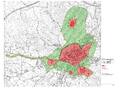
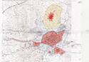
Maps
Disclaimer
The Nomination files produced by the States Parties are published by the World Heritage Centre at its website and/or in working documents in order to ensure transparency, access to information and to facilitate the preparations of comparative analysis by other nominating States Parties.
The sole responsibility for the content of each Nomination file lies with the State Party concerned. The publication of the Nomination file, including the maps and names, does not imply the expression of any opinion whatsoever of the World Heritage Committee or of the Secretariat of UNESCO concerning the history or legal status of any country, territory, city or area or of its boundaries.