Umm Al-Jimāl
Umm Al-Jimāl
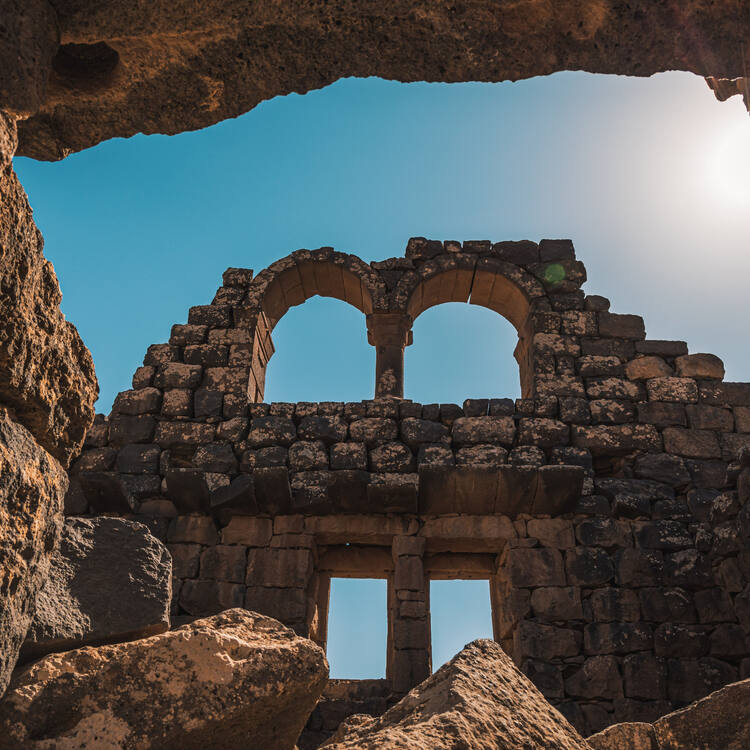
The property is a rural settlement in northern Jordan that developed organically on the site of an earlier Roman settlement around the 5th century CE and functioned until the end of the 8th century CE. It preserves basaltic structures from the Byzantine and Early Islamic periods that represent the local architecture style of the Hauran region, with some earlier Roman military buildings re-purposed by later inhabitants. The settlement formed part of a broader agricultural landscape that included a complex water catchment system, which sustained agriculture and animal herding. The earliest structures uncovered at Umm Al-Jimāl date back to the 1st century CE, when the area formed part of the Nabataean Kingdom. A rich epigraphic corpus in Greek, Nabataean, Safaitic, Latin and Arabic uncovered on the site and spanning many centuries provides insights into its history, and sheds light on the changes in its inhabitants’ religious beliefs.
Description is available under license CC-BY-SA IGO 3.0
Umm Al-Jimāl
Ce bien est un établissement rural du nord de la Jordanie qui se développa de manière organique sur le site d’un établissement romain antérieur vers le Ve siècle de notre ère et fonctionna jusqu’au VIIIe siècle de notre ère. Il préserve les structures basaltiques de la période byzantine et du début de la période islamique, qui représentent le style architectural local de la région du Hauran, avec quelques bâtiments militaires romains plus anciens reconvertis par les habitants ultérieurs. L’établissement faisait partie d’un paysage agricole plus large qui comprenait un système élaboré de captage des eaux, lequel soutenait les activités de culture et d’élevage. Les plus anciennes structures découvertes à Umm Al-Jimāl remontent au Ier siècle de notre ère, lorsque cette zone faisait partie du royaume nabatéen. Un riche corpus épigraphique en grec, nabatéen, safaïtique, latin et arabe, découvert sur le site et couvrant plusieurs siècles, donne un aperçu de son histoire et met en lumière les changements dans les croyances religieuses de ses habitants.
Description is available under license CC-BY-SA IGO 3.0
أم الجِمال
تقع أم الجِمال في البادية الشمالية الأردنية حيث كانت قد تطورت في موقع إحدى المستوطنات الرومانية السابقة بحدود القرن الخامس الميلادي، وظلت فاعلة حتى نهاية القرن الثامن الميلادي. تحتفظ أم الجِمال ببِنى بازلتية يعود تاريخها إلى الفترة البيزنطية وعصر صدر الإسلام. وتجسد هذه البنى طراز العمارة المحلية في منطقة حوران، وتحتفظ أم الجِمال أيضاً بمبان رومانية عسكرية أعاد السكان الذين قطنوها فيما بعد استغلالها لأغراض أخرى. كانت أم الجِمال جزءاً من منظر طبيعي زراعي أوسع نطاقاً يشمل نظاماً معقداً لتجميع المياه، مما ساهم في استدامة الزراعة ورعي الماشية. ويعود تاريخ أقدم البنى المكتشفة في أم الجِمال إلى القرن الأول الميلادي عندما كانت المنطقة جزءاً من مملكة الأنباط. ويكتنز الموقع نقوشاً نفيسة اكتُشفت باللغات اليونانية والنبطية والصفوية واللاتينية والعربية وتروي حكايات تمتد عبر قرون عديدة، وتوفر رؤية متعمقة لتاريخ الموقع، وتُبرز التغيرات التي طرأت على المعتقدات الدينية لسكان المنطقة.
source: UNESCO/CPE
Description is available under license CC-BY-SA IGO 3.0
乌姆吉马尔
乌姆吉马尔(Umm Al-Jimāl)是约旦北部的乡村聚落,大约于公元5世纪在早期罗马定居点的基础上自然发展起来,并一直延续到8世纪末。它保留了拜占庭时期和早期伊斯兰时期的玄武岩建筑,展现了霍兰(Hauran)地区的建筑风格,以及一些被后来的居民改作他用的原罗马军事建筑。聚落所在的广袤农业景观还包括一个复杂的集水系统,维持着农业和畜牧业的发展。乌姆吉马尔发掘的最早期建筑可追溯至公元1世纪,当时该地区是纳巴泰王国的疆域。这里出土了丰富的希腊文、纳巴泰文、萨法伊文、拉丁文、阿拉伯文铭文资料,跨越多个世纪,为深入了解当地历史提供了依据,并揭示了居民宗教信仰的演变。
source: UNESCO/CPE
Description is available under license CC-BY-SA IGO 3.0
Умм аль-Джималь
Объект представляет собой сельское поселение в северной Иордании. Оно сформировалось на месте более раннего римского поселения примерно в V веке н. э. и существовало до конца VIII века н. э. Здесь сохранились базальтовые постройки византийского периода и периода раннего ислама, отражающие местный архитектурный стиль региона Хауран, а также некоторые ранние римские военные здания, переоборудованные последующими обитателями. Поселение было частью обширного сельскохозяйственного ландшафта, включавшего сложную водосборную систему, которая использовалась для сельского хозяйства и животноводства. Самые ранние постройки, обнаруженные в Умм аль-Джимале, относятся к I веку н. э., когда эта территория входила в состав Набатейского царства. Обнаруженный на месте раскопок и охватывающий многие века богатый корпус эпиграфических источников на греческом, набатейском, сафаитском, латинском и арабском языках дает представление о его истории и об изменениях в религиозных верованиях жителей.
source: UNESCO/CPE
Description is available under license CC-BY-SA IGO 3.0
Umm Al-Jimāl
Se trata de un asentamiento rural al norte de Jordania que se desarrolló de manera natural en el emplazamiento que ocupaba un asentamiento romano anterior en torno al siglo V e. c. y que se mantuvo activo hasta el final del siglo VIII e. c. El bien conserva estructuras de basalto de la época bizantina y del inicio del periodo islámico, que representan el estilo arquitectónico local de la región del Haurán. También cuenta con algunos edificios militares romanos más antiguos que fueron designados para otras funciones por sus habitantes posteriores. El asentamiento formaba parte de un paisaje agrícola más amplio que comprendía un complejo sistema de captación de agua que sustentaba la agricultura y la ganadería. Las primeras estructuras descubiertas en Umm Al-Jimāl se remontan al siglo I a. e. c., cuando la zona formaba parte del reino nabateo. En el yacimiento se descubrió un rico corpus epigráfico en griego, nabateo, safaítico, latín y árabe que abarca varios siglos. Este conjunto permite entender mejor la historia del lugar y arroja luz sobre los cambios que se produjeron en las creencias religiosas de sus habitantes.
source: UNESCO/CPE
Description is available under license CC-BY-SA IGO 3.0
Outstanding Universal Value
Brief synthesis
Umm Al-Jimāl, in present-day northern Jordan, preserves the vestiges of a rural settlement that developed organically on the site of an earlier Roman settlement around the 5th century CE and functioned until the end of the 8th century CE, when permanent settlement at the site ceased. Composed of clusters of multi-storey houses with courtyards arranged in three neighbourhoods, the town included sixteen churches of different types. Its layout and distinctive basaltic architecture of mostly domestic and religious character reflect local Hauranian building styles and designs rooted in pragmatism, cost-effectiveness and durability. A few notable well-preserved examples of earlier Roman imperial-type military buildings, which were incorporated into the structure of the town in the Byzantine period after being re-purposed, testify to the resilience of local traditions. The town formed part of a broader agricultural landscape that included a complex water catchment system, composed of a network of reservoirs and channels connecting the settlement to the nearby wadi, that ensured irrigation of the fields. Umm Al-Jimāl bears testimony to the rural way of life on the Hauran plateau in the Byzantine and Early Islamic periods, and epitomises the Hauranian culture with its agro-pastoral identity, reflecting the social values and cultural traditions of the Hauranian people. It provides a window into the hinterland of the imperial capitals and urban centres of the time.
Criterion (iii): As a typical rural Hauranian settlement that developed around agricultural and animal herding activities on the Hauran basaltic plateau, Umm Al-Jimāl is one of the most representative examples of the rural lifestyle of the Hauranian people, reflecting the key aspects of their cultural traditions and social values embodied in the well-preserved distinctive basalt architecture. By preserving the local architectural character and cultural traditions over centuries despite political or religious change, the property testifies to the resilience of the Hauranian culture.
Integrity
The property encompasses all the attributes of the settlement, including elements of the water catchment system, that are enclosed within the stone town wall. Preserved purposefully in a ruined state, these vestiges are in satisfactory overall condition, but in many cases the structures are not secured and some attributes remain vulnerable due to the lack of maintenance. The northern section of the property that has been left “untouched” entirely needs attention. The integrity of the broader setting of Umm Al-Jimāl has been compromised, as the agricultural landscape that once supported the existence of the settlement has been transformed and the ancient cemeteries damaged. The wadi rehabilitation project to the west of the site has heavily affected the setting of the property. Some modern structures within the buffer zone further compromise the visual integrity of the property.
Authenticity
The property is authentic in its form, design, and materials. Only a few of more than 170 structures in Umm Al-Jimāl have been investigated archaeologically. Restoration interventions have been kept to the minimum and include mostly consolidation; in a few cases anastylosis was completed. The only reconstructed House 119 serves as a visitor centre and a site museum. The water catchment system has been revitalised with a modern hose delivery system that mirrors the ancient channels. The agricultural landscape setting of the property has been transformed in result of contemporary urban developments, and the ancient burial grounds located outside the settlement’s wall were damaged. The rehabilitation of the wadi to the west of the site has further negatively affected the setting of the property.
Protection and management requirements
The site of Umm Al-Jimāl is a National Property and Protected Area since 1939, designated as “Antiquities Protectorate”. It is owned by the State and its boundaries are registered with the Department of Lands and Survey. The property is protected by the Antiquities Law 21/1988 and subsequent amendments, which also provide for the existence of a buffer zone with legal restrictions on construction or modification of buildings. Zoning regulations further control urban development in the buffer zone.
The Department of Antiquities of Jordan is responsible for the protection and management of the property. At the site level, Umm Al-Jimāl is under the purview of the Department’s Mafraq Antiquities Directorate and its Umm Al-Jimāl Site Management Unit. The Ministry of Tourism and Antiquities through its Mafraq office assumes control of tourism development, activities and facilities. Umm Al-Jimāl New Municipality collaborates in protecting the site and enforcing buffer zone restrictions.
The Umm Al-Jimāl Site Management Plan, which presents a five‑year vision for the future management of the site and formalisation of processes geared towards protection of the property, is yet to be approved.

